
 |
Upper Mississippi River Restoration ProgramLong Term Resource Monitoring |
|
| |
||
Aerial Photography and Image Processing |
||
Prior to 2009, most non-contract aerial photography used by UMESC was collected with an industry-standard Zeiss Jena LMK 2000 sitting on a gyro-mount. This camera was purchased jointly in 1989 with the Fish and Wildlife Service Region 3 Office in St. Paul, MN to provide aerial imagery of federally-owned or managed lands in the Midwest and has been in steady use for 20 years. As a result, UMESC maintains an archive of 9X9 film (roll and sliced) for much of the Upper Mississippi River System (UMRS) for that period and has some archival film and contact print images for years prior to 1989. Most of this imagery is in color infrared (CIR) format and collected at scales between 1:10,000 and 1:24,000 for vegetation mapping purposes. In ddition, true color (TC) imagery exists for the 1989 and 2000 systemic flights and for other selected sites and years. An Excel spreadsheet of UMESC’s aerial photo archive is available for download here. |
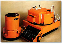
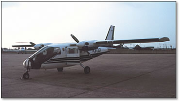
The LMK 2000’s gyro-mount and forward motion compensation capability ensured sharp, perfectly vertical imagery at slow shutter speeds. It was USGS-certified and underwent annual maintenance. It was mounted in a Partenavia P-68 Observer 2, a fixed-wing, twin-engine aircraft manufactured in Italy and designed for observation. It is a very distinctive plane, due to its Plexiglas nose. The LMK 2000 has two film magazines that will handle 200-foot rolls of 9”X9” film each, and is capable of collecting approximately 225 images per roll before needing to land for magazine reloading. More information on this plane is available here.
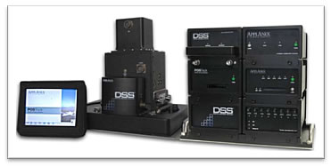
As the LMK 2000 camera and gyro-mount continued to age and required more frequent repairs, a conversion to a digital camera was considered. Digital aerial cameras began appearing in the early 2000s and quickly established themselves as viable alternatives to traditional analog cameras. There were many advantages to moving to a digital camera, including virtually unlimited film payload, immediate image quality feedback, extensive image metadata, a lightweight, small footprint system, and rapid image processing and orthorectification (which is the process of referencing aerial photos to the earth). In the spring of 2009, after an open Request For Proposal and exhaustive selection process, the USGS-certified Applanix DSS 439 digital aerial camera was selected to replace the LMK 2000. More information on this camera is available here. In October 2009, Kodak announced that due to decreasing demand, they would cease production of color infrared aerial film, confirming the decision to move to digital collection.
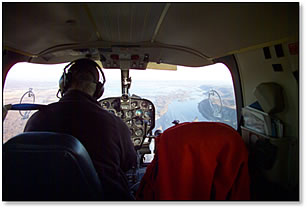
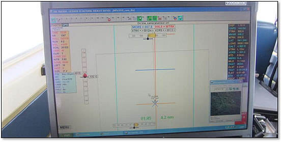
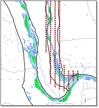
The process of developing a flight plan for a given project has changed little over the years but the tools used have changed considerably. Once a study area has been identified, a suitable photo scale or resolution is selected and flight lines are established, typically at 60% overlap to allow for stereo viewing, and 30% sidelap to ensure there are no gaps in photo coverage when more than one flight line is needed. Flight planning software automatically generates flight lines and photo centers once these values are entered and the study area is imported. The flight plan is then exported for use in the plane’s navigation laptop, as shown below.
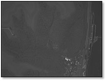
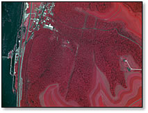
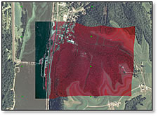
While analog 9X9 imagery requires handling in complete darkness and, once exposed, is shipped to specialized photo labs for processing and printing, images collected with a digital aerial camera are saved to a pressurized hard drive and processed later on a laptop in the hotel room or on a workstation in the office depending on how quickly the images are needed. DSS 439 images are collected with a 40 mm lens using either a CIR or TC filter and then processed to the appropriate format by calculating a ‘white balance’ from a neutral gray surface such as a parking lot or roof top. Once, photo-corrected TIFFs are generated, they are ready to be referenced to the earth. That process is illustrated below, from the unrotated raw image to the final orthorectified aerial overlaying a National Agricultural Imagery Program digital ortho mosaic.
![]()
![]()
To facilitate this process, most digital aerial cameras employ both a Global Positioning System (GPS) to track the plane’s location on the earth and an inertial measurement unit (IMU) to track the camera sensor’s precise position in terms of roll, pitch and yaw at the time of exposure. This information is output as a comma-delimited text file and can be used by geographic information system (GIS) software to perform extremely accurate georeferencing of aerial imagery. It is also used to generate stereo models which are then used for viewing and interpreting aerial photos on-screen with 3d stereo monitors (more info on this process is available on the “New Technologies” page). Digital elevation models (DEM) can be used to further refine the image’s placement on the earth by ‘draping’ or warping the image to the landscape so that it is no longer perfectly rectangular but it is much more accurate.
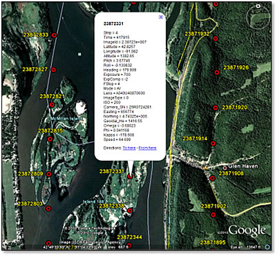
An example of the information collected at exposure is shown below for a single image. Values with an * are formula-based values calculated separately.
|
This GPS/IMU-generated information can be used to create a data layer showing each exposure’s details and location on the earth using GIS software such ArcMap or Google Earth.
|
Impact of UMESC Science
Aerial photography is one of the best methods for tracking long-term changes of dynamic river systems. UMESC's aerial photo inventory, with assistance from other federal and state agencies, extends back to the 1920s prior to the construction of locks and dams in the 1930s and 40s. This imagery, combined with systemic collections in 1989, 2000, and 2010/11, offers a photographic record of change extending back almost a century and gives insight into how conditions might continue to change into the future.
Component specialist: Larry Robinson
Brand name disclaimer: Mention of trade names or commercial products does not constitute endorsement or recommendation for use by the U.S. Department of Interior, U.S. Geological Survey.

Page Last Modified: April 2, 2018