
 |
Upper Mississippi River Restoration ProgramLong Term Resource Monitoring |
|
| |
||
Macroinvertebrates
|
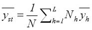
MethodsMacroinvertebrate sampling procedures are described in detail in the LTRMP Procedures Manual (Thiel and Sauer 1999). The sampling of mayflies (Ephemeridae), fingernail clams (Sphaeriidae), and Asiatic clams (Corbicula sp.) began in 1992 in Pools 4, 8, 13, and 26, the Open River Reach of the Mississippi River, and La Grange Pool of the Illinois River (Figure 1). Midges (Chironomidae) were added to the sampling design in 1993 and the exotic zebra mussel (Dreissena polymorpha) in 1995. The presence or absence of Odonata, Plecoptera, Trichoptera, Diptera, Bivalvia, Oligochaeta, Decapoda, Amphipoda, and Gastropoda was also reported. Sites included randomly selected locations distributed among key aquatic strata—based on enduring geomorphic features (Wilcox 1993). Aquatic strata sampled included contiguous backwaters, which have apparent surface water connection with the rest of the river; main channel borders, the area between the navigational buoys and the riverbank—not including revetments and channel-training structures; impounded areas, large, mostly open-water areas located in the downstream portion of the navigation pools; and side channels, channels that carry less flow than the navigation channel. For Pool 4, the impounded area is in the form of Lake Pepin, a tributary delta lake formed by the Chippewa River delta. In this report, only data from the randomly selected sites are discussed. The LTRMP staff developed a spatial database of aquatic areas (Owens and Ruhser 1996) on the basis of aerial photography produced in 1989. This database was used for randomized selection of sampling sites and the quantification of sampling strata. Annual sampling was conducted at about 120 sites per study area (Table 1). Sample allocation was based on several criteria, including surface area of the aquatic area in each study reach, ability to sample within a specific strata, and the productivity of the taxa in each aquatic area. All sites were sampled in early spring, before emergence of mayflies and vegetation growth. Benthic samples were collected with a winch-mounted 23- × 23-cm (0.052-m2) standard Ponar grab sampler (Ponar Grab Dredge, Wildlife Supply Company, Saginaw, Michigan). The wash frame sieve size was changed from a U.S. Standard Sieve no. 30 (0.595 µm), used in 1992, to a U.S. Standard Sieve no. 16 (1.18 mm) in 1993. Samples washed through the 1.18-mm mesh retain only the larger taxa and life stages of the invertebrate community (Dukerschein et al. 1996). Mayflies, fingernail clams, midges (>1 cm), Asiatic clams, and zebra mussels were removed from each sample and counted. Site Information Field crews qualitatively categorized the substrate and vegetation at each sampling site. They classified substrate composition in the Ponar samples into one of six categories: hard clay, silt clay, silt clay with sand, sand with silt clay, sand, and gravel rock. They recorded the percentage of submersed and floating-leaved aquatic vegetation in the column of water through which the Ponar dredge fell. Also, the crews recorded the type and percent cover of vegetation and open water within a 15-m radius from the boat. Water depth was also measured at each site. Statistical Analyses Total catch was recorded for each target taxa from individual Ponar samples. The reachwide estimated mean densities of taxa was based on by pooling data over all strata selected for macroinvertebrate sampling (Sauer 1998). These estimates track relative densities at the broadest possible spatial scale and can be used to evaluate areawide trends in abundance. If the quantity of preferred habitats declines through time while densities in those preferred habitats remains constant, these pooled mean density statistics should reflect that decline. The estimates of pooled reachwide mean densities were obtained
from the conventional design-based estimator for stratified random
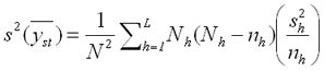
samples (Cochran 1977). The estimated reachwide mean, denoted
where Nh is the number of sampling units within
stratum h, L is the total number of strata,
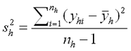
is the estimator of the variance of yh and nh is the number of samples taken in stratum h (Cochran 1977).
The standard error of Equation (2) is used to obtain estimates of overall mean densities for stratified random sampling. In random samples, equation (2) yields unbiased estimates of the reachwide means regardless of the probability distribution of y (Cochran 1977). For LTRMP macroinvertebrate monitoring, the sampling units are the 50-m2 sampling grids. Annual Changes in Methods
|
|||||||||||||||||||||||||||||||||||||||||||
 (1)
(1) (2)
(2)

Page Last Modified: November 23, 2020