
 |
Upper Mississippi River Restoration ProgramLong Term Resource Monitoring |
|
| |
||
Fisheries |
||
Management-relevant presumptive fish habitat models in a large river system
Brian S. Ickes
U.S. Geological Survey
Upper Midwest Environmental Sciences Center
2630 Fanta Reed Road
La Crosse, WI 54603
Guidance for Crediting UMRR and its Long Term Resource Monitoring element
Introduction
Habitat rehabilitation efforts on the Upper Mississippi River System (UMRS) are designed and planned in partnership ventures between Federal and State science and management agencies under the auspices of a Congressionally defined program known as the Upper Mississippi River Restoration Program (UMRR). Since 1989, more than 41,000 ha of habitat have been rehabilitated in the UMRS valley by the UMRR, representing ~ 4% of total rehabilitation potential.
As rehabilitation practices have evolved, increasingly cost-benefit analysis and pre and post project assessments have become a major part of rehabilitation efforts, both to ensure cost-benefit efficacy and to adaptively learn best practices that can be carried forward into future habitat rehabilitation efforts. Data driven and science informed approaches to habitat rehabilitation are now the norm in habitat rehabilitation planning and design efforts on the UMRS. Correspondingly, new technical methods increasingly support habitat rehabilitation efforts in the UMRS basin, and this is an active area of work by technical and scientific assets in the UMRS basin. Examples include Status and Trends assessments of natural resources within the UMRS basin (USGS 1999; Johnson and Hagerty, eds. 2008), Decision Support Systems that help managers bring volumes of data and maps into the project planning forums, and spatially-explicit models that seek to define and predict important ecological responses so that managers can forecast prospective project benefits (Ickes et al. 2014a).
This project page describes and provides access to resources resulting from recent efforts to generate spatially-explicit habitat models for 28 fish species (Ickes et al. 2014a) over 1900 km of river, using unprecedented data assets available through the UMRR’s Long Term Resource Monitoring (LTRM) element. Included are links to the data used to create the habitat models, descriptions of the methods used, publications generated by these efforts, and spatially-explicit presumptive fish habitat maps for many species. These resources stand in support of habitat planning and design efforts across the UMRS.
Data
The data derived from the UMRR LTRM and were gained through public portals to the raw data. Data represented all sample site scale day electrofishing observations 1993-2014, from each of the six study reaches monitored by the LTRM (Figure 1). From these data, 28 fish species representing lentic, lotic, and generalist habitat guilds (O’Hara et al. 2007) were selected for modeling. All catch data were transformed from abundance (continuous) data to presence/absence (binary) data. In addition, 17 sample site-specific environmental variables observed synoptically with the catch data were retained for modeling as predictors of species occurrence at each sampling site. All LTRM data are collected using highly standardized sampling methods and using a randomized statistical design (Ratcliff et al. 2014; Ickes et al. 2014b). The data represent a 22 year random sample of each of the six study reaches. This randomization in sample design assures unbiased (representative) observations of both fish observations and environmental attributes associated with each fish observation. The 28 species that were modeled, including their habitat guild designations, are presented in Table 1. The environmental variables and their data attributes are presented in Table 2.
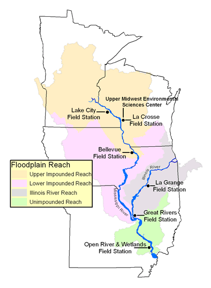
Figure 1. Locations of the six UMRR LTRM study reaches. The six reaches average 50 km in length and 2.5 km in width.
Table 1. Fish species selected for modeling.
| Species | Scientific name | Guild |
| Black crappie | Pomoxis nigromaculatus | Lentic |
| White crappie | Pomoxis annularis | Lentic |
| Bluegill | Lepomis macrochirus | Lentic |
| Largemouth bass | Micropterus salmoides | Lentic |
| Warmouth | Lepomis gulosus | Lentic |
| Northern pike | Esox lucius | Lentic |
| Yellow perch | Perca flavescens | Lentic |
| Blue catfish | Ictalurus furcatus | Lotic |
| Flathead catfish | Pylodictis olivaris | Lotic |
| Rock bass | Ambloplites rupestris | Lotic |
| Skipjack herring | Alosa chrysochloris | Lotic |
| Blue sucker | Cycleptus elongates | Lotic |
| Shovelnose sturgeon | Scaphirhynchus platorynchus | Lotic |
| Sauger | Sander canadense | Lotic |
| Golden redhorse | Moxostoma erythrurum | Lotic |
| Shorthead redhorse | Moxostoma macrolepidotum | Lotic |
| Channel catfish | Ictalurus punctatus | Generalist |
| Red shiner | Cyprinella lutrensis | Generalist |
| Logperch | Percina caprodes | Generalist |
| Brook silverside | Labidesthes sicculus | Generalist |
| Freshwater drum | Aplodinotus grunniens | Generalist |
| Emerald shiner | Notropis atherinoides | Generalist |
| Blackstripe topminnow | Fundulus notatus | Generalist |
| Smallmouth bass | Micropterus dolomieu | Generalist |
| Longnose gar | Lepisosteus osseus | Generalist |
| White bass | Morone chrysops | Generalist |
| Smallmouth buffalo | Ictiobus bubalus | Generalist |
| Walleye | Sander vitreum | Generalist |
Table 2. Environmental variables observed synoptically with Upper Mississippi River Restoration Program Long Term Resource Monitoring element’s fish component sampling in the Upper Mississippi River System. Methods associated with recording environmental observations, in highly standardized ways, are detailed in Gutreuter et al. (1995) and Ratcliff et al. (2014).
| Variable name | Abbreviation | Variable type | Unit(s) |
| Environmental variables | |||
| Secchi | Secchi | Continuous | cm (nearest 1) |
| Conductivity | SpecCond | Continuous | µS/cm (nearest 1) |
| Water velocity | Watervel | Continuous | m/s (nearest 0.1) |
| Water temperature | Temp | Continuous | °C (nearest 0.1) |
| Water depth | Depth | Continuous | m (nearest 0.1) |
| Dissolved Oxygen | DO | Continuous | mg/L (nearest 0.1) |
| % emergent submersed vegetation | AqVeg | Categorical (4 categories) | % |
| Vegetation Density | VegDens | Categorical (2 categories) | scaleless |
| Predominant substrate | Substrate | Categorical (4 categories) | descriptive |
| Other structures | |||
| Woody debris | Woody | Binary | Presence absence |
| Tributary mouth | Trib | Binary | Presence absence |
| Inlet/outlet channel | InOut | Binary | Presence absence |
| Flooded terrestrial | FloodTer | Binary | Presence absence |
| Wing dam/dyke | WingDam | Binary | Presence absence |
| Revetment | Revetment | Binary | Presence absence |
| Low-head dam, closing dam, weir | LowHead | Binary | Presence absence |
| Diagnostic variables |
|||
| Field station | Fstation | Diagnostic | Numeric ordinal label |
| Period | Period | Diagnostic | Numeric ordinal label |
Methods
Given intentions to model the probability of occurrence for 28 fish species within each of the six LTRM study reaches (Figure 1), we chose Multiple Logistic Regression (MLR) with binary responses (SAS version 9.3; Proc Logistic) as our modeling framework. For each species, the probability of occurrence is modeled as a function of 17 environmental variables measured synoptically with fish observations (Table 2).
Initially, we intended to use data from all six LTRMP stations and develop “systemic models” for each species, resulting in 28 species-specific models. However, it proved largely impossible to get good fits for the systemic models. Thus, we divided the UMRS into regions, and developed an “Upper UMRS” regional model for each species using LTRM study reaches Pools 4, 8, and 13, and a “Lower UMRS” model for each species using LTRM study reaches Pool 26, Open River, and La Grange. This resulted in 56 attempted models. To fit this many models, and gain predictions, we had to simplify the approach and apply it uniformly across all intended models, given constrained resources.
Although we used species presence/absence data, we modeled only presences, or positive observations, and not absences, which may derive from a species either actually being absent, or simply not detected. The LTRM fish component does not collect information to adjust for non-detects in the determination of absences, and other available methods for dealing with this issue required adopting additional assumptions we could not test. Importantly, the goal here is to develop models to predict relative differences in habitat suitability based upon observed presences and their association with observed synoptic environmental data sources, not necessarily an adjusted and more accurate estimate of site occupancy. As such, estimates and predictions arising from these models should be viewed as conservative under-estimates because occurrence probabilities would resolve higher if we could adjust for non-detection. The important results are the relative comparisons and differences among model predictions in space, useful for identifying suitable or unsuitable conditions and considering habitat rehabilitation project siting.
Habitat Maps
Spatially-explicit predictions of the probability of occurrence for each fish species and modeling region were provided by the models reported in Ickes et al. (2014a). These predictions are georeferenced, and are therefore able to be mapped. Work in 2015 used the predictions of Ickes et al. (2014a) to generate maps of the probability of occurrence for each modeled fish species within each of the six LTRM study reaches. Predictions are mapped and provided as (1) point estimates; and (2) interpolated prediction surfaces. The interpolated prediction surfaces were generated using spatial interpolation methods, specifically, the splines with barriers method. This method constrains interpolations from crossing land/water boundaries and was the most conservative method available, as well as the method that introduced the fewest additional assumptions into the predicted mapped surfaces. Maps can be gained for any well-fit model, species, and LTRM study reach using the tables below.
| Viewable PDF versions of habitat maps | |||||||
| Upper Reach Models | Lower Reach Models | ||||||
| Species | Scientific name | Pool 4 | Pool 8 | Pool 13 | Pool 26 | Open River | La Grange |
| Black crappie | Pomoxis nigromaculatus | p04_bkcp.pdf | p08_bkcp.pdf | p13_bkcp.pdf | |||
| White crappie | Pomoxis annularis | ||||||
| Bluegill | Lepomis macrochirus | p04_blgl.pdf | p08_blgl.pdf | p13_blgl.pdf | |||
| Largemouth bass | Micropterus salmoides | p04_lmbs.pdf | p08_lmbs.pdf | p13_lmbs.pdf | |||
| Warmouth | Lepomis gulosus | p04_wrmh.pdf | p08_wrmh.pdf | p13_wrmh.pdf | |||
| Northern pike | Esox lucius | p04_ntpk.pdf | p08_ntpk.pdf | p13_ntpk.pdf | |||
| Yellow perch | Perca flavescens | p04_ywph.pdf | p08_ywph.pdf | p13_ywph.pdf | |||
| Blue catfish | Ictalurus furcatus | p26_blcf.pdf | or_blcf.pdf | lg_blcf.pdf | |||
| Flathead catfish | Pylodictis olivaris | p04_fhcf.pdf | p08_fhcf.pdf | p13_fhcf.pdf | p26_fhcf.pdf | or_fhcf.pdf | lg_fhcf.pdf |
| Rock bass | Ambloplites rupestris | p04_rkbs.pdf | p08_rkbs.pdf | p13_rkbs.pdf | |||
| Skipjack herring | Alosa chrysochloris | ||||||
| Blue sucker | Cycleptus elongates | p04_busk.pdf | p08_busk.pdf | p13_busk.pdf | p26_busk.pdf | or_busk.pdf | lg_busk.pdf |
| Shovelnose sturgeon | Scaphirhynchus platorynchus | ||||||
| Sauger | Sander canadense | p04_sger.pdf | p08_sger.pdf | p13_sger.pdf | p26_sger.pdf | or_sger.pdf | lg_sger.pdf |
| Golden redhorse | Moxostoma erythrurum | p26_gdrh.pdf | or_gdrh.pdf | lg_gdrh.pdf | |||
| Shorthead redhorse | Moxostoma macrolepidotum | p04_shrh.pdf | p08_shrh.pdf | p13_shrh.pdf | p26_shrh.pdf | or_shrh.pdf | lg_shrh.pdf |
| Channel catfish |
Ictalurus punctatus |
||||||
| Red shiner | Cyprinella lutrensis | ||||||
| Logperch | Percina caprodes | p04_lgph.pdf | p08_lgph.pdf | p13_lgph.pdf | p26_lgph.pdf | or_lgph.pdf | lg_lgph.pdf |
| Brook silverside | Labidesthes sicculus | p04_bkss.pdf | p08_bkss.pdf | p13_bkss.pdf | p26_bkss.pdf | or_bkss.pdf | lg_bkss.pdf |
| Freshwater drum | Aplodinotus grunniens | p04_fwdm.pdf | p08_fwdm.pdf | p13_fwdm.pdf | p26_fwdm.pdf | or_fwdm.pdf | lg_fwdm.pdf |
| Emerald shiner | Notropis atherinoides | p04_ersn.pdf | p08_ersn.pdf | p13_ersn.pdf | p26_ersn.pdf | or_ersn.pdf | lg_ersn.pdf |
| Blackstripe topminnow | Fundulus notatus | p26_bttm.pdf | or_bttm.pdf | lg_bttm.pdf | |||
| Smallmouth bass | Micropterus dolomieu | ||||||
| Longnose gar | Lepisosteus osseus | p04_lngr.pdf | p08_lngr.pdf | p13_lngr.pdf | p26_lngr.pdf | or_lngr.pdf | lg_lngr.pdf |
| White bass | Morone chrysops | p04_wtbs.pdf | p08_wtbs.pdf | p13_wtbs.pdf | p26_wtbs.pdf | or_wtbs.pdf | lg_wtbs.pdf |
| Smallmouth buffalo | Ictiobus bubalus | p04_smbf.pdf | p08_smbf.pdf | p13_smbf.pdf | |||
| Walleye | Sander vitreum | p26_wlye.pdf | or_wlye.pdf | lg_wlye.pdf | |||
| GIS IMG files and XML Metadata | |||||||
| Upper Reach Models | Lower Reach Models | ||||||
| Species | Scientific name | Pool 4 | Pool 8 | Pool 13 | Pool 26 | Open River | La Grange |
| Black crappie | Pomoxis nigromaculatus | p04_bkcp.exe | p08_bkcp.exe | p13_bkcp.exe | |||
| White crappie | Pomoxis annularis | ||||||
| Bluegill | Lepomis macrochirus | p04_blgl.exe | p08_blgl.exe | p13_blgl.exe | |||
| Largemouth bass | Micropterus salmoides | p04_lmbs.exe | p08_lmbs.exe | p13_lmbs.exe | |||
| Warmouth | Lepomis gulosus | p04_wrmh.exe | p08_wrmh.exe | p13_wrmh.exe | |||
| Northern pike | Esox lucius | p04_ntpk.exe | p08_ntpk.exe | p13_ntpk.exe | |||
| Yellow perch | Perca flavescens | p04_ywph.exe | p08_ywph.exe | p13_ywph.exe | |||
| Blue catfish | Ictalurus furcatus | p26_blcf.exe | or_blcf.exe | lg_blcf.exe | |||
| Flathead catfish | Pylodictis olivaris | p04_fhcf.exe | p08_fhcf.exe | p13_fhcf.exe | p26_fhcf.exe | or_fhcf.exe | lg_fhcf.exe |
| Rock bass | Ambloplites rupestris | p04_rkbs.exe | p08_rkbs.exe | p13_rkbs.exe | |||
| Skipjack herring | Alosa chrysochloris | ||||||
| Blue sucker | Cycleptus elongates | p04_busk.exe | p08_busk.exe | p13_busk.exe | p26_busk.exe | or_busk.exe | lg_busk.exe |
| Shovelnose sturgeon | Scaphirhynchus platorynchus | ||||||
| Sauger | Sander canadense | p04_sger.exe | p08_sger.exe | p13_sger.exe | p26_sger.exe | or_sger.exe | lg_sger.exe |
| Golden redhorse | Moxostoma erythrurum | p26_gdrh.exe | or_grdh.exe | lg_grdh.exe | |||
| Shorthead redhorse | Moxostoma macrolepidotum | p04_shrh.exe | p08_shrh.exe | p13_shrh.exe | p26_shrh.exe | or_shrh.exe | lg_shrh.exe |
| Channel catfish |
Ictalurus punctatus |
||||||
| Red shiner | Cyprinella lutrensis | ||||||
| Logperch | Percina caprodes | p04_lgph.exe | p08_lgph.exe | p13_lgph.exe | p26_lgph.exe | or_lgph.exe | lg_lgph.exe |
| Brook silverside | Labidesthes sicculus | p04_bkss.exe | p08_bkss.exe | p13_bkss.exe | p26_bkss.exe | or_bkss.exe | lg_bkss.exe |
| Freshwater drum | Aplodinotus grunniens | p04_fwdm.exe | p08_fwdm.exe | p13_fwdm.exe | p26_fwdm.exe | or_fwdm.exe | lg_fwdm.exe |
| Emerald shiner | Notropis atherinoides | p04_ersn.exe | p08_ersn.exe | p13_ersn.exe | p26_ersn.exe | or_ersn.exe | lg_ersn.exe |
| Blackstripe topminnow | Fundulus notatus | p26_bttm.exe | or_bttm.exe | lg_bttm.exe | |||
| Smallmouth bass | Micropterus dolomieu | ||||||
| Longnose gar | Lepisosteus osseus | p04_lngr.exe | p08_lngr.exe | p13_lngr.exe | p26_lngr.exe | or_lngr.exe | lg_lngr.exe |
| White bass | Morone chrysops | p04_wtbs.exe | p08_wtbs.exe | p13_wtbs.exe | p26_wtbs.exe | or_wtbs.exe | lg_wtbs.exe |
| Smallmouth buffalo | Ictiobus bubalus | p04_smbf.exe | p08_smbf.exe | p13_smbf.exe | |||
| Walleye | Sander vitreum | p26_wlye.exe | or_wlye.exe | lg_wlye.exe | |||
This study was conducted by the U.S. Army Corps of Engineers’ Upper Mississippi River Restoration Program Long Term Resource Monitoring (LTRM) element. The LTRM is a cooperative effort between the U.S. Army Corps of Engineers, U.S. Geological Survey, U.S. Fish and Wildlife Service, and the states of Illinois, Iowa, Minnesota, Missouri, and Wisconsin. Any use of trade, firm, or product names is for descriptive purposes only and does not imply endorsement by the U.S. Government.
Literature cited
Gutreuter, S., R. Burkhardt, and K. Lubinski. 1995. Long Term Resource Monitoring Program procedures: Fish monitoring. National Biological Service, Environmental Management Technical Center, Onalaska, Wisconsin, July 1995. LTRMP 95-P002-1. 42 pp. + Appendixes A–J.
Ickes, B. S., J. S. Sauer, N. Richards, M. Bowler, and B. Schlifer. 2014a. Spatially-explicit habitat models for 28 fishes from the Upper Mississippi River System (AHAG 2.0). A Program Report submitted to the U.S. Army Corps of Engineers’ Upper Mississippi River Restoration-Environmental Management Program from the U.S. Geological Survey, Upper Midwest Environmental Sciences Center, La Crosse, Wisconsin. January 2014. LTRMP Program Report 2014-P001. 26 pp. + Appendixes A–B.
Ickes, B.S., Sauer, J.S., and Rogala, J.T., 2014b, Monitoring rationale, strategy, issues, and methods: UMRR-EMP LTRMP Fish Component. A program report submitted to the U.S. Army Corps of Engineers’ Upper Mississippi River Restoration-Environmental Management Program, Program Report LTRMP 2014–P001a, 29 p., http://pubs.usgs.gov/mis/ltrmp2014-p001a/
Johnson, B. L., and K. H. Hagerty, editors. 2008. Status and trends of selected resources of the Upper Mississippi River System. U.S. Geological Survey, Upper Midwest Environmental Sciences Center, La Crosse, Wisconsin, December 2008. LTRMP Technical Report 2008-T002. 102 pp. + Appendixes A–B. Report available online at http://pubs.usgs.gov/mis/LTRMP2008-T002/
O’Hara, M., B. S. Ickes, E. Gittinger, S. DeLain, T. Dukerschein, M. Pegg, and J. Kalas 2007. Development of a life history database for Upper Mississippi River fishes. U.S. Geological Survey, Upper Midwest Environmental Sciences Center, La Crosse, Wisconsin. LTRMP 2007-T001. 10 pp. + Appendixes A–B. (NTIS ADA470170)
Ratcliff, E. N., E. J. Gittinger, T. M. O’Hara, and B. S. Ickes. 2014. Long Term Resource Monitoring Program procedures: Fish monitoring, 2nd edition. A Program Report submitted to the U.S. Army Corps of Engineers’ Upper Mississippi River Restoration-Environmental Management Program from the U.S. Geological Survey, Upper Midwest Environmental Sciences Center, La Crosse, Wisconsin. February 2014. LTRMP Program Report 2013-P001 91 pp. including Appendixes A–G.
U.S. Geological Survey (USGS). 1999. Ecological status and trends of the Upper Mississippi River system 1998. A report of the Long Term Resource Monitoring Program. U.S. Geological Survey, Upper Midwest Environmental Sciences Center, La Crosse, Wisconsin. LTRMP 99-T001. 236 pp.

Page Last Modified: November 17, 2020