
 |
Upper Mississippi River Restoration ProgramLong Term Resource Monitoring |
|
| |
||
Light Detection And Ranging (Lidar) Elevation Data |
||
|
Light Detection And Ranging (Lidar) generates extremely accurate (vertical and horizontal) location information and has long been a desired product for the Upper Mississippi River System (UMRS). Previously, the best publicly available elevation data for the entire UMRS was at a resolution of 30 meters/cell, though 10 meter/cell data have been available for many areas. Now, Lidar-derived elevation data are available for much of the UMRS at 1 meter/cell resolution, with additional navigation pools being added regularly as those data are processed. In 2007, the U.S Army Corps of Engineers’ Upper Mississippi River Restoration (UMRR) Program Long Term Resource Monitoring (LTRM) element partnered with the Iowa Department of Natural Resources (IDNR) to collect high-quality, bluff-to-bluff Lidar for Navigation Pools 8-24 of the UMRS. The IDNR also provided preliminary processing of the raw data as part of the partnership agreement. The Upper Midwest Environmental Sciences Center (UMESC), in partnership with the UMRR Program, is the lead agency in the final processing of the Lidar data which includes additional quality control, and serving the Lidar products on the UMESC’s website for the UMRR Program Long Term Resource Monitoring (LTRM) element. |
In 2009, with American Recovery and Reinvestment (ARRA) funds awarded to the UMRR Program, Lidar was collected for the Upper Mississippi River from Pool 25 to the confluence with the Ohio River, and for the Illinois River was contracted. Data acquisition for this area was completed in 2011 and processing of these data remains in progress. Other agencies, such as the State of Minnesota, State of Illinois, State of Missouri, the U.S. Geological Survey, and the Corps, provided recent Lidar data for other areas within the UMRS, reducing the UMRR Program’s collection effort.
Lidar is acquired using laser and light sensors mounted in aircraft. The units perform vertical sweeps of the ground below, painting the surface with thousands of laser pulses per second. The pulse’s reflection is calculated by time sent/received and by return intensity. Lidar can accurately generate cells of a meter or less and support creation of two-foot contours. Horizontal accuracy of spot elevations are less than one meter and vertical accuracy is typically six-inches or better.
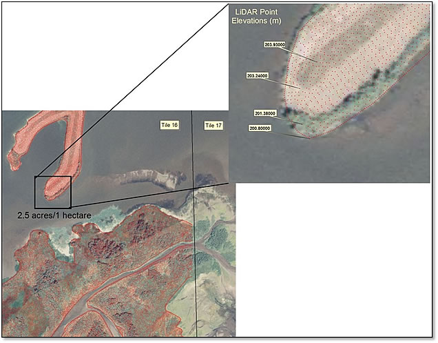
Lidar postings showing bare earth heights.
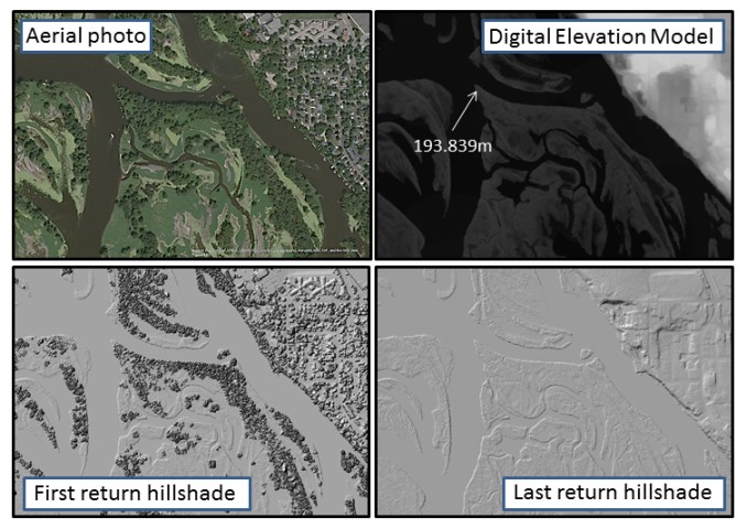
UMESC has been working with Lidar data for nearly a decade and has established itself as a leader in Lidar processing. Among the products derived from Lidar, detailed, bare-earth digital elevation models (DEMs) of the floodplain are expected to be most useful. DEMs are constructed from XY (horizontal) and Z (vertical) Lidar returns. From these values, contours and triangular irregular networks (TINs) can be generated for use in models and habitat analyses. Lidar products UMESC plans to serve for the UMRR Program LTRM element spatial data include DEMs, contours, and hillshades. Examples of each are shown below.
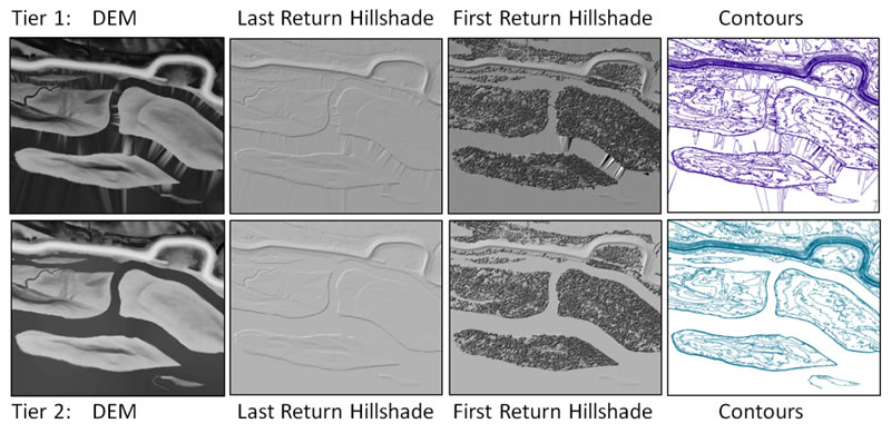
Lidar products were developed with two levels of processing, known as “Tier 1” and “Tier 2”. Tier 1 products are derived directly from vendor-provided LAS-format (LASer) files that have not been cleaned or edited in order to serve the data as quickly as possible. Tier 1 data have been quality checked by the vendor and obvious errors removed, but some isolated errors often remain. Tier 2 data are derived from Tier 1 by performing water-masking, contour-smoothing, and point-reclassification where necessary, and conducting an additional quality control phase, as defined below. Once Lidar products have undergone Tier 2 processing, the associated Tier 1 products are removed from the web site.
Tier 2 processing includes:
- flattening of water – which was done using two methods. The first was masking of water, which was implemented on the offshore aquatic areas, and the second was hydro-enforcement, which was implemented on streams and rivers.
- Masking of water – assigns a single elevation value to a body (or section) of water to produce a more aesthetically pleasing DEM. Because water absorbs most of the lidar signal, there are few elevation points on water surfaces. Un-flattened aquatic areas generate large, flat triangles as isolated surface because shoreline points are tied together. Small errors or random variation due to signal absorption can result in slight differences in elevation of these triangles. Masking eliminates these small differences and creates a completely flat water surface.
- Hydro-enforcement of streams and rivers – this provides decreasing elevation values on the streams and rivers as they flow downstream. Since the main channel can be very variable, assigning a single elevation for the entire stretch of the river would have been inconsistent and could produce inaccurate results. Hydro-enforcement also enables hydrologic and hydraulic models to represent water flow under structures, such as bridges.
- smoothing of contours - this step improves the visual appearance of elevation contours. Because contour lines are initially generated as straight lines interpolated from, in our case, 1-m DEM horizontal cells at a 0.5m vertical increment, they can appear very angular. Smoothing sacrifices a small amount of precision to improve the visual quality of the contour lines. This also reduces the number of data points, making the data easier to display and analyze on a computer.
- reclassifying of data errors - Misclassification errors show up primarily along edges and in relatively small landscape features, such as small islands. Occasionally data in transition zones may be classified as vegetation or land on one tile and as water on the adjacent tile so that there appears to be an unnatural straight line between tiles when displaying these data by class. Also, small islands maybe lost when areas are broadly classified as water. Using background imagery to reclassify these errors improves the accuracy of the final product.
- additional quality assurance/quality control assessment - the best way to catch classification errors is by a focused review at the tile level using both hillshades and the highest resolution background imagery available. Anomalies can be either noted and repaired in the reclassification process or, if systemic, brought to the attention of the vendor.
Many information needs can be met using individual Lidar products, but integrated elevation data, combining Lidar and bathymetry data, are required in some cases. For example, where bathymetry data are available, hydrodynamic models used to predict flow and inundation have been limited to predictions in low water conditions. Other examples are information on near-shore habitat use by water birds, fish spawning and marshland vegetation. Using specialized Geographical Information System (GIS)-software and high-speed computer processors, we are in the process of merging Lidar and bathymetric data into a seamless GIS layer of land elevation. These seamless elevation layers, determined by pools where Lidar and bathymetry are complete, will be available for Pools 4-5, 7-10, 13, and 21, and classified as Tier 3 products.
All Lidar products generated for UMRR Program LTRM element by UMESC are available for download on the data download pages.
Examples of Lidar products are shown below.
![]() Lidar data are remotely sensed, high-resolution elevation data collected by airplane. The UMESC processed these data to create Digital Elevation Models (DEMs), 0.5 meter contour lines, and pool-wide hillshade images. Tier 2 processing has been completed for all pools and those products are available on the data download pages. This process includes water-masking, contour-smoothing, point reclassification, where needed, and additional quality control steps. The collection and processing of these data were funded by the U.S. Army Corps of Engineers’ UMRR Program, LTRM element.
Lidar data are remotely sensed, high-resolution elevation data collected by airplane. The UMESC processed these data to create Digital Elevation Models (DEMs), 0.5 meter contour lines, and pool-wide hillshade images. Tier 2 processing has been completed for all pools and those products are available on the data download pages. This process includes water-masking, contour-smoothing, point reclassification, where needed, and additional quality control steps. The collection and processing of these data were funded by the U.S. Army Corps of Engineers’ UMRR Program, LTRM element.
Impact of UMESC Science
High-resolution elevation derivatives, such as those generated from Lidar data, are useful for many reasons – flow, inundation, and run-off model building, habitat project design and evaluations, floodplain forest height and density information, connectivity analyses, and seamless 3-D model generations by pool or reach to name a few. Lidar data will also assist in the development of LCU products by informing botanists and GIS specialists about floodplain vegetation's slope, aspect, and elevation above the water table. Many Lidar sensors can receive multi-returns, which can be processed to describe heights of overstory and understory vegetation and the relative density of the forest canopy.
Point of Contact: Jennifer Dieck
Disclaimer: Tier 2 Lidar data have gone through quality assurance testing and have been approved for release by the USGS. Although Tier 2 data have been subjected to rigorous review and are substantially complete, the USGS reserves the right to revise these data pursuant to further analysis and review. Furthermore, Tier 2 data are released on condition that neither the USGS nor the United States Government may be held liable for any damages resulting from their authorized or unauthorized use.

Page Last Modified: April 2, 2018