|
Prior to widespread European settlement of the region, the Upper Mississippi
River Basin was a diverse landscape of tallgrass prairie, wetlands, savannas,
and forests. Logging, agriculture, and urban development over the past
150 years 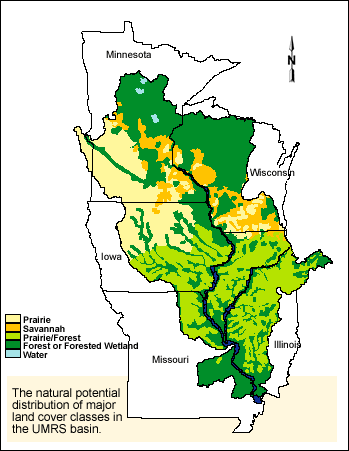 has
resulted in the present landscape that is more than 80 percent developed.
Millions of acres of wetland drainage, thousands of miles of field tiles,
road ditches, channelized streams, and urban stormwater sewers accelerate
runoff to the mainstem rivers. The modern hydrologic regime is highly
modified, with increased frequency and amplitude of changes in river discharge.
Dams and river regulation throughout the basin also modify river flows.
The modern basin landscape delivers large amounts of sediment, nutrients,
and contaminants to the river. has
resulted in the present landscape that is more than 80 percent developed.
Millions of acres of wetland drainage, thousands of miles of field tiles,
road ditches, channelized streams, and urban stormwater sewers accelerate
runoff to the mainstem rivers. The modern hydrologic regime is highly
modified, with increased frequency and amplitude of changes in river discharge.
Dams and river regulation throughout the basin also modify river flows.
The modern basin landscape delivers large amounts of sediment, nutrients,
and contaminants to the river.
At the system-wide scale there were natural gradients in habitat among
river reaches. Northern river reaches were more forested and were composed
of mixed silver maple forests, river channels, seasonally flooded backwaters,
floodplain lakes, marsh, and prairie. Beginning around the northern Iowa
border and along the lower Illinois River, grasslands and oak savanna
dominated floodplain plant communities. Historic surveys reveal a higher
proportion of oaks and other mast trees in the forest community than at
present. Below the Kaskaskia River, the floodplain was heavily forested
with species characteristic of southern bottomland hardwood communities.
Impacts of river floodplain development include forest loss and water
gain in northern reaches, and grassland and forest losses in the rest
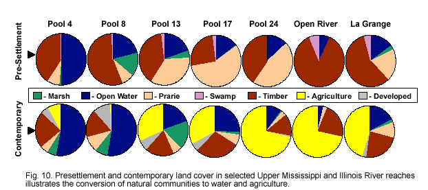
of the UMRS. (see Table 4, Fig. 10 below).
At the pool scale since impoundment, sediment accumulation and littoral
(i.e., wind and wave) processes in the navigation pools have greatly altered
aquatic habitats.
| Table 4. Percent
composition of land cover types in selected Upper Mississippi and
Illinois River reaches in pre-settlement (ca. early 1800s) and contemporary
(1989) periods. |
Geomorphic
Reach |
Pool |
Pre-settlement
|
Contemporary
|
Open
Water |
Marsh |
Prairie |
Timber |
Swamp |
Open
Water |
Marsh |
Prairie |
Timber |
Swamp |
Developed |
Agriculture |
|
1
|
-
|
-
|
-
|
-
|
-
|
-
|
-
|
-
|
-
|
-
|
-
|
-
|
-
|
|
2
|
4
|
49.8
|
1.5
|
7.9
|
40.2
|
.-0.2
|
53.0
|
6.0
|
5.0
|
23.0
|
0.0
|
5.0
|
8.0
|
|
3
|
8
|
21.0
|
14.8
|
8.0
|
55.5
|
0.6
|
52.8
|
8.1
|
9.8
|
17.7
|
0.0
|
11.1
|
0.5
|
|
4
|
13
|
19.7
|
4.5
|
35.1
|
39.1
|
1.6
|
19.6
|
18.3
|
5.3
|
18.6
|
0.0
|
6.6
|
31.6
|
|
5
|
17
|
14.6
|
0.7
|
57.0
|
25.8
|
1.9
|
25.4
|
1.8
|
6.6
|
28.4
|
0.0
|
5.4
|
32.4
|
|
6
|
-
|
-
|
-
|
-
|
-
|
-
|
-
|
-
|
-
|
-
|
-
|
-
|
-
|
|
7
|
22
|
13.3
|
0.0
|
35.0
|
51.7
|
0.0
|
9.9
|
0.1
|
3.6
|
12.2
|
0.0
|
1.8
|
72.4
|
|
8
|
24
|
13.2
|
0.1
|
46.4
|
40.3
|
0.0
|
10.3
|
0.7
|
3.3
|
13.4
|
0.0
|
0.9
|
71.4
|
|
|
25, 26
|
18.3
|
0.4
|
46.3
|
35.0
|
0.0
|
17.9
|
1.3
|
5.6
|
18.6
|
0.0
|
3.1
|
53.4
|
|
9
|
-
|
-
|
-
|
-
|
-
|
-
|
-
|
-
|
-
|
-
|
-
|
-
|
-
|
|
10
|
OR
|
6.9
|
0.0
|
0.0
|
86.7
|
6.4
|
3.6
|
0.0
|
2.4
|
20.9
|
0.0
|
0.4
|
68.0
|
|
IR2
|
LaGr
|
15.3
|
2.4
|
20.3
|
57.5
|
4.1
|
17.5
|
1.9
|
9.8
|
22.9
|
0.0
|
2.5
|
45.4
|
|


