|
|

HNA Summary Report
Habitat
Needs Assessment Approach
|
|
Habitat needs were identified through comparison of existing, predicted,
and desired future conditions. UMRS geomorphology and climate, historic
land cover change, and ecological disturbances were reviewed in the context
of their influence on habitat conditions. An evaluation of existing habitat
conditions was also conducted throughout the UMRS, reviewed and refined
forecast future habitat conditions, and attempted to identify ecologically
and socially desired future habitat conditions. The HNA addresses the
system-wide, river reach, and pool scales and includes the bluff-to-bluff
extent of the floodplain.
A new Geographic Information System (GIS) query tool developed as part
of the HNA allows queries of where species and their habitats are likely
to occur throughout the UMRS. A second new tool completed for the HNA
is a floodplain vegetation successional model to predict future land cover.
Existing Conditions
GIS Database
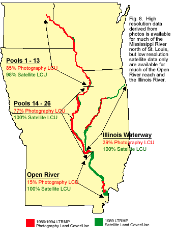 A systemic HNA Areas GIS database was developed from existing data to
standardize geomorphic area (location in the river system) and land cover
(plant communities and land use) classification systems (Fig. 8). The
GIS database defines various aquatic areas, islands, and contiguous and
isolated floodplain areas, as well as 17 ecologically relevant land cover
classes. Aquatic habitat areas were further described using spatial data
about proximity to shorelines, wing dams, and closing dams. The 1989 HNA
land cover GIS database also includes boundaries for EMP habitat project
areas. Links to habitat project fact sheets provide information on project
goals and objectives.
A systemic HNA Areas GIS database was developed from existing data to
standardize geomorphic area (location in the river system) and land cover
(plant communities and land use) classification systems (Fig. 8). The
GIS database defines various aquatic areas, islands, and contiguous and
isolated floodplain areas, as well as 17 ecologically relevant land cover
classes. Aquatic habitat areas were further described using spatial data
about proximity to shorelines, wing dams, and closing dams. The 1989 HNA
land cover GIS database also includes boundaries for EMP habitat project
areas. Links to habitat project fact sheets provide information on project
goals and objectives.
Habitat: Species Relationships
The UMR supports a large number of species including: over 200 aquatic
macroin-vertebrate species, 44 mussel species, 143 fish species, 73 reptile
and amphibian species, over 300 bird species, and over 50 mammal species,
in addition to the hundreds more plant, insect, and microbe species. This
large number of species was organized by combining species of aquatic
macroinver-tebrates, mussels, fish, reptiles and amphibians into groups
of animals, called guilds, that have similar habitat requirements and
habitat use. Birds, mammals, reptiles and amphibians, and some fish are
considered at the species level because much is known of their life history.
Relational tables were developed to link species and guilds with the
HNA Areas GIS database (Table 2). These relational tables provide a coarse
system-wide overview of habitat areas that have the potential to support
different species and guilds. Potential habitat for species and guilds
was rated by regional experts using a 0 to 3 score:
- 0 = very low potential occurrence,
- 1 = low potential occurrence,
- 2 = moderate potential occurrence,
- 3 = high potential occurrence.
| Guild |
Habitat Modifiers
(1 or 0)
|
Aquatic
|
|
main
|
secondary
|
tertiary
|
tributary
|
excavated
|
|
nav channel
|
channel border
|
tail
water
|
|
|
|
|
|
shore
line
|
wing dam
|
rip-rap
|
|
| Lotic Aquatic Salamanders |
0
|
1
|
1
|
0
|
2
|
3
|
2
|
1
|
2
|
0
|
| Lentic Aquatic Salamanders |
1
|
0
|
0
|
0
|
0
|
0
|
0
|
0
|
1
|
0
|
| Terrestrial Salamanders |
1
|
0
|
0
|
0
|
0
|
0
|
0
|
0
|
0
|
0
|
| Terrestrial Frogs and Toads |
1
|
0
|
0
|
0
|
1
|
0
|
1
|
1
|
2
|
1
|
| Semi-Aquatic Frogs |
1
|
0
|
1
|
0
|
2
|
1
|
2
|
2
|
1
|
2
|
| Aquatic Frogs |
1
|
0
|
1
|
0
|
2
|
2
|
3
|
3
|
3
|
3
|
| Arboreal Frogs |
1
|
0
|
0
|
0
|
0
|
0
|
0
|
0
|
0
|
0
|
| Lentic Turtles |
1
|
1
|
1
|
1
|
2
|
1
|
3
|
1
|
2
|
2
|
| Lolic Turtles |
1
|
1
|
1
|
1
|
3
|
2
|
3
|
1
|
2
|
1
|
| Terrestrial Turtles |
1
|
0
|
0
|
0
|
1
|
0
|
0
|
0
|
1
|
0
|
| Woodland Lizards |
1
|
0
|
0
|
0
|
2
|
0
|
2
|
2
|
2
|
0
|
| Prarie Lizards |
1
|
0
|
0
|
0
|
1
|
0
|
1
|
0
|
1
|
0
|
| Woodland Snakes |
1
|
0
|
0
|
0
|
1
|
0
|
1
|
0
|
2
|
0
|
| Prarie Snakes |
1
|
0
|
1
|
0
|
1
|
0
|
1
|
1
|
2
|
1
|
| Aquatic Snakes |
1
|
1
|
1
|
0
|
3
|
1
|
3
|
1
|
2
|
1
|
Table 2. Example of reptile and amphibian guild-by-habitat relation
table.
Table 2 (cont.). Example of reptile and amphibian guild-by-habitat
relation table.
| Guild |
Backwater
|
Terrestrial
|
|
contiguous
|
isolated |
islands |
floodplain
|
|
FP lake
|
shallow AQ
|
impounded
|
|
|
contiguous
|
isolated
|
| Lotic Aquatic Salamanders |
0
|
0
|
1
|
0
|
0
|
0
|
0
|
| Lentic Aquatic Salamanders |
1
|
3
|
1
|
3
|
2
|
3
|
1
|
| Terrestrial Salamanders |
0
|
0
|
0
|
3
|
0
|
3
|
1
|
| Terrestrial Frogs and Toads |
2
|
3
|
2
|
3
|
0
|
3
|
3
|
| Semi-Aquatic Frogs |
3
|
3
|
2
|
3
|
1
|
3
|
3
|
| Aquatic Frogs |
3
|
1
|
3
|
2
|
2
|
3
|
3
|
| Arboreal Frogs |
1
|
1
|
1
|
3
|
0
|
1
|
2
|
| Lentic Turtles |
3
|
1
|
3
|
2
|
3
|
3
|
2
|
| Lolic Turtles |
3
|
1
|
2
|
0
|
2
|
2
|
0
|
| Terrestrial Turtles |
1
|
1
|
1
|
1
|
0
|
3
|
3
|
| Woodland Lizards |
1
|
0
|
2
|
2
|
0
|
2
|
3
|
| Prarie Lizards |
0
|
0
|
0
|
0
|
0
|
2
|
3
|
| Woodland Snakes |
1
|
1
|
1
|
1
|
0
|
2
|
1
|
| Prarie Snakes |
2
|
3
|
3
|
3
|
0
|
3
|
3
|
| Aquatic Snakes |
3
|
1
|
2
|
2
|
1
|
3
|
1
|
|
|
HNA Query Tool
The HNA GIS Query Tool was developed to assist the Habitat Needs Assessment.
It helps evaluate potential distribution of species and habitat area types
throughout the UMRS.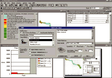 The user may query on a species and obtain habitat information, or may
query on a habitat to obtain species information. These queries are accomplished
using the matrices developed to associate a species’ potential to
occur within various types of habitat. The query tool presently incorporates
land cover and geomorphic area data. An advanced version of the tool incorporates
more data layers to define habitat in more detail and to create better
habitat models. Application of the advanced tool is presently limited
because spatial data about habitat attributes needed to use it to its
full capability are still lacking for most of the river system. The HNA
GIS Query Tool was designed to generate information about user-specified
species, guilds, or habitats for selected portions of the UMRS. This includes
the production of GIS themes, tables, charts, maps, and text reports describing
potential species habitat, occurrence, and diversity.
The user may query on a species and obtain habitat information, or may
query on a habitat to obtain species information. These queries are accomplished
using the matrices developed to associate a species’ potential to
occur within various types of habitat. The query tool presently incorporates
land cover and geomorphic area data. An advanced version of the tool incorporates
more data layers to define habitat in more detail and to create better
habitat models. Application of the advanced tool is presently limited
because spatial data about habitat attributes needed to use it to its
full capability are still lacking for most of the river system. The HNA
GIS Query Tool was designed to generate information about user-specified
species, guilds, or habitats for selected portions of the UMRS. This includes
the production of GIS themes, tables, charts, maps, and text reports describing
potential species habitat, occurrence, and diversity.
|
Forecast Future Conditions
Quantitative Assessment of Forecast Geomorphic Change
A review of published reports was used to characterize forecast geomorphic
changes in the UMRS over the next 50 years. The Cumulative Effects Study,
completed for the Upper Mississippi River–Illinois Waterway Navigation
Feasibility Study, was the most recent attempt to quantify a forecast
of future conditions for the UMRS. The Cumulative Effects study team compiled
historic maps, photos, channel bathymetry, sediment transport estimates,
dredging statistics, and many other data to assess apparent geomorphic
changes resulting from and incurred since impoundment to help predict
plan form change over the next 50 years. The review was more comprehensive
in Pools 4 – 26 than in the rest of the river system.
Qualitative Assessment of Site-Specific Geomorphic Change
Two methods were used to provide a qualitative site-specific assessment
of geomorphic change. Both methods incorporated an analysis of historic
change to predict future conditions. The first assessment was completed
as part of the Cumulative Effects Study, in which the consultant team
reviewed historic maps and photos to identify areas of extensive change.
Using this method, only large plan form changes were detectable. The second
method incorporated the knowledge and experience of natural resource managers,
many with 20 or more years of experience working in specific regions of
the river. Workshops were held to have managers locate areas showing past
change or expected to change in the next 50 years on maps. The manager’s
local knowledge allowed a more detailed analysis because they could provide
insight into changes occurring below the water’s surface. For example,
backwaters that may not have displayed discernable change in surface area
may have lost significant depth that reduced their value as habitat.
Floodplain Vegetation Successional Model
A terrestrial vegetation successional model was developed to help predict
land cover change. A rule-based approach was employed to estimate the
system-wide percent change of one land cover class to other land cover
classes over a fifty-year time period. An expert panel of Upper Mississippi
River System foresters, botanists, and ecologists was convened to develop
the rule based successional model. The panel first agreed on the set of
plant community types to be included in the analysis. The panel also agreed
on a set of assumptions that would limit the range of future change under
consideration. The assumptions include:
- Land presently in agricultural use will remain in agricultural use,
- Developed land will remain developed,
- Existing plans for floodplain vegetation management will be implemented,
- The climate and hydrologic regime will not change,
- The present set of natural disturbances (wind, fire, flood, ice,
diseases, etc.) will continue.
The panel then developed the basic pathways for change from early successional
classes to later successional classes. A smaller team estimated the proportion
of each land cover anticipated to change to other land cover classes using
terrestrial area change estimates from the Cumulative Effects Study where
available. The calculations were conducted at the pool scale and summarized
in the HNA technical report appendices. Locations of change were not predicted.
|
Desired Future Habitat Conditions
|
Consultations With Resource Managers Workshops were held
to consider historic conditions, existing conditions, the available
forecast of future conditions, and ongoing geomorphic processes
to ultimately identify desired future habitat conditions. Information
developed previously to assess historic, existing, and predicted
UMRS plan form habitat changes was distributed to participants in
advance of the workshops. A qualitative assessment asked five questions
to elicit responses important to assessing:
- the quality of the approach and information used in the description
of historic, present, and predicted habitat,
- desired habitat quality,
- areas, processes, species, or habitat characteristics critical
to maintaining habitat integrity,
- threatened habitats, and
- stressors or altered disturbance regimes limiting restoration
potential.
|
 |
| Lake Chautauqua, Illinois River, inside of the restoration
project. |
 |
| Lake Chautauqua, Illinois River, outside of the restoration
project. |
|
In an effort to quantify desired future habitat conditions, resource
managers expressed their professional opinion regarding the proportion
of geomorphic area classes in "desirable" condition for the
present, predicted future and desired future. These percentages were then
transformed into an approximation of "desirable" acres needed
for each geomorphic area type.
|
Public Involvement
Public involvement was recognized as a vital part of the Habitat Needs
Assessment process. During this first HNA, several approaches were developed
by a multi-agency HNA Public Involvement Team to assess the public’s
understanding, values, and expectations regarding desired future habitat
conditions for the UMRS. These approaches were by no means comprehensive,
but were considered to be the most practical and effective means of engaging
the public in the initial HNA.
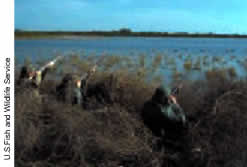 |
| Fall waterfowl hunting is popular throughout the river
system. |
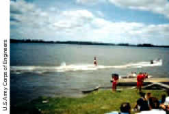 |
| Water skiing near Grafton, Illinois. |
|
Information was collected from the public at two levels: institutions,
and the public at large. A compilation of mission statements and
UMRS management plan objectives were reviewed to identify institutional
priorities and activities related to river habitat. A series of
12 open public meetings conducted in April and May 1999 and a series
of ten focus group meetings conducted in July and August 2000 were
used to assess the general public’s understanding, values,
and expectations regarding desired future UMRS habitat conditions.
Information from governmental and non-government organizations
with interests in and responsibilities for habitat management in
the UMRS were obtained to identify institutional intent with respect
to UMRS habitat. The institutional intent was evaluated by examining
the mission statements of agencies and organizations, resources
identified as being important or as the target of management activities,
and statements in management plans about UMRS habitat.
|
During April and May 1999, the National Audubon Society and Upper Mississippi
River Conservation Commission convened public meetings at 12 locations
on the Upper Mississippi River System. Maps showing local river resources
were provided prior to the formal program portion of each meeting. Following
two informative presentations about the condition of the river system,
meeting participants were invited to respond to the following questions:
- What are the important natural resources in the Mississippi (Illinois)
River ecosystem?
- What do you think are the problems and opportunities in the river
ecosystem?
- How will you recognize successful restoration of the river ecosystem?
Focus groups convened by the U.S. Fish and Wildlife Service, U.S. Army
Corps of Engineers, and the Upper Mississippi River Basin Association
were the second method used to obtain public views of UMRS resources and
the HNA process. Various river interests were reflected in the 92 focus
group participants, including perspectives from environmental groups,
industrial and transportation groups, fishers and hunters, landowners,
and river residents. A presentation on the HNA process and results was
followed by facilitated discussions on three points developed by the HNA
Public Involvement team:
- to gauge public reaction to details of the HNA process;
- to capture public perspectives of desired future habitat conditions;
and
- to capture perspectives and preferences for future public involvement
in the HNA/EMP process.
|


