Land Cover
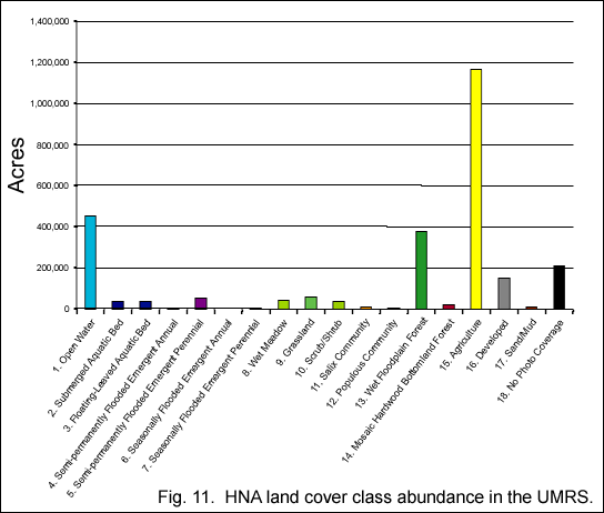
The Upper Mississippi River System floodplain area encompasses over 2.6
million acres (Fig. 11). Agriculture is the dominant land cover class,
occupying about 50 percent of the floodplain. Open water is the second
dominant land cover class, covering 17 percent of the floodplain. Floodplain
forests follow closely, occupying 14 percent of the floodplain. None of
the other classes exceeds 10 percent of the floodplain area, and only
developed land areas exceed 5 percent.
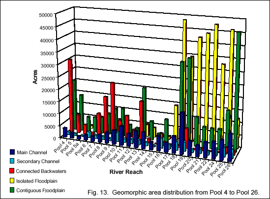
Land cover classes are unevenly distributed throughout the river system,
and the absolute floodplain area of river reaches and pools may also differ
greatly (Fig. 12). The largest differences occur in the amount and distribution
of agriculture and the proportion of open water in the floodplain. Agriculture
dominates the floodplain south of Rock Island, Illinois (Pool 14), and
open water occupies a greater proportion of the floodplain between Minneapolis
(Pool 1) and Clinton, Iowa (Pool 13). Wetland classes are generally more
abundant between Minneapolis and Clinton. Grasslands are fairly evenly
distributed but are rare throughout the river system. Woody classes are
important throughout the river system and generally occupy between 10
to 20 percent of the floodplain.
Floodplain and Aquatic Areas
Geomorphic areas, or aquatic and terrestrial features within river reaches,
are parts of the river system that have similar geologic origins, formed
by similar river processes or manmade structures. They include channel,
backwater, and floodplain areas. Aquatic areas are either contiguous (connected
with the river) or isolated (normally not connected with the river). Similarly,
floodplain areas are either contiguous or isolated from the river by levees.
The geomorphic area data are limited to Upper Mississippi River Pools
4 through 26, the La Grange Pool, and the Cape Girardeau LTRMP study reach.
The summary of the reach from Lake Pepin to St. Louis, Missouri shows
that about 40 percent of the total floodplain area (including both aquatic
and floodplain areas) is leveed, but levees are concentrated south of
Rock Island, Illinois (Fig. 13). This figure closely approximates the
amount of agriculture in the floodplain. The distribution of leveed areas
as proportion of total floodplain area is about:
- 3 percent north of Pool 13;
- 50 percent from Pool 14 through Pool 26;
- 80 percent in the Open River; and
- 60 percent of the lower 160 miles of the Illinois River.
Contiguous floodplain susceptible to seasonal flooding constitutes about
23 percent of the floodplain area system-wide. Islands are about 8 percent
of the floodplain area, bringing the total terrestrial area to about 70
percent of the floodplain from Minneapolis to St. Louis.
The range of the proportional contribution of aquatic area types was
10 to 70 percent of the total river floodplain area, which is indicative
of the geomorphic variability among river reaches and the differing effects
resulting from impoundment. Backwater aquatic area classes are more prominent
in the northern pooled reaches, and channel habitats are more prominent
in the southern pooled reaches. Overall:
- channel border is 6.6 percent of the total area,
- impounded area is 4.6 percent,
- contiguous backwaters are 3.9 percent,
- secondary channels are 3.7 percent,
- navigation channel is 3.2 percent,
- shallow aquatic area is 2.8 percent,
- and isolated backwaters are 2.0 percent.
Tailwaters, tertiary channels, tributary channels, and excavated channels
are 0.2 percent or less of the total floodplain area, respectively.
|


