Upper Midwest Environmental Sciences Center
|
|

HNA Summary Report
Existing
Conditions
Terrestrial
Habitat Distribution
|
|
It is useful to examine the patterns of landscapes when assessing their
ability to support desirable animal communities. An analysis of long-term
change in several broad habitat classes helps assess general change over
time. When examining existing conditions, or managing for discrete habitat
or species, attention to fine details of habitat may be more appropriate.
|
|
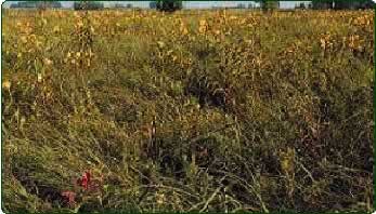
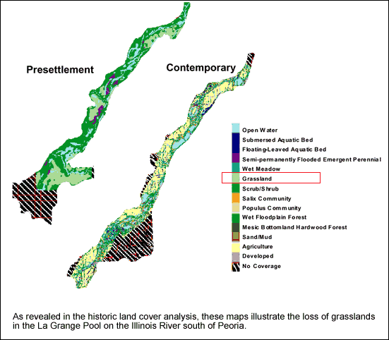
Grassland
 The
review of historic ecological change presented earlier clearly demonstrates
the loss of grassland land cover from Iowa to southern Illinois. The extent
of grassland fragmentation and conversion are the most extreme changes
in many parts of the UMRS. Grassland patch connectivity has been highly
reduced, and connectivity to other natural habitats has been reduced where
agriculture or development are adjacent to grassland patches. The
review of historic ecological change presented earlier clearly demonstrates
the loss of grassland land cover from Iowa to southern Illinois. The extent
of grassland fragmentation and conversion are the most extreme changes
in many parts of the UMRS. Grassland patch connectivity has been highly
reduced, and connectivity to other natural habitats has been reduced where
agriculture or development are adjacent to grassland patches.
|
 |
|
Forest
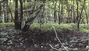 Forest
was and remains an important component of the floodplain landscape for
many reptile, amphibian, bird, and mammal species. Contemporary forests
are distributed differently and have different species composition than
in the past. They are even aged and have low tree species diversity. Changes
in response to river and floodplain development differ among geomorphic
reaches. Floodplain forests in northern pooled reaches were replaced mostly
by water impounded by dams and also by development. Forests remaining
in the upper pooled reaches have species composition similar to the past.
In the southern pooled reaches, the lower Illinois River, and the Open
River south to the Kaskaskia River, open forests and grassland-oak savannas
joining dense riparian forests and grasslands were eliminated, but riparian
forests remain largely intact. In the Open River south of the Kaskaskia
River, the floodplain was once almost completely forested, but was later
cleared and levees were constructed to protect crops. Forest
was and remains an important component of the floodplain landscape for
many reptile, amphibian, bird, and mammal species. Contemporary forests
are distributed differently and have different species composition than
in the past. They are even aged and have low tree species diversity. Changes
in response to river and floodplain development differ among geomorphic
reaches. Floodplain forests in northern pooled reaches were replaced mostly
by water impounded by dams and also by development. Forests remaining
in the upper pooled reaches have species composition similar to the past.
In the southern pooled reaches, the lower Illinois River, and the Open
River south to the Kaskaskia River, open forests and grassland-oak savannas
joining dense riparian forests and grasslands were eliminated, but riparian
forests remain largely intact. In the Open River south of the Kaskaskia
River, the floodplain was once almost completely forested, but was later
cleared and levees were constructed to protect crops.
|
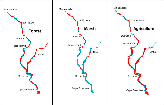
The land cover type is highlighted in red in the images above, indicating
each land cover's relative distribution throughout the UMRS. |
|
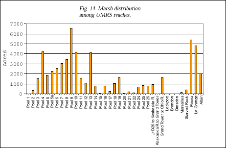
Marsh
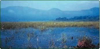 Marsh
fragmentation is difficult to assess because river marshes were not well
mapped in early periods and they are inherently fragmented along backwater
margins, wet meadows, and river banks. Generally, contemporary marsh communities
are more abundant in northern river reaches than in southern reaches,
where there are few backwaters, river water is turbid, and sediment quality
is poor. Marsh patches are so small and widely separated in southern river
reaches that they can barely even be seen at this map scale. There is
greater absolute acreage of marsh habitat in northern pooled reaches,
and the proportion of total floodplain area is very much greater, because
the northern reaches have less total area than southern reaches (Fig.
14). In other words, marsh habitats are more abundant, widely distributed,
and common in northern river reaches. Marsh
fragmentation is difficult to assess because river marshes were not well
mapped in early periods and they are inherently fragmented along backwater
margins, wet meadows, and river banks. Generally, contemporary marsh communities
are more abundant in northern river reaches than in southern reaches,
where there are few backwaters, river water is turbid, and sediment quality
is poor. Marsh patches are so small and widely separated in southern river
reaches that they can barely even be seen at this map scale. There is
greater absolute acreage of marsh habitat in northern pooled reaches,
and the proportion of total floodplain area is very much greater, because
the northern reaches have less total area than southern reaches (Fig.
14). In other words, marsh habitats are more abundant, widely distributed,
and common in northern river reaches.
|
 |
|
Agriculture
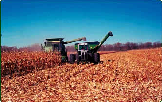 Croplands
currently occupy about one-half of the total UMRS floodplain area, and
agriculture is the dominant land cover class. Cropland distribution is
skewed toward southern river reaches where levees protect the wide fertile
floodplains. Agriculture is the largest continuous land cover class in
the lower 500 miles of the Upper Mississippi River and the lower 200 miles
of the Illinois River. Grasslands once occupied most of the current agricultural
land, but forested areas were also converted to crops. Croplands
currently occupy about one-half of the total UMRS floodplain area, and
agriculture is the dominant land cover class. Cropland distribution is
skewed toward southern river reaches where levees protect the wide fertile
floodplains. Agriculture is the largest continuous land cover class in
the lower 500 miles of the Upper Mississippi River and the lower 200 miles
of the Illinois River. Grasslands once occupied most of the current agricultural
land, but forested areas were also converted to crops.
|
|


