Upper Midwest Environmental Sciences Center
|
|

HNA Summary Report
The Role
of Disturbance in the UMRS Ecosystem
|
|
Large rivers are dynamic ecosystems where habitats evolved and
persist in response to a variety of natural and human-caused disturbances
(see Table 1). Floods and droughts are natural disturbances that
occur seasonally, but exhibit an approximately decadal cycle of
extreme events on the UMRS. Seasonal flooding drives a highly productive
and diverse ecosystem.
Sediment transport and channel-forming processes are active continuously.
Channel and floodplain geometry can change slowly over a period
of decades or rapidly during extreme floods. Impoundment and river
regulation for navigation have significantly modified the hydrologic
regime and the pattern of sedimentation.
|
|
Table 1. Ecological Disturbances
|
| Natural |
Man Made |
Flood
Drought
Sedimentation
Channel migration
Sediment resuspension
Fire
Ice shear
Tree wind-throw
Log jam
Beavers |
Water level regulation
Dredging and dredged
material disposal
Channel training structures
Boat generated waves
Levee construction
Agriculture
Nutrient enrichment
Logging
Urban development
Contaminants
|
|
|
|
|
|
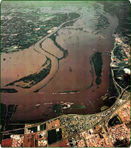
The great flood of 1993 was one of the country’s
worst disasters.
|
|
Fire was once a dominant force maintaining floodplain grassland-savanna
landscapes. Ice flows, tree falls, and log jams are all natural
occurrences that help define local habitats and maintain high habitat
diversity. Biological disturbances (e.g., beavers) are important
in the development of floodplain landscapes.
Impoundment, water level regulation, channelization, levee construction,
logging, and urban and agricultural development are the dominant
human activities affecting river habitats on the UMRS. Navigation
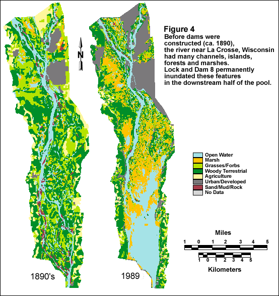
dams converted free flowing rivers to a series of shallow impoundments.
Portions of the floodplain were permanently flooded by the dams
and backwater area increased significantly in some river reaches
(Fig. 4). Since impoundment, sedimentation of backwaters, island
loss, and loss of secondary channels have greatly modified the pattern
of river habitats.
|
|
|
|
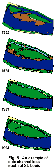 Rock
wing dams, closing dams, and bank revetments are used to maintain the
navigation channel and to reduce dredging requirements. These structures
decrease bank erosion and force flow into the main river channel. In the
Open River reach, channel training structures have greatly reduced the
number and quality of secondary channels (Fig. 5). There has also been
loss of channel area as sediment filled the area between wing dams. Rock
wing dams, closing dams, and bank revetments are used to maintain the
navigation channel and to reduce dredging requirements. These structures
decrease bank erosion and force flow into the main river channel. In the
Open River reach, channel training structures have greatly reduced the
number and quality of secondary channels (Fig. 5). There has also been
loss of channel area as sediment filled the area between wing dams.
Much of the floodplain south of Pool 16 on the Mississippi River and
on the La Grange and Alton pools on the Illinois River has been isolated
by levees. The distribution of levees as proportion of total floodplain
area is about:
- 3 percent north of Pool 13;
- 50 percent from Pool 14 through Pool 26;
- 80 percent in the Open River; and
- 60 percent of the lower 160 miles of the Illinois River.
In total, more than 1.1 million acres, mostly agricultural land, are
protected from moderate floods by levees.
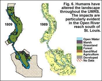
Logging has caused significant habitat degradation throughout the river
floodplains and northern parts of the basin. Logging was necessary to
supply fuel-wood for steamboats and railroads, firewood for heat and cooking,
and lumber to build cities. In most floodplain areas deforested land was
rapidly converted to agriculture. The impact is particularly dramatic
below the Kaskaskia River where the densely forested floodplain was almost
completely cleared (Fig. 6). Deforestation and agricultural conversion
throughout the basin increased sediment delivery to the mainstem rivers.
|
|
 Urban
development displaced native habitats, but also caused indirect impacts.
Sewage and industrial pollution caused significant water quality problems
that eradicated sensitive species downstream of large cities. The problem
has subsided since the 1970s. Urban
development displaced native habitats, but also caused indirect impacts.
Sewage and industrial pollution caused significant water quality problems
that eradicated sensitive species downstream of large cities. The problem
has subsided since the 1970s.
|
| |