
 |
Upper Mississippi River Restoration ProgramLong Term Resource Monitoring |
|
 |
||
Long Term Resource Monitoring Program Water Quality Graphical Browser Help Page - Fixed Sites
Note: a separate graphical browser is available for LTRMP stratified random sampling data.
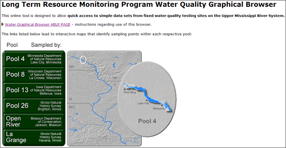
The LTRMP Water Quality Graphical Browser is an online tool designed to allow quick access to simple data sets from fixed water quality testing sites on the Upper Mississippi River System.
The following is an overview of how to use the product:
 Step 1.
Select one of the Upper Mississippi River (UMR) pools listed in the menu:
- Mouse-over a link to preview the pool.
- Click on a link to open an graphical interface listing the fixed sampling sites for water quality within the selected pool.
 Step 2.
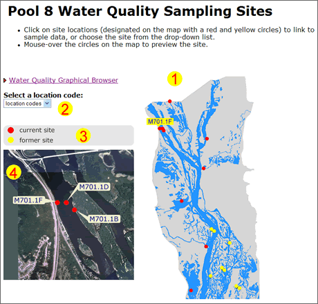
The graphical interface for each UMR pool has these common elements:
- A map of the pool with red and yellow markers (links) designating fixed site locations:
- Mouse-over markers to preview site locations (#4).
- Click on markers to open linked documents with site specific information.
- All test sites are also linked from a drop-down list.
- A legend indicates each site's status as "current", where we collect data now, or "former", where we no longer collect data.
- Mouse-over any red or yellow marker in the pool map (#1) to display an aerial view of the site location.
 Step 3.
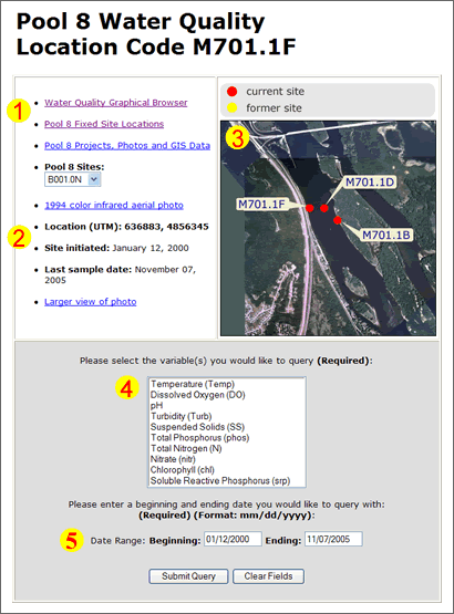
Each site specific interface contains these similar elements:
- Links to the main tools within the LTRMP Water Quality Browser.
- Information related to the specific site location.
- UTM
- Site initiated date
- Last sample date
- An aerial view of site location
- A form to search for data from the specific site location:
- Data type - Temperature, Dissolved Oxygen, PH, Turbidity, Suspended Solids, Total Phosphorous, Total Nitrogen, Nitrate, Chlorophyll, Soluble Reactive Phosphorous.
- Hold Ctrl button for multiple selections.
- Choose the beginning and ending dates for the date (default is first and last sample dates for the site). Submit the query to generate output.
 Step 4.
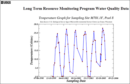
The final output is generated based upon the parameters submitted in the form. The information is provided in two formats:
- A graph displays the requested data with the sampling date on the x-axis.
- A link to the raw data used to generated by the graph request is included below the graph.
NOTES:
- Not all variables were collected at all sites or all times. Thus, for some combinations of sites, variables and time period, your search results may indicate that no data were found.
- Printed data may occasionally contain negative values. These indicate that results of analyses were below detection limits. Negative values are not plotted or graphed.

Page Last Modified: December 31, 2012