
 |
Upper Mississippi River Restoration ProgramLong Term Resource Monitoring |
|
| |
||
Floodplain Forest Data |

Foreword
The data were collected in a survey of the floodplain forests in selected reaches along the Upper Mississippi and Illinois Rivers conducted in summer 1994. The survey was conducted to estimate tree mortality induced by the Flood of 1993.
Summary
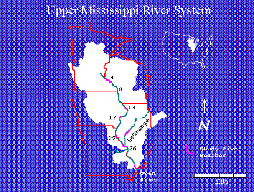
Surveyed Reaches and Cooperating Agencies
| River/Reach | Cooperating Agency |
|---|---|
| UMR/Pool 4 | Minnesota Department of Natural Resources |
| UMR/Pool 8 | Wisconsin Department of Natural Resources |
| UMR/Pool 13 | Iowa Department of Natural Resources |
| UMR/Pool 17 | Department of the Army, Engineer District, Rock Island Natural Resource Management Section |
| UMR/Pool 22 | Department of the Army, Engineer District, Rock Island Natural Resource Management |
| UMR/Pool 26 | Illinois Natural History Survey |
| UMR/Open River RM (30–80) | Missouri Department of Conservation |
| ILL/La Grange Pool | Illinois Natural History Survey |
UMR = Upper Mississippi River, ILL = Illinois River
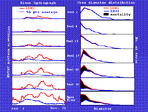
Hydrographs and Tree/Sapling Distance at Breast Height Distributions
Special Attention
In the Long Term Resource Monitoring Program procedures manual, trees are defined as woody stems (excluding vines) 10 cm or greater diameter at breast height (DBH) and saplings are defined as woody stems (excluding vines) 2.5 to 9.9 cm DBH. These definitions were adapted when data were collected in Pools 4, 8, 13, 17, 22, and 26, and the Open River along the Upper Mississippi River. Because of an error made by the field crew, these definitions were altered when data were collected in the Havana reach of the Illinois River. At Havana, trees were defined as woody stems (excluding vines) that were at least 10 cm in diameter and whose crown were in the canopy layer; saplings were defined as woody stems (excluding vines) that were in the understory but were 2.5 cm or greater DBH.
Reference
Yin, Y., and J. C. Nelson. 1995. Modifications to the Upper Mississippi River and their effects on floodplain forests. National Biological Service, Environmental Management Center, Onalaska, Wisconsin, February 1995. LTRMP 95-T003. 17 pp.
Disclaimer
These data have been generated by State agencies under contract with the Department of the Interior and the Upper Midwest Environmental Sciences Center (UMESC). Although these data have been processed successfully on a computer system at the UMESC, no warranty, expressed or implied, is made regarding the accuracy or utility of the data on any other system or for general or scientific purposes, nor shall the act of distribution constitute any such warranty. However, error correction is a continuing process, and the UMESC routinely makes changes to data as errors are discovered. The file date is referred to as the release date and should be mentioned in all references to data. These data have been provided as a unit package to ensure that you receive a valid data set collected in a consistent manner. Methods, purposes, and conditions can vary dramatically among data-collecting efforts and these data should not be combined with other data sets from the UMESC or other sources unless the user fully understands the procedures and purposes used to create each set of data and can verify that data are comparable across sources.

Page Last Modified: May 7, 2018