

Upper Midwest Environmental Sciences Center
Long Term Resource Monitoring Program Spatial Data Query and Visualization Tool
|
Ongoing Upper Midwest Environmental Sciences Center (UMESC) activities relating to public access to Long Term Resource Monitoring Program (LTRMP) data stem from provisions contained in the Water Resources Act of 1986. In that Act, Congress recognized the Upper Mississippi River System (UMRS) as both a nationally significant ecosystem and a nationally significant commercial navigation system. Accordingly, the mission of the LTRMP is to provide decision makers with the information needed to maintain the Upper Mississippi River System as a viable multiple-use large river ecosystem. An application, the LTRMP Spatial Data Query and Visualization Tool, (Query Tool) is being developed to facilitate the dissemination, display, and querying of Upper Mississippi River Basin (UMRB) data sets. Meetings and workshops to define the requirements and refine the scope of work for the Query Tool are in progress. |
 |
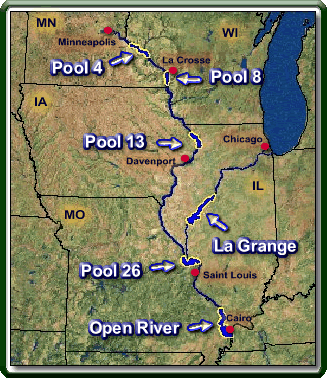 |
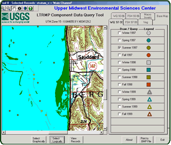
LTRMP Component Data Query Tool ModuleThe UMESC stores point-sampled data for fish, water quality, and invertebrates in a relational database management system. These component data are collected at fixed and random sites in each of the key LTRMP study Pools: 4, 8, 13, 26, and the Open River Reach on the Mississippi River; and La Grange Pool on the Illinois River. While the geographic locations of these data are also collected and stored, the tools to automate the integration of these data with spatial data were not previously developed as a stand-alone desktop application. The Query Tool is a desktop application for Microsoft Windows 98 or later versions requiring no additional software to use. |
The Query Tool integrates the LTRMP component data with spatial data layers by allowing the user to overlay sampling point locations on basemap layers, such as land/water, landcover/use, and U.S. Geological Survey quadrangles and graphically or logically select sampling sites and their corresponding records. The application features an easy-to-use graphical user interface and requires only basic computer knowledge to use effectively. The user can pan and zoom, turn on and off basemap and sampling site layers, save images to the Windows bitmap (.bmp) format, and output selected database records to an ASCII file for analysis in other applications.
 |
Although the LTRMP Component Data Query Tool was designed to be
as simple to use as possible, it does require a fundamental understanding
of geographic information system (GIS) concepts and terminology,
basic relational database theory, and an understanding of the LTRMP
component database structure and sampling methodologies. For a detailed
description of the LTRMP component database structure and sampling
methodologies, see LTRMP Program Report 97-P010
"Long Term Resource Monitoring Program Component |
Summary
This is the first in a series of modules that will comprise the LTRMP Spatial Data Query and Visualization Tool. We are confident that an easy-to-use display and query tool for Windows 98 and later versions that is accessible by all users familiar with Microsoft Windows applications and basic spatial concepts will finally allow all users the GIS display and query functionality that has been lacking.
The LTRMP is committed to making our data accessible to every computer user—not just the GIS technical staffers. Your feedback is needed to ensure that these tools are as useful as possible to the broadest possible audience. We view this process as iterative, with this beta version being only the beginning of a process whereby you, the user, define the requirements for the tools we build.
Project will be completed in May 2003.
This product can be distributed on CD-ROM or downloaded from the UMESC
web site at http://umesc.usgs.gov/data_library/tools/spatial_query.html.
