|
|

HNA Summary Report
Habitat
|
|
A habitat is an organism's "home." Defining the characteristics
of the "home" for a host of river species is challenging. 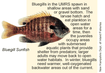 Many
species may also have different habitat needs at different life stages
and times of year (see sidebar). Habitat can be described in different
levels of detail to narrow down the potential areas that may be occupied
by an organism of interest. First, larger geographic areas and land cover
types can be used. Next, other relevant attributes of habitat, such as
current velocity, water depth, forest community type, etc. can be applied.
For this HNA, habitats have been characterized broadly at the first level
using floodplain land cover and aquatic area types. The "habitats"
thus defined may be quite large, of low resolution, and only generally
identify where species are likely to occur. Future refinements of this
HNA will include additional physical and chemical habitat attributes and
will define habitat for individual species in greater detail. Many
species may also have different habitat needs at different life stages
and times of year (see sidebar). Habitat can be described in different
levels of detail to narrow down the potential areas that may be occupied
by an organism of interest. First, larger geographic areas and land cover
types can be used. Next, other relevant attributes of habitat, such as
current velocity, water depth, forest community type, etc. can be applied.
For this HNA, habitats have been characterized broadly at the first level
using floodplain land cover and aquatic area types. The "habitats"
thus defined may be quite large, of low resolution, and only generally
identify where species are likely to occur. Future refinements of this
HNA will include additional physical and chemical habitat attributes and
will define habitat for individual species in greater detail.
|
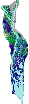 |
The higher level land cover classes are floodplain
forest, grassland, marsh, developed, and agriculture. Forest and
marsh are further separated into four classes each, and several
additional aquatic classes create 17 total land cover classes (left).
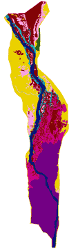
Geomorphic areas describe physical habitats in the river floodplain
system (right). The highest level geomorphic classification separates
aquatic and terrestrial areas. Terrestrial areas include islands
and connected and isolated floodplain areas. Aquatic areas are separated
into several channel and backwater classes. The main channel and
channel border areas convey the greatest river flow. Secondary channels
and tertiary channels are typically flowing habitats, but the amount
of flow is quite variable depending on their location in the river
system and their connectivity with the main channel. Backwater areas
may be connected or isolated. In some areas, the dams create large
contiguous impounded backwaters and shallow aquatic areas.
|
 |
| For a detailed view of UMRS Pool 8 LCU classifications,
click on the image above. |
For a detailed view of UMRS Pool 8 geomorphic
classifications, click on the image above. |
|
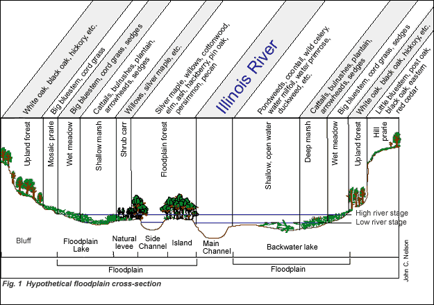
River floodplain ecosystems support a wide variety of species, which
are distributed along flood frequency gradients (see Fig. 1 above). Low
elevation floodplain areas, which are usually inundated, support aquatic
and wetland plants. Areas subject to frequent flooding support flood tolerant
species. The least flood tolerant plant species occur on well-drained,
high elevation areas. Flooding is the major disturbance on low elevation
floodplains. Fire was once an influence on high elevation floodplains,
but fires have been suppressed and agriculture is currently the major
influence.
|
|
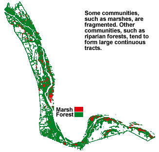 Habitat
classification systems can be quite complex, and so can the analytical
tools used to investigate the charac-teristics of habitat. Three important
habitat characteristics used in the relatively young sciences of landscape
and conservation ecology were incorporated into the HNA. Habitat fragmentation
is a measure of the size of continuous blocks, or patches, of plant species
or communities (see image at left). Habitat connectivity is the consideration
of organisms’ ability to move through a landscape to fulfill its
normal life cycle (see image below). Some organisms have limited mobility,
and rely on wind, water, or other animals for dispersal of seeds or young.
Other more mobile species, particularly fish, are restricted in their
movements within the river system by dams and levees. At the other end
of the spectrum, birds are generally highly mobile and can traverse obstacles
that present barriers to other species. Habitat
classification systems can be quite complex, and so can the analytical
tools used to investigate the charac-teristics of habitat. Three important
habitat characteristics used in the relatively young sciences of landscape
and conservation ecology were incorporated into the HNA. Habitat fragmentation
is a measure of the size of continuous blocks, or patches, of plant species
or communities (see image at left). Habitat connectivity is the consideration
of organisms’ ability to move through a landscape to fulfill its
normal life cycle (see image below). Some organisms have limited mobility,
and rely on wind, water, or other animals for dispersal of seeds or young.
Other more mobile species, particularly fish, are restricted in their
movements within the river system by dams and levees. At the other end
of the spectrum, birds are generally highly mobile and can traverse obstacles
that present barriers to other species.
|
Habitat diversity is a measure of the mix of species or communities
present in a given area. Low diversity habitats have large expanses
of a single species or community type (e.g., sedge meadow). High
diversity habitats support many species or communities. The classification
system used to characterize habitat and the size of the area under
investigation can greatly influence these types of analyses.
|
|
|
|
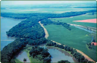
| Human activity often fragments, isolates , and simplifies
river habitats. Habitat diversity in the Mississippi River (left),
its backwaters (foreground), and its tributaries (top) exists
in contrast to the crop fields protected by levees (center). |
|
|