
|
PSR 2004-01 August 2004 Predicting Future Depth Conditions in
|
|
|
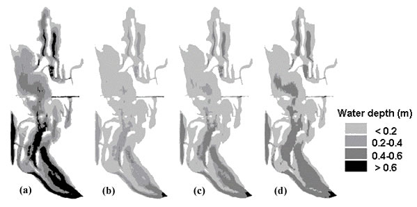
In a highly agricultural region like the Upper Mississippi River Basin, soils can be washed into rivers and streams at an alarming rate. This sediment ultimately makes its way into the Upper Mississippi River System (UMRS) and can settle in low-flow areas, such as backwater lakes. River managers have identified sediment accumulation (sedimentation) in backwaters as a major threat to the UMRS, primarily because of the potential for loss of critical shallow backwater habitats. To plan for changes in river habitat for fish, mussels, ducks, and other riverine biota, predictions of future conditions are needed. The Long Term Resource Monitoring Program scientists, from a recently completed 5-year study, estimated sedimentation rates in backwaters of Pools 4, 8, and 13 through the use of statistical models (project information available online at http://umesc.usgs.gov/data_library/ The most important predictors of sedimentation in the model were annual discharge and riverbed elevation. The effects of these predictors varied among the three study pools and also differed between aquatic and terrestrial areas. These four variables (discharge, bed elevation, study pool, and aquatic/terrestrial type) can be used to predict change in bed elevation at annual intervals. Running the model over multiple years produced forecasts of long-term changes in water depth. This approach was used in a geographic information system to predict and map future bathymetry in backwaters as a consequence of sedimentation. The computer program allows for varying discharge conditions based on past records, or exaggerated discharge conditions (e.g., discharge at a selected percentage greater than past records). As an example of how the model could be used, the 74-year historical period of discharge records was split into two 37-year past and present discharge periods. The figure illustrates a bathymetric condition at the present time and three different modeled future conditions (37 years from now; about 2040) based on three different discharge conditions. Discharge effects on sedimentation are observed as differences between the three forecasted conditions. The lower discharge patterns from 1927 to 1963 result in the most sedimentation (shallower water depths), whereas more recent higher discharge patterns for 1965 to 2001 result in less sedimentation. Using an exaggerated high discharge pattern (a 25% increase over the 1965-2001 discharge rate) with a mean discharge similar to that of the 5-year survey period, the model predicts even lower sedimentation if discharge patterns observed during the study continue. As with all modeling approaches, the best-fit models do not explain all the variation that exists in reality. For example, alluvial fan formation (i.e., within river delta) may be a more important process of sedimentation over a longer period, but these effects are obscured (or reduced) by sedimentation patterns more prevalent within pools for a shorter period. Also when using these predictions, additional consideration must be given to the potential for changes in sedimentation patterns. For example, sedimentation patterns may change as backwaters become more connected with channels in future years, a pattern that appeared evident in recent years. In that example, the loss of low-velocity conditions in backwaters is as much a threat to backwater habitat quality as is the loss of water depth. Differences in sedimentation among backwaters are only addressed in our model as a function of differences in bed elevation. The model could be improved by adding other predictors, such as water velocity, that may explain more of the differences among backwaters. Even with added predictors, however, 5 years of data may not be enough to detect some temporal patterns. The high discharge event in 2001, for example, might not have resulted in the observed erosion of aquatic areas we measured if a high discharge event had occurred in the previous year. Under those conditions, most of the easily erodible sediments would have been scoured in the previous year, and the effect of the high water in the following year may be reduced. Only a longer data set through time would give us insight into the more subtle dynamics of discharge effects. Nonetheless, the present models provide a first step in explaining spatial and temporal variability necessary to reasonably predict future effects of sedimentation in backwaters of the Upper Mississippi River. Armed with this information, managers will be able to plan how to provide habitat for species that might be affected by these changes.
|
|
|
This report is a product of the Long Term Resource Monitoring Program for the Upper Mississippi River System. For further information, contact James Rogala Project Status Reports (PSRs) are preliminary documents whose purpose is to provide information on scientific activities. Because PSRs are only subject to internal peer review, they may not be cited. Use of trade names does not imply U.S. Government endorsement of commercial products. All Project Status Reports are accessible through the Upper Midwest
Environmental Sciences Center's website at http://umesc.usgs.gov/reports_publications/ |
Page Last Modified: April 17, 2018