
|
PSR 2000-02 May 2000 Ecohydrology and Development of Ecological Criteria for Operation of Damsby Todd M. Koel1 |
|
|
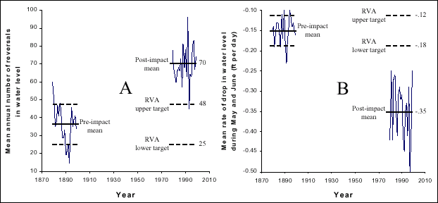
The Peoria and La Grange dams on the Illinois River, which define the La Grange Reach, each consist of a series of wickets that are raised during low-flow periods to increase water depth and tainter gates that are used to more precisely regulate water levels throughout the year. These dams have substantial effects on river hydrology, especially during low water periods of late summer and fall. Modern dam operation causes more frequent water-level fluctuations than there were under more natural conditions of the late 1800’s. The fluctuations caused by these management practices have affected biotic communities both in the river mainstem and in the backwater and unleveed floodplain areas. To identify conditions for sustaining native riverine flora and fauna while maintaining water levels for commercial navigation, I developed target criteria for operations of the Illinois River dams based on Indicators of Hydrologic Alteration (IHA) (The Nature Conservancy; http://www.freshwaters.org/ccwp/iha.html). Hydrological parameters were derived from a 21-year, pre-diversion (1879-1899) and post-diversion (1979- 1999) water level record for a historic gage site located at Copperas Creek (river mile 136.8, La Grange Reach). The pre-diversion data characterized the natural range of variation in 33 IHA parameters during this period. Parameters were calculated based on the entire calendar year and also for seasonal periods considered critical for plant and animal communities along the La Grange Reach floodplain corridor. Seasons were defined as spring (May and June), summer (mid-July through August), and winter (December and January). The range of variability (RVA) method was used to define targets for hydrologic variables on the Illinois River. Upper and lower target values for each parameter were + 1 standard deviation from the historic mean. Comparison of pre-diversion and post-diversion IHA parameters developed for the La Grange Reach indicated a high degree of hydrological alteration over the past 100 years. Of the 33 parameters developed for the entire year, only five post-diversion means were within established upper and lower target values. These parameters included the average stage in October and November, 90-day minimum stage, date of minimum stage, and major flood duration. The highest degree of hydrological alteration was for short-term minimum stage levels (1-day, 3-day, and 7-day), major recession count (waters below 25 th percentile of long term record), rise rate (increase in water level), fall rate (decrease in water level), and number of hydrograph reversals (change in direction of hydrograph). Changes in the annual number of hydrographic reversals, determined from previous analyses to be important for fish communities, are shown in Figure 1A. To enhance productivity of several native Illinois River fishes, the average number of hydrograph reversals experienced annually on La Grange Reach should be reduced from 70 per year to between 25 and 48 per year (Figure 1A). |
|
|
|
|
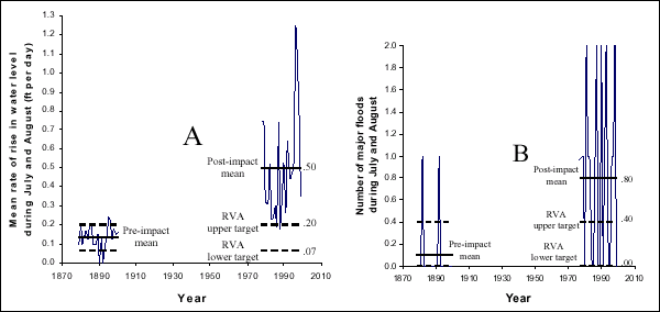
Range of variation targets defined for specific time periods of the year also indicated a high degree of hydrologic alteration. Of the 19 parameters derived for each specific season, only 10 post-diversion means for spring were within the RVA target range, as were 7 means for summer, and 5 means for winter. Rate of decline of water levels during May and June has increased dramatically over the past century, from an average of -0.15 feet per day to -0.35 feet per day (Figure 1B). This change in rate of water recession is probably detrimental for many aquatic species that are dependent on access to seasonally inundated, contiguous floodplains. Rate of rise of water surface elevations during July and August, and number of major floods during July and August, have also increased. Rates of rise have increased from an average of 0.13 feet per day to 0.50 feet per day (Figure 2A). Major floods in summer were rare in the late 1800s, whereas major floods are now common in July and August on the La Grange Reach (Figure 2B). This is significant because moist soil and submersed aquatic plant communities are highly dependent on low, stable water levels during mid-summer. |
|
|
|
|
Altered magnitude, timing, frequency, and duration of water levels disturb both terrestrial and aquatic communities of our large rivers. There-fore, the management of flows and resulting water levels should be a key component of river naturalization (restoring natural processes in a man-altered environment). Ecohydrology, here defined as the hydrology of rivers with respect to all the physical, chemical, and biological aspects of the system, should be used for management of our large rivers at an ecosystem scale. The benefits of naturally functioning floodplain ecosystems are known largely from the relatively pristine, tropical rivers. Naturalization of impaired systems could result in significant economic benefits due to increased biotic productivity, as well as benefits associated with higher biodiversity. |
|
|
1Minnesota Department of Natural Resources, Lake City, Minnesota |
|
|
This report is a product of the Long Term Resource Monitoring Program for the Upper Mississippi River System. For further information, contact U.S. Geological Survey Project Status Reports (PSRs) are preliminary documents whose purpose is to provide information on scientific activities. Because PSRs are only subject to internal peer review, they may not be cited. Use of trade names does not imply U.S. Government endorsement of commercial products. All Project Status Reports are accessible through the Upper Midwest Environmental Sciences Center’s website at http://umesc.usgs.gov/reports_publications/psrs/umesc_psr.html |
Page Last Modified: April 17, 2018