
|
PSR 2000-01 April 2000 Distribution of wild rice (Zizania aquatica l.) before and after the flood of 1993 in Pool 8 of the Upper Mississippi Riverby Terry Dukerschein and Heidi Langrehr |
||
|
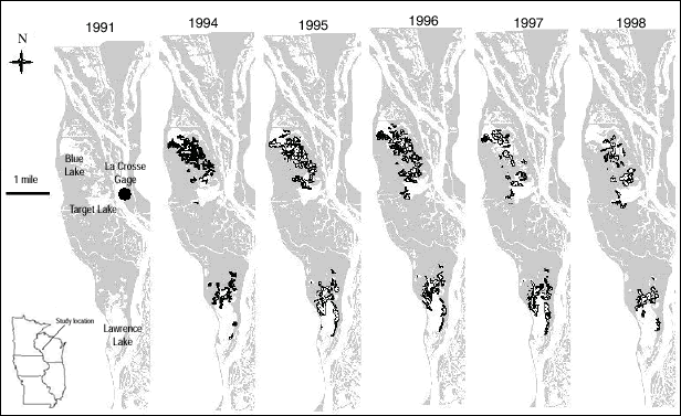
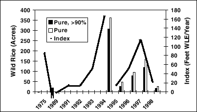
Wild rice (Zizania aquatica L.), a valuable food for humans and wildlife, was harvested by the Oneota culture in the La Crosse, Wisconsin area as early as 1300 A. D. It was abundant in sloughs along the Mississippi River in the La Crosse area in the 1800’s. Low-head navigation dams constructed by the U.S. Army Corps of Engineers in the mid-1930’s raised water levels in the area and changed the distribution of wild rice. A federal warden allegedly planted 40 acres of wild rice in Blue Lake, an isolated backwater in Pool 8, in the 1940’s. Wild rice provides excellent brood cover for many species of water birds, including the federally listed black tern, and provides food for waterfowl during the fall migration. Harvest is allowed by permit in Wisconsin and Minnesota, but not on the Upper Mississippi Fish and Wildlife Refuge. In 1989 and 1991-1998, 1:15,000 color infrared aerial photos of Navigation Pool 8 were taken by Long Term Resource Monitoring Program staff. After interpreting the field-checked photos, we used a Geographical Information System to map and quantify the distribution of wild rice in Pool 8 through time (Figure 1). Pure stands of wild rice were defined as those not visibly mixed with other species on the photo. We calculated an annual index of flooding to examine a potential relation between the acreage and distribution of pure wild rice stands in any given growing season and the magnitude and timing of floods in the year before its most vulnerable growth stage (floating leaf stage). The index was based on the total feet of surface water level elevation per year that exceeded our pre-defined threshold of 635.3 feet. This threshold was calculated from 20 years of historical water level elevation data collected at the La Crosse Gage by the U. S. Army Corps of Engineers (Figure 1). The shallow root system of wild rice does not tolerate changes in water level elevation exceeding 0.5 feet per day during and after the floating-leaf stage of development. Thus, we defined our preseason growth year to include the period from June 15 of the previous year to June 14 of the present year’s growing season. Flooding before mid-June would presumably be helpful, whereas flooding from June 15 to early July would uproot wild rice. |
||
|
||
|
Coverages of wild rice increased substantially in Pool 8 after the flood of 1993 (Figures 1, 2). In 1994, wild rice was observed in the field and delineated on photos in Lawrence Lake, a backwater where it had not been previously observed by Long Term Resource Monitoring Program staff, but where it had been observed and delineated on photos taken in 1975 by the U. S. Fish and Wildlife Service (Figures 1, 2). Wild rice was mainly delineated in three mid-pool backwaters of Pool 8 (Blue Lake, Target Lake, Lawrence Lake). Pure stands of wild rice were most abundant (361 acres) in Blue Lake in 1994. By 1998, pure and mixed stands of wild rice had declined in Blue Lake, and pure stands had declined in all backwaters studied. Field observations in 1999 showed an increase in Lawrence Lake. The 100-year flood in the summer of 1993 was unusual both in timing (occurring in summer rather than in spring) and in duration (lasting more than 6 weeks). Field observations showed that the flooding of 1993 uprooted or disturbed the growth of many species of aquatic plants. In 1994, water level elevations rose above the defined flood threshold in late April, gradually dropping to typical summer levels by June 6, and remaining low and stable through the floating leaf stage of growth. The large disturbance the summer before and the stable water levels during the 1994 growing season probably created favorable growth conditions for this opportunistic annual plant species, which can survive in dormant seed banks for 5 years or more. |
||
|
||
|
The increase in wild rice cover in 1994 was large enough that spatial auto-correlation due to seed-drop or other factors could account for the wild rice cover in subsequent years. However, the flood index graphed with acres of pure wild rice delineated demonstrates a potential relation between acres of wild rice delineated and flooding duration/ magnitude in the prior year (Figure 2). Wild rice was delineated following the 1993 flood at index levels of as low as 20 feet per year. It was not delineated at those index levels or even at twice those levels in the years just preceding the flood of 1993 (Figure 2). This suggests that the flood of 1993 might have played a role in resetting succession for wild rice in these backwaters; however, many potential variables and mechanisms could be involved. Possible flood related mechanisms could include removal of competing perennial plants, flushing of nutrient-rich sediments, cleansing of accumulated debris and metabolic toxins, and increased scratching of wild rice seed-coats which in turn could have enhanced germination the following year. |
||
|
This report is a product of the Long Term Resource Monitoring Program for the Upper Mississippi River System. For further information, contact J. Therese
Dukerschein U.S. Geological Survey Project Status Reports (PSRs) are preliminary documents whose purpose is to provide information on scientific activities. Because PSRs are only subject to internal peer review, they may not be cited. Use of trade names does not imply U.S. Government endorsement of commercial products. All Project Status Reports are accessible through the Upper Midwest Environmental Sciences Center’s website at http://umesc.usgs.gov/reports_publications/psrs/umesc_psr.html |
Page Last Modified: April 17, 2018