
|
PSR 98-12 December 1998 Agricultural Non-point Pollutant Loading Patterns in Upper Mississippi River Watershedsby Prasanna H. Gowda |
|
The transformation of basin landscape structure resulting from land cover/land use changes, with subsequent alteration in stream regimes and patterns of nonpoint source pollution, represents a widespread threat to the health of ecosystems. The United States Environmental Protection Agency (USEPA) reported that non-point source pollution from agricultural fields in upland areas accounted for 60% of surface water contamination in 1990, with sediments, nutrients and pesticides being the major pollutants. By 1994, discharges from agricultural lands affected 72% of impaired river areas, 57% of impaired lake areas, and 43% of impaired estuarine areas assessed in the United States. In response to the growing degradation of water quality, the USEPA, United States Department of Agriculture (USDA), and several state governments adopted the “Watershed Protection Approach” (WPA) to water quality management, sharing a common consensus that water quality problems can best be addressed at the watershed level. The WPA provides a framework to encourage managers to examine all the factors contributing to water quality problems in a watershed and then apply a comprehensive approach to resolving those problems. Floodplains of the Upper Mississippi River System (UMRS) annually receive high loads of sediment and agri-chemicals such as nitrate, phosphorus and pesticides from their watersheds. Some studies suggest that nutrient enriched water from the Mississippi River is the main cause of a hypoxic zone in the Gulf of Mexico. In 1995, other researchers estimated that the Upper Mississippi River Basin (UMRB) accounts for about 31% of the nitrogen delivered to the Gulf of Mexico. Detailed scientific inquiry is necessary for understanding the magnitude and spatial patterns of sediment and agri-chemical loadings from the agricultural areas of the Upper Mississippi River watersheds. Results of this study will be incorporated into a Decision Support System (DSS) for use in developing alternative management scenarios for reducing nonpoint pollutant loadings to the UMRS. |
|
The objectives of this study are to develop a soil erosion map
using the Universal Soil Loss Equation (USLE), determine and evaluate
sediment delivery ratios for all of the watersheds (USGS 1:250,000
hydrologic units), and evaluate statistical relationships between
land cover distribution and water quality. This information will
then be used to rank the watersheds based on sediment loadings from
their agricultural sources to the UMRS.Statistical models developed
in this study are expected to assist the Natural
Resources Conservation Service (NRCS) and the USEPA to |
|
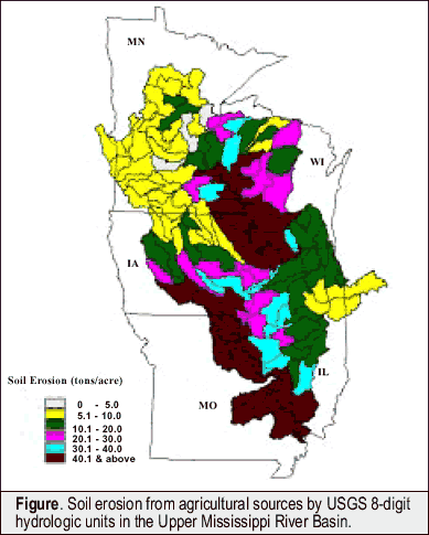
To develop a soil erosion map of the UMRB, a unique hydrologic response unit map was developed by overlaying soil (slope and soil erodibility factor), landcover, and rainfall erosion index maps. Rainfall/runoff factor (R), generally equal to local values of the rainfall erosion index, was derived from the isoerodent map. The slope length and steepness factor (LS) values for each of the unique hydrologic response units were derived from the LS-factor table provided in the Agriculture Handbook (USDA, 1978). An annual soil erosion rate for each of the unique hydrologic units was calculated using the USLE (Wischmeier and Smith, 1978): A = R•K•LS•C•P where: A is the computed soil erosion rate, R is the rainfall/runoff factor, K is the soil erodibility factor, LS is the slope length and steepness factor, C is the cover and management factor, and P is the control practice factor. Finally, soil erosion rates were determined for each of the hydrologic units. The figure illustrates the annual average soil erosion rates for agricultural areas in each of the hydrologic units in the UMRB. The USLE provides estimates of average annual soil loss from sheet and rill erosion. In order to account for soil erosion due to the remaining erosion processes found in streams, woodlands, etc., a sediment delivery ratio for each of the hydrologic units will be determined and used for ranking the watersheds. A set of statistical regression models is being developed for determining sediment delivery ratio as a function of landcover distribution. The statistical regression models developed in this study will be incorporated into the DSS now being developed at the Upper Midwest Environmental Sciences Center. |
|
This report is a product of the Long Term Resource Monitoring Program for the Upper Mississippi River System. For further information, contact Dr. Prasanna H. Gowda U.S. Geological Survey Project Status Reports (PSRs) are preliminary documents whose purpose is to provide information on scientific activities. Because PSRs are only subject to internal peer review, they may not be cited. Use of trade names does not imply U.S. Government endorsement of commercial products. All Project Status Reports are accessible through the Upper Midwest Environmental Sciences Center’s website at http://umesc.usgs.gov/reports_publications/psrs/umesc_psr.html |
 better
implement federally funded environmental protection programs such
as Conservation Reserve Programs and Environmental Quality Incentive
Programs.
better
implement federally funded environmental protection programs such
as Conservation Reserve Programs and Environmental Quality Incentive
Programs.Page Last Modified: April 17, 2018