
|
PSR 98-10 October 1998 Assessment of Aerial Photointerpretation for Detecting Submersed Aquatic Vegetationby Heidi A. Langrehr and J. Therese Dukerschein |
||||||||||||||||||||||||||||||||||||||||||||||||||||||
|
Submersed aquatic (underwater) vegetation is an important habitat component of the Upper Mississippi River System (UMRS). It provides cover, food, and spawning habitat for fish and invertebrates as well as food for waterfowl. Submersed aquatic vegetation also affects its immediate environment by acting as a nutrient source or sink, slowing velocity to allow suspended material to settle, and altering temperature, light penetration and dissolved substances in the surrounding water. In recent years, resource managers have perceived a decline in submersed aquatic vegetation in the UMRS. Long term trend data, collected over a broad spatial scale, is needed to substantiate or refute these perceptions. |
||||||||||||||||||||||||||||||||||||||||||||||||||||||
|
As part of the Long
Term Resource Monitoring Program (LTRMP), vegetation is monitored
from 1:15,000 color infrared aerial photographs in six standard
LTRMP study pools. Included are Pools 4, 8, 13, 26 and the Open
River Reach of the Upper Mississippi River and La Grange Pool of
the Illinois River. |
||||||||||||||||||||||||||||||||||||||||||||||||||||||
|
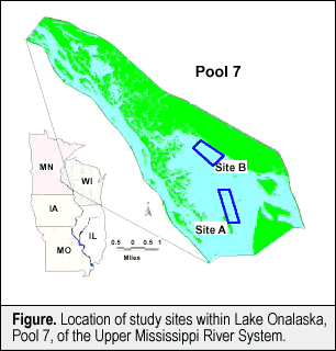
Color infrared aerial photographs at a scale of 1:15,000 were taken of study sites A and B on July 21, 23, and 24 (two sets), September 1 (two sets), and September 5, 1995. Water quality data was collected following standard LTRMP procedures at twenty randomly chosen sampling points (10 per site) each day aerial photographs were taken, except for July 23, 1995. Parameters measured included turbidity, secchi depth, wave height, and an estimate of percent cloud cover. Average turbidities ranged from 8 NTU to 18 NTU with the highest average turbidity recorded on July 21 at Site B (18 NTU). During the study period, water surface elevations in Pool 7 did not fluctuate more than 3 inches (7.6 cm) per day, with a maximum fluctuation of 2 feet (60.9 cm) over a period of eight days. Wind speed and direction were obtained from the La Crosse Airport, located on the southern bank of Lake Onalaska. Wind speed ranged from 5 mph to 10 mph. |
||||||||||||||||||||||||||||||||||||||||||||||||||||||
|
||||||||||||||||||||||||||||||||||||||||||||||||||||||
|
Submersed aquatic vegetation was sampled at 199 points from August 28 to August 30, 1995. Site A had 51 sampling points with submersed vegetation out of 98 total while Site B contained 24 vegetated sites (101 total). Map accuracy, defined as percent of correctly labeled polygons in the coverage, ranged from 53% to 78% and combined aerial photointerpretation correctly identified open water (91%) more often than it correctly identified submersed vegetation (29%). The percentage of sampling points (Table) correctly identified as open water (no vegetation was present on the rake and the coverage assigned an open water classification to the point) ranged from 100% (Site B, July 21) to 76% (Site A, July 23). Site B had a higher combined percentage of correctly identified open water sampling points (99%) than Site A (78%). The percentage of sampling points correctly identified as containing submersed vegetation (submersed vegetation was present on the rake and the coverage assigned a submersed vegetation classification to the point) was much lower than the open water percentage. Site A had the highest correct percentage (45%; July 21) while Site B had the lowest (0%; September 1). Analyzing only for points where submersed vegetation was at the surface increased the percentages, however the highest percentage correct was slightly over half (July 23, Site 1). Water stargrass (Heteranthera dubia [Jacq.] MacM) was the species best detected by aerial photointerpretation (44%) while wild celery (Vallisneria americana Michx.) and Eurasian watermilfoil (Myriophyllum spicatum L.) were detected slightly less often (39%). Although overall map accuracy was fairly high, the accuracy was due mostly to open water being correctly classified. The ability of the aerial photointerpreter to detect submersed vegetation did not appear to be related to water quality parameters, probably because the measured parameters were not very different between sites and days. Aerial photointerpretation of Site B did not detect submersed vegetation as well as interpretation of Site A; however, fewer plants were present at Site B. Aerial photointerpretation consistently underestimated the presence of submersed vegetation in this study. |
||||||||||||||||||||||||||||||||||||||||||||||||||||||
|
This report is a product of the Long Term Resource Monitoring Program for the Upper Mississippi River System. For further information, contact Heidi A. Langrehr J. Therese
Dukerschein U.S. Geological Survey Project Status Reports (PSRs) are preliminary documents whose purpose is to provide information on scientific activities. Because PSRs are only subject to internal peer review, they may not be cited. Use of trade names does not imply U.S. Government endorsement of commercial products. All Project Status Reports are accessible through the Upper Midwest Environmental Sciences Center’s website at http://umesc.usgs.gov/reports_publications/psrs/umesc_psr.html |
||||||||||||||||||||||||||||||||||||||||||||||||||||||
 Because
it is difficult to physically collect quantitative vegetation information
in a system as vast as the UMRS, photointerpretation was proposed
as a means of estimating submersed plant coverages for detecting
trends across the system more comprehensively than current resources
allow. Our study assesses how accurately photointerpretation of
LTRMP color infrared aerial photography detects aquatic vegetation
occurring below the water surface of the Upper Mississippi River.
Previous studies indicate that the ability to detect submersed vegetation
is linked to water clarity and depth.
Because
it is difficult to physically collect quantitative vegetation information
in a system as vast as the UMRS, photointerpretation was proposed
as a means of estimating submersed plant coverages for detecting
trends across the system more comprehensively than current resources
allow. Our study assesses how accurately photointerpretation of
LTRMP color infrared aerial photography detects aquatic vegetation
occurring below the water surface of the Upper Mississippi River.
Previous studies indicate that the ability to detect submersed vegetation
is linked to water clarity and depth.Page Last Modified: April 17, 2018