|
In 1997, staff at the Environmental Management Technical Center
(EMTC), in cooperation with the U.S. Fish and Wildlife Service,
 photographed
the Mississippi and Illinois Rivers and their floodplains from the
air. Approximately 2,000 oblique photographs, in slide format, were
acquired for ongoing research to evaluate changes in floodplain
structure along the navigable length of the Mississippi River (Minneapolis,
Minnesota to the Gulf of Mexico). Nearly 300 photographs were obtained
along the Illinois River between Chillicothe, Illinois and the mouth
of the River at Grafton, Illinois. These photographs capture aspects
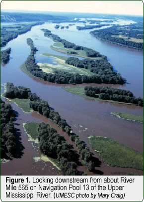
of the rivers’ landscapes (Figure 1) as well as document river-management
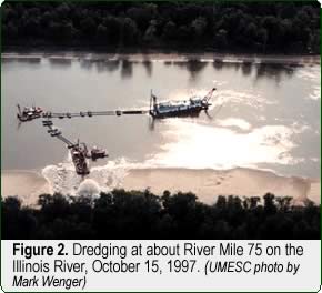
activities such as channel maintenance practices (Figure 2) and
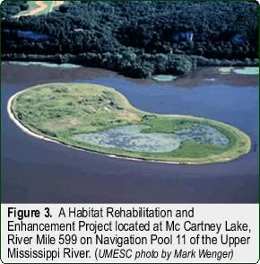
habitat rehabilitation and enhancement projects (Figure 3). photographed
the Mississippi and Illinois Rivers and their floodplains from the
air. Approximately 2,000 oblique photographs, in slide format, were
acquired for ongoing research to evaluate changes in floodplain
structure along the navigable length of the Mississippi River (Minneapolis,
Minnesota to the Gulf of Mexico). Nearly 300 photographs were obtained
along the Illinois River between Chillicothe, Illinois and the mouth
of the River at Grafton, Illinois. These photographs capture aspects
of the rivers’ landscapes (Figure 1) as well as document river-management
activities such as channel maintenance practices (Figure 2) and
habitat rehabilitation and enhancement projects (Figure 3).
River managers and scientists have expressed great interest in this
collection of oblique aerial photographs. To date, we have received
requests for more than 600 duplicate slides from a variety of sources
including federal and state agencies, universities, and a private,
natural resource group seeking to establish a sanctuary. Staff at
the EMTC are in the process of making this valuable collection of
photographs of the Mississippi and Illinois Rivers easily accessible
to a wide audience.
|
|
 We
have received financial assistance from the National Biological
Information Infrastructure initiative of the U.S. Geological Survey’s
Biological Resources Division
to make the photographs broadly available to interested parties
through the World Wide Web. To provide on-line access to these photographs,
we are preparing to serve high-resolution images of them from our
web site (http://umesc.usgs.gov).
Slides are being electronically scanned and their locations are
being geo-referenced. Our web page will be updated and modified
in order to serve these oblique aerial photographs along with the
color-infrared aerial photographs we now serve. The first oblique
aerial photographs to be served will be of the Upper Mississippi
River reach that extends from Cairo, Illinois to St. Louis, Missouri.
They should be available on our web site by February 1999, and the
entire collection of 2,300 oblique aerial photographs should be
electronically accessible by November 1999. We
have received financial assistance from the National Biological
Information Infrastructure initiative of the U.S. Geological Survey’s
Biological Resources Division
to make the photographs broadly available to interested parties
through the World Wide Web. To provide on-line access to these photographs,
we are preparing to serve high-resolution images of them from our
web site (http://umesc.usgs.gov).
Slides are being electronically scanned and their locations are
being geo-referenced. Our web page will be updated and modified
in order to serve these oblique aerial photographs along with the
color-infrared aerial photographs we now serve. The first oblique
aerial photographs to be served will be of the Upper Mississippi
River reach that extends from Cairo, Illinois to St. Louis, Missouri.
They should be available on our web site by February 1999, and the
entire collection of 2,300 oblique aerial photographs should be
electronically accessible by November 1999.
|
|
 This
collection of aerial photographs of the Mississippi and Illinois
Rivers will serve as a rich and invaluable resource for river managers
and scientists for assessing habitat needs, planning habitat rehabilitation
and enhancement projects, developing decision support systems, executing
adaptive ecosystem assessments, and planning emergency responses
to potentially hazardous and toxic spills. These photographs will
be a great “river map” source for the public, and they
will continue to be used to further research and support ongoing
resource management and planning activities on the Mississippi and
Illinois Rivers. This
collection of aerial photographs of the Mississippi and Illinois
Rivers will serve as a rich and invaluable resource for river managers
and scientists for assessing habitat needs, planning habitat rehabilitation
and enhancement projects, developing decision support systems, executing
adaptive ecosystem assessments, and planning emergency responses
to potentially hazardous and toxic spills. These photographs will
be a great “river map” source for the public, and they
will continue to be used to further research and support ongoing
resource management and planning activities on the Mississippi and
Illinois Rivers.
|
|
This report is a product of the Long Term
Resource Monitoring Program for the Upper Mississippi River
System.
For further information, contact
U.S. Geological Survey
Upper Midwest Environmental Sciences Center
575 Lester Avenue
Onalaska, Wisconsin 54650
Phone: 608/783-7550
Fax: 608/783-8058
Project Status Reports (PSRs) are preliminary documents whose purpose
is to provide information on scientific activities. Because PSRs
are only subject to internal peer review, they may not be cited.
Use of trade names does not imply U.S. Government endorsement of
commercial products.
All Project Status Reports are accessible through the Upper Midwest
Environmental Sciences Center’s website at http://umesc.usgs.gov/reports_publications/psrs/umesc_psr.html
|
