|
April 1998 PSR 98-05 Recent Sedimentation Rates in the Finger Lakes Complex of the Upper Mississippi River Systemby Pete J. Boma and James T. Rogala |
||
|
Sedimentation in backwaters of the Upper Mississippi River System
(UMRS) has been a concern of resource managers since impoundment
of the river in the late 1930's. This concern has centered around
the reduction of habitat diversity. To assess the problem of habitat
loss, estimates of sedimentation rates are needed. In particular,
current rates of sedimentation are needed to better predict future
conditions. In addition, the annual variability in sedimentation
rates may provide valuable information on trends and suggest processes
which determine these rates. Although large changes in sedimentation
rates occurring over longer time periods have been measured as differences
in bathymetric maps from different time periods or by using markers
in the sediments, these methods cannot estimate annual or very recent
sedimentation rates. |
||
|
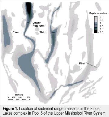
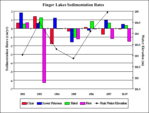
Transects were selected near the center of each lake where a stable bank was located and vertical benchmarks were established. Fenceposts were driven into the shore to relocate each transect in subsequent years. Three nails were placed in separate trees as benchmarks so differences in water surface elevation during surveys could be determined yearly. Each survey year, a measuring tape is placed over the ice along the transect by aligning the tape with the fenceposts. Holes are drilled every 7.62 meters across the entire backwater and water depths are measured with a sounding pole. The elevation of the sediment relative to the benchmarks is calculated using the water elevation and water depth measurements for each survey. Sedimentation rates were calculated as changes in sediment elevation for each site along the transects for all time periods. Mean rates were also calculated for the entire transect for each time period (Figure 2).Transects in Third and Lower Peterson Lakes were the deeper transects with average water depths of 0.87 and 1.00 m during the winter surveys. Transects in these two lakes had accumulation of sediment from 1992 to 1997 at rates of 0.35 and 0.49 cm /yr. In comparison, transects in Clear and First Lakes were somewhat shallower with average water depths of 0.6 and 0.38 m and were found to be erosional from 1992 to 1997 with rates of -0.06 and -1.51 cm/yr. Sedimentation was variable among transects in most years, with net accumulation along all transects in 1992 and net erosion along all transects in 1995. |
||
|
||
|
The First Lake transect was found to have the greatest amount of erosion (6.27 cm) for a single year, that occurring in 1993. Two factors likely contributing to these high rates of erosion are the close proximity of the transect to the main channel of the river and a prominent flood in 1993. The other three transects were accumulating sediment during 1993, with Clear, Third and Lower Peterson Lake transects having rates of 1.40, 1.24, and 0.61 cm/yr, respectively. This may be attributed to the more isolated nature of these three lakes, thereby providing a low velocity environment conducive to precipitation of suspended sediments from the 1993 flood waters. Another prominent flood in 1997 resulted in a similar pattern, but lower erosional rates were found along the First Lake transect and the Clear Lake transect was also erosional in that year. A similar response in sedimentation rates to floods has been reported for other LTRMP transects. Although culverts installed during the habitat project changed the flow regime to three of the four lakes, we could not document any changes that altered flows may have had on the sedimentation rates of the transects in the Finger Lakes complex. The estimates of sedimentation rates we obtained do not represent rates occurring in each lake or in the complex as a whole, but do provide estimates of sedimentation rates occurring along each transect. Along these transects, we observed that sediments in a backwater subject to flow during periods of high water can be eroded and that deeper backwaters may be more apt to accumulate sediments if a high water event does not occur. It should be noted that sedimentation patterns observed over a relatively short time period ( 7 years ) may not acurately represent patterns over longer time periods. Therefore, the LTRMP plans to continue the annual monitoring of the Finger Lakes sediment range transects to provide estimates of sedimentation rates over longer time periods, as well as provide valuable information on variability in the rates of sedimentation. |
||
|
This report is a product of the Long Term Resource Monitoring Program for the Upper Mississippi River System. For further information, contact Pete J. Boma James T. Rogala Project Status Reports (PSRs) are preliminary documents whose purpose is to provide information on scientific activities. Because PSRs are only subject to internal peer review, they may not be cited. Use of trade names does not imply U.S. Government endorsement of commercial products. All Project Status Reports are accessible through the Upper Midwest Environmental Sciences Center’s website at http://umesc.usgs.gov/reports_publications/psrs/umesc_psr.html |
Page Last Modified: April 17, 2018


 The
The
