
|
April 1998 PSR 98-04 An Empirical Fingernail Clam Model for Upper Mississippi River Pools 7 and 8by Randy W. Burkhardt and Shawn E. Weick |
|
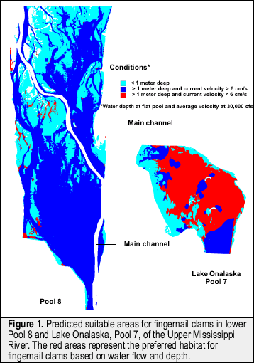
Fingernail clams (Sphaeriidae) are important food sources for fish and migrating waterfowl in the Upper Mississippi River (UMR). Historically, fingernail clam densities ranged from 1,000 - 10,000 m-2 (per square meter) in parts of the UMR. Recent studies indicate that fingernail clam populations may be on the decline. In 1975, lower Pool 8 had fingernail clam densities as high as 2,400 m-2. More recent sampling (yearly since 1992) conducted by personnel from the Long Term Resource Monitoring Program, the U.S. Fish and Wildlife Service, and the Wisconsin Department of Natural Resources have shown fingernail clam densities averaging < 20 m-2 in lower Pool 8 of the UMR. To try to understand the fingernail clam population distribution, a study was initiated during 1995 in Lake Onalaska of UMR Pool 7 and expanded to lower Pool 8 in 1996. The main focus of this study was to create and test an empirical model that would identify suitable areas for fingernail clams based on modeled water flow and bathymetry (water depth). The St. Paul District of the U. S. Army Corps of Engineers provided flow data from a hydraulic model called FastTABS and the Environmental Management Technical Center provided bathymetry information. |
|
Field samples consisted of 48 standard ponar samples per pool,
randomly selected within 6 regions (8 sites/region) and classified
by modeled flow and bathymetry. |
|
These results suggest that fingernail clam declines in lower Pool
8 may be linked to habitat loss. Some massive habitat changes have
occurred in |
|
This report is a product of the Long Term Resource Monitoring Program for the Upper Mississippi River System. For further information, contact Randy W. Burkhardt Project Status Reports (PSRs) are preliminary documents whose purpose is to provide information on scientific activities. Because PSRs are only subject to internal peer review, they may not be cited. Use of trade names does not imply U.S. Government endorsement of commercial products. All Project Status Reports are accessible through the Upper Midwest Environmental Sciences Center’s website at http://umesc.usgs.gov/reports_publications/psrs/umesc_psr.html |
 Sites
were sampled in July and August of 1995 and during July and September
of 1996. All samples were preserved and the fingernail clams were
later identified and enumerated in the lab.
Sites
were sampled in July and August of 1995 and during July and September
of 1996. All samples were preserved and the fingernail clams were
later identified and enumerated in the lab.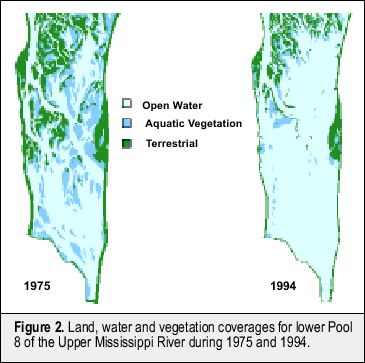 lower
Pool 8 since 1975 (Figure 2), when fingernail clam densities were
found as high as 2,400 m-2. Vast vegetation beds and small islands
present in 1975 have all but disappeared. With these losses, the
hydrodynamics of lower Pool 8 have changed. Many low flow areas
associated with vegetation beds and islands have been lost.
lower
Pool 8 since 1975 (Figure 2), when fingernail clam densities were
found as high as 2,400 m-2. Vast vegetation beds and small islands
present in 1975 have all but disappeared. With these losses, the
hydrodynamics of lower Pool 8 have changed. Many low flow areas
associated with vegetation beds and islands have been lost.Page Last Modified: April 17, 2018