
|
PSR 98-03 February 1998 Presettlement Vegetation Patterns along Navigation Pool 17 of the Upper Mississippi Riverby John C. Nelson,1 Kenneth S. Lubinski, and Melvin L. Bower |
||
|
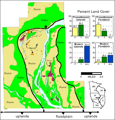
The Upper Mississippi River flows south through an eastern extension of the great plains known as the prairie peninsula. For decades, ecologists have characterized the uplands of the prairie peninsula as a landscape once dominated by grasslands, savannas, and open woodlands with forests restricted mainly to the large river valleys. The Long Term Resource Monitoring Program (LTRMP) recent findings, from several Navigation Pools including Pool 17, challenge the long held perception that forests were the dominant community type along the Mississippi River valley before European-American settlement. A presettlement (1817-1837) reconstruction of the Mississippi River valley, along Navigation Pool 17 using General Land Office (GLO) survey data, reveals that prairies were once the dominant community type on the floodplain (see figure below). Forests were generally restricted to the islands, the banks of the Mississippi River and its tributaries, and to the valley slopes and ravines. Presettlement tree density estimates of these forests indicate dense stands prevailed on the islands (88 trees/ha), while more open woodland and savanna communities prevailed on the floodplain (17 trees/ha) and surrounding uplands (6 trees/ha). The maintenance of upland prairies, savannas, and woodlands has long been attributed to annual fires set by Native Americans in the centuries before the arrival of Europeans. In contrast, hydrology has long been considered the principal factor influencing plant community types and distributions on large river-floodplains. The possibility that fire was a disturbance mechanism on the floodplains of the Mississippi River has received little attention. However, it is likely that fire did play an important role in maintaining some floodplain prairies, savannas, and open woodlands. Since many Native American cultures flourished within the Mississippi River valley, there is no reason to believe they would restrict their burning practices only to surrounding upland landscapes. Furthermore, trees can grow almost anywhere on the floodplains of the Mississippi River, except in isolated places where water stands throughout much of the growing season. Thus, frequent fire disturbance could explain why prairies were so extensive on the higher elevations of the floodplain, while trees were restricted to the margins of water courses and islands. |
||
|
||
|
The effects of a fire were noted by a GLO surveyor while he and his crew crossed the floodplain along the Illinois side of Pool 17: "The timber on the south end is much destroyed by fire - a heavy body of good timber lies about 25 chains [1650 ft.] west". On the Iowa side, another GLO surveyor made reference to the previous inhabitants of the river valley; "This township has been the home of thousands of Indians, and not many years since. The whole range of bottom land immediately under the bluff has been covered with Indian diggings as we call them, corn hills yet visible where they have cultivated many years ago. Indeed I think it not surprising that either Whites or Indians should make this great cove, a place of residence. The soil is in general, of the first quality of prairie, and timber very convenient on the hillsides and valleys...". Thus, we have compelling evidence that fires once burned across some floodplains. Our predecessors likely used fire to prepare land for agricultural purposes and to maintain prairies, savannas, and open woodlands across both upland and floodplain landscapes. Today, the Pool 17 landscape is nearly devoid of its former prairies. Some small prairies can be found on the floodplain, but the current limited status of this community and its associated savannas and woodlands should be a primary concern for natural resource managers. It is encouraging to find the quantity of timberlands on the floodplain today is similar to the quantity existing over 160 years ago. This trend is not common throughout the entire river system nor to most upland regions of the Midwest. It is the direct result of land being protected within the Mark Twain National Fish and Wildlife Refuge of the Upper Mississippi River Valley. The trend further indicates the high potential that exists for restoration and ecosystem management. The current quality of these floodplain forests, however, need to be assessed due to their past exploitation for lumber and fuel wood, and due to the effects of navigation dams and extreme flooding. In the near future, the LTRMP will provide presettlement forest composition and community structure attributes to help refuge managers assess the quality of floodplain forests. |
||
|
1Illinois Natural History Survey, LTRMP Alton Field Station |
||
|
This report is a product of the Long Term Resource Monitoring Program for the Upper Mississippi River System. For further information, contact Dr. Kenneth S. Lubinski Melvin L. Bower Project Status Reports (PSRs) are preliminary documents whose purpose is to provide information on scientific activities. Because PSRs are only subject to internal peer review, they may not be cited. Use of trade names does not imply U.S. Government endorsement of commercial products. All Project Status Reports are accessible through the Upper Midwest Environmental Sciences Center’s website at http://umesc.usgs.gov/reports_publications/psrs/umesc_psr.html |
Page Last Modified: April 17, 2018