
|
PSR 98-01 January 1998 A GIS Model for Predicting Winter Habitat Suitability in Backwaters of the Upper Mississippi Riverby James T. Rogala and David M. Soballe |
||
|
Habitat suitability for overwintering fish in the Upper Mississippi River System (UMRS) is a major concern of resource managers and the focus of numerous studies. Previous investigations yielded valuable information on habitat needs by showing that water depth, dissolved oxygen, water temperature, and current velocity are all potential limiting factors for overwintering fish. These studies, conducted in laboratories or small areas, must be combined with a large-scale approach (e.g., entire navigational pools) to assess habitat needs and availability for fish populations across the whole system. Unfortunately, we cannot make repeated, detailed, and comprehensive surveys of habitat conditions at large spatial scales, so we must extrapolate from limited existing data to estimate the location or spatial extent of suitable habitat across broad areas. In this regard, two sets of Geographic Information System (GIS) data (coverages) generated by the Long Term Resource Monitoring Program (LTRMP) have proven extremely useful. Land-cover data, based on the interpretation of aerial photographs from nearly the entire UMRS, shows the land-water boundary and provides some information on aquatic vegetation. The second coverage classifies water areas into categories in a hierarchical structure based on general geomorphic features. Our efforts focused on all contiguous backwater classes except for impounded areas. Contiguous backwaters are believed to provide much of the suitable overwintering habitat for sunfishes (Centrarchidae) and have been targeted for restoration and enhancement by UMRS resource managers. Our extrapolation approach was to use simple morphometric measurements derived from the GIS to predict habitat suitability. Although detailed bathymetric data are available for some reaches of the UMRS and can be extremely useful in mapping overwintering habitat, these types of data are not available for the entire system and are excluded from this analysis. This exercise posed some conceptual and technical challenges. First, the delineation of individual backwaters in the GIS was difficult because these waterbodies are not fully enclosed by a shoreline. To circumvent this, we defined the perimeter of each backwater using the shoreline (land-water interface) where present and the border of any adjoining channel (as defined in the aquatic area coverage) where a shoreline was absent. Then, we classified the habitat suitability of each backwater in a way that was both meaningful to overwintering fish and applicable to an entire backwater. We knew from our field studies that conditions across a backwater can vary dramatically beneath the ice, that fish can be mobile during winter, and that they can find and use relatively small areas. We also knew that predicting the precise location of small habitat patches within an individual backwater was probably not feasible and was not the focus of our large-scale assessment. However, the presence or absence of suitable habitat patches, regardless of exact location, was critical to assessing the habitat value of a backwater. Consequently, in one phase of our field sampling we specifically searched for suitable habitat patches within randomly selected backwaters. In this particular modeling exercise we used the results of that search to link backwater suitability to morphometry. |
||
|
||
|
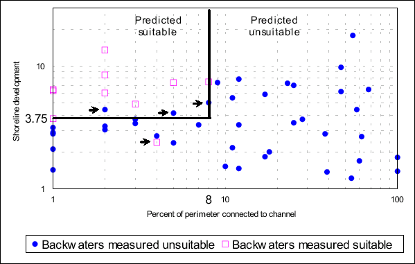
The first round of analyses focused on Pool 8. We used the GIS to calculate a host of basic morphometric characteristics (e.g., total perimeter, total surface area, shoreline develop ment, number of connections to channel, percent of perimeter represented by channel) for every backwater in Pool 8. We then used a sampling design that divided the backwaters into three sampling strata based on area and connectivity to channels, and randomly selected a total of 51 backwaters for field sampling. In February 1997, we intensively searched each randomly selected backwater for suitable overwintering conditions defined by water temperature greater than 0.5° C, current velocity less than 0.01 m/sec, dissolved oxygen greater than 2.0 mg/L, and water depth greater than 30 cm. Based on our field measurements, we then classified each water body in our sample as "suitable" if any location within the backwater was found that met our habitat criteria and "unsuitable" if no such site was found. Although conditions often varied dramatically within a single backwater, we were surprisingly successful in predicting backwaters where at least one suitable habitat patch could be found. Large backwaters were more likely to contain suitable habitat (60% were suitable) than smaller waterbodies with either a low connectivity (13% were suitable) or high connectivity (7% were suitable). We also found that suitable habitat patches were found in backwaters having a low percentage of the perimeter connected to channels and a high shoreline development ratio. Using only shoreline development and inconnected perimeterld we correctly classified 47 of the 51 sampled backwaters (Figure). We had similar success when we compared the habitat data collected in 1995 to these two morphometric measures. This is only a preliminary assessment based on data from Pool 8. We expect that some of our results may be specific to Pool 8 and its particular geomorphic configuration. Nonetheless, the results are encouraging for predicting habitat suitability on the basis of simple morphometric indices obtained from GIS coverages currently available for the whole system. If we have success in refining this approach and applying it to different reaches over differing years, it can be an extremely valuable tool for system-wide assessment of winter habitat suitability and habitat needs. |
||
|
This report is a product of the Long Term Resource Monitoring Program for the Upper Mississippi River System. For further information, contact James T. Rogala Dr. David M. Soballe Project Status Reports (PSRs) are preliminary documents whose purpose is to provide information on scientific activities. Because PSRs are only subject to internal peer review, they may not be cited. Use of trade names does not imply U.S. Government endorsement of commercial products. All Project Status Reports are accessible through the Upper Midwest Environmental Sciences Center’s website at http://umesc.usgs.gov/reports_publications/psrs/umesc_psr.html |
Page Last Modified: April 17, 2018