
|
PSR 97-13 December 1997 Watershed Data for the
|
||||||||||||||||||||||||||||||||||||||||||||||||||||||||||||||||||||||||||||||||||||||||||||||||||||||||||||||||||||||||||||||||||||||||||||||||||||||||||||||||||||||||||||||||||||||||||||||||||||||||||||||||||||||||||||||||||||||
|
The Upper Mississippi River System (UMRS) has been dramatically
altered by changing land use and management practices within its
basins. |
||||||||||||||||||||||||||||||||||||||||||||||||||||||||||||||||||||||||||||||||||||||||||||||||||||||||||||||||||||||||||||||||||||||||||||||||||||||||||||||||||||||||||||||||||||||||||||||||||||||||||||||||||||||||||||||||||||||
|
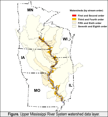
Description of Watershed Data The UMRS watershed (excluding the Missouri basin) encompasses an area of about 50 million hectares (121 million acres). It extends north from Cairo, Illinois, primarily through the states of Missouri, Illinois, Iowa, Wisconsin, and Minnesota. The 1:250,000-scale data layer for the basin contains watershed boundaries for basins larger than 150 acres that empty directly into the main stem floodplain of the UMRS. Watershed size, perimeter length, stream order, stream name (for basins larger than second order), and outlet location by navigation pool are included. U.S. Geological Survey 1:250,000-scale Digital Elevation Models (DEMs) were the primary sources used in developing the watershed data. Data Development Procedure The watershed data layer was developed through a procedure that utilized Arc/Info GIS hydrologic modeling tools. Arc/Info lattice files were generated from DEMs and converted to flow grid coverages. These were combined with basin outlet data to create a watershed grid. This grid was then converted to an Arc/Info polygon coverage and basin attribute information was added. Available Products Upper Mississippi River System watershed products are now available through the Upper Midwest Environmental Sciences Center in Onalaska, Wisconsin. These watershed products include a variety of digital, map, and analysis products. The GIS watershed data layer is available in an Arc/Info polygon coverage format. Several maps have been produced displaying basins for the entire UMRS, watersheds by pool, and basins overlaid on Digital Raster Graphics. Analysis products have also been generated that provide information on watershed characteristics for the UMRS basin (Table 1) and for the LTRMP trend analysis study areas (Table 2). |
||||||||||||||||||||||||||||||||||||||||||||||||||||||||||||||||||||||||||||||||||||||||||||||||||||||||||||||||||||||||||||||||||||||||||||||||||||||||||||||||||||||||||||||||||||||||||||||||||||||||||||||||||||||||||||||||||||||
*floodplain and near floodplain area |
||||||||||||||||||||||||||||||||||||||||||||||||||||||||||||||||||||||||||||||||||||||||||||||||||||||||||||||||||||||||||||||||||||||||||||||||||||||||||||||||||||||||||||||||||||||||||||||||||||||||||||||||||||||||||||||||||||||
|
||||||||||||||||||||||||||||||||||||||||||||||||||||||||||||||||||||||||||||||||||||||||||||||||||||||||||||||||||||||||||||||||||||||||||||||||||||||||||||||||||||||||||||||||||||||||||||||||||||||||||||||||||||||||||||||||||||||
|
The Future Future enhancements to the watershed data layer are currently being explored. These include adding attribute information (e.g., nearest downstream river mile), improving spatial accuracy of selected subbasins (e.g., 1:100,000 or 1:24,000-scale), and developing GIS subbasin data layers for the larger tributaries (e.g., Illinois and Minnesota Rivers) of the UMRS. |
||||||||||||||||||||||||||||||||||||||||||||||||||||||||||||||||||||||||||||||||||||||||||||||||||||||||||||||||||||||||||||||||||||||||||||||||||||||||||||||||||||||||||||||||||||||||||||||||||||||||||||||||||||||||||||||||||||||
|
This report is a product of the Long Term Resource Monitoring Program for the Upper Mississippi River System. For further information, contact Henry C. DeHaan Dr. Kenneth S. Lubinski Project Status Reports (PSRs) are preliminary documents whose purpose is to provide information on scientific activities. Because PSRs are only subject to internal peer review, they may not be cited. Use of trade names does not imply U.S. Government endorsement of commercial products. All Project Status Reports are accessible through the Upper Midwest Environmental Sciences Center’s website at http://umesc.usgs.gov/reports_publications/psrs/umesc_psr.html |
||||||||||||||||||||||||||||||||||||||||||||||||||||||||||||||||||||||||||||||||||||||||||||||||||||||||||||||||||||||||||||||||||||||||||||||||||||||||||||||||||||||||||||||||||||||||||||||||||||||||||||||||||||||||||||||||||||||
 One
consequence of these changes is the environmental problem of increased
sediment loading to its major rivers. The
One
consequence of these changes is the environmental problem of increased
sediment loading to its major rivers. The Page Last Modified: April 17, 2018