
|
PSR 97-12 November 1997 Reconstructing Lake Pepin’s Natural Historyby John C. Nelson,1 Richard E. Sparks,2 and Melvin L. Bower3 |
|
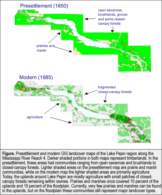
Using historical survey records of the U.S. General Land Office (GLO), we reconstructed the general structure and distributional patterns of plant communities that existed over 150 years ago in the region around Lake Pepin of the Upper Mississippi River. Computer-generated maps now identify the location and extent of former prairies, swamps, marshes, lakes, ponds, and timberlands (see figure). Analyses of GLO bearing tree records are providing clear pictures of the types of trees common to islands, floodplains, terraces, and uplands. Even the distances that surveyors measured to obtain bearing trees at section corners are generating valuable details about the former extent of savannas, woodlands, and closed-canopy forests.
Visualizing the landscape: In 1850, the Lake Pepin region had a diverse and complex assemblage of natural plant communities. General Land Office surveyors passed through tallgrass prairies, scrubby-brush lands, oak savannas, oak-hickory groves, wet marshlands, mesic maple-basswood forests, and lowland forests. They also had to cross many streams, ponds, lakes, and rivers - but this task was never more difficult than where the Chippewa River Delta meets the Mississippi River at the southern end of Lake Pepin. It was here that a myriad of sloughs, side channels, and streams crisscrossed the low-lands like capillaries flowing through several types of forest and marshland. In contrast, the uplands around Lake Pepin were described as hilly and sometimes very rugged. Deep ravines dissected the landscape and here surveyors noted the presence of springs that contained trout - a fish found only in the purest waters. Plant communities, fires, and floods: Many factors influence plant community composition and structure, but the most important factors influencing community development around Lake Pepin were periodic fires and floods. Apparently, flooding was the principal disturbance mechanism on islands of the Mississippi River, while fire was most prevalent in the uplands around Lake Pepin. The GLO data show the islands were dominated by generally dense forests (89 trees/ha) composed of flood tolerant taxa (elm, silver maple, willow, bur oak, birch, and ash). In contrast, the uplands were predominantly covered with savanna communities composed of fire tolerant white oak, bur oak, and black oak. On average, only 12 trees/ha were estimated for the uplands owing to the scarcity of trees upon the hills and ridge tops. The appearance of the savannas ranged from a park-like distribution of trees with grassy understories to oak groves interspersed with open prairies and dense thickets of fire-stunted oak and hazel brush. The fire sensitive sugar maple-basswood forests were likely restricted to deep mesic ravines protected from fires. The floodplains of the Mississippi River had communities similar in composition and structure to both the islands and surrounding uplands. For example, prairies, bur oak savannas, and hazel thickets were common to the floodplain. At the same time, dense silver maple-ash-elm forests were also common. A likely explanation is that some floodplain vegetation, being situated between the periodically flooded islands of the main river channel and the periodically burned uplands, could be influenced by either fire or flood. Whether or not a floodplain community was influenced by fire or flood would depend upon site elevation, proximity to fire breaks, and weather patterns. In late summer or early autumn, fires likely spread from the uplands and across floodplains until checked by wetter conditions as elevation gradually dropped toward the main river channel. During drought years, fires could even spread into marsh habitats that were normally wet throughout the year. Natural disturbance from the other side of the floodplain came via the flooding Mississippi River during spring time. Floodwaters typically inundated only the lowest lying habitats, but sometimes floods were so high that nearly the entire floodplain was covered with water. In these floods, only the very highest floodplain terraces would have been left high and dry within the valley. It is interesting to note that bur oak, a tree species tolerant of both fires and floods, was the dominant tree species on both the floodplains and uplands surrounding Lake Pepin in 1848. Today, most of the oak savannas, brush lands, and prairies of the uplands are gone due to agriculture, urban development, and fire suppression. The forested areas remaining are highly fragmented and mainly restricted to ravines. The floodplain has been less impacted by agriculture and urban development. Here, many forests, marshes, and prairies remain intact within state and federal wildlife refuges. Resource managers should evaluate the option of reintroducing fire to promote the composition and structure of former plant communities within appropriate natural areas around Lake Pepin. This research is part of an ongoing investigation to evaluate the baseline conditions of the Upper Mississippi River ecosystem prior to large-scale landscape alterations that accompanied modern human settlement. The use of historical U.S. General Land Office survey data to reconstruct a picture of the past is an example of the Long Term Resource Monitoring Program (LTRMP) committment to developing a better understanding of the ecology of the Upper Mississippi River System and its resource problems. Current goals of the LTRMP include creating presettlement geographic information system (GIS) land cover maps for several reaches of the Mississippi River as well as the La Grange Reach of the Illinois River. |
|
1Illinois Natural History Survey, LTRMP
Alton Field Station |
|
This report is a product of the Long Term Resource Monitoring Program for the Upper Mississippi River System. For further information, contact 3Melvin L. Bower Project Status Reports (PSRs) are preliminary documents whose purpose is to provide information on scientific activities. Because PSRs are only subject to internal peer review, they may not be cited. Use of trade names does not imply U.S. Government endorsement of commercial products. All Project Status Reports are accessible through the Upper Midwest Environmental Sciences Center’s website at http://umesc.usgs.gov/reports_publications/psrs/umesc_psr.html |
Page Last Modified: April 17, 2018