
|
PSR 97-10 August 1997 Sediment Budgets for Two Navigation Pools of the Upper Mississippi River Systemby Dr. Robert F. Gaugush |
|
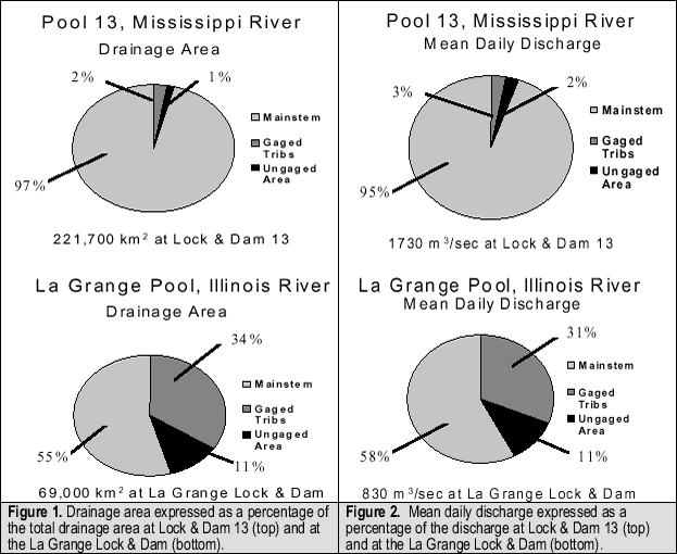
The source and fate of sediments delivered to the Upper Mississippi River System (UMRS) have long been issues of concern. Impoundment by a series of locks and dams, and the associated rise in water level, initially created a highly diverse structural environment of secondary and tertiary channels, considerable bathymetric relief, and numerous islands. Eventually, the impoundment resulted in the simplification of that structural diversity. In the 60 years since impoundment, channels have filled in, bathymetric relief has been reduced and islands have been lost to erosion. The Environmental Management Technical Center, in cooperation with the Water Resources Division of the U.S. Geological Survey (USGS, Illinois and Iowa Districts) and the states of Illinois and Iowa, selected Pool 13 on the Mississippi River and the La Grange Pool on the Illinois River as the initial sites to develop pool-scale suspended sediment budgets. Developing a sediment budget is a necessary first step in understanding the future geomorphology of a navigation pool. Each pool was allocated six gaging sites, one upstream of the pool on the mainstem river (either the Illinois or Mississippi River), one downstream of the pool, and one on each of the four major tributaries to the pool. Discharge gaging and suspended sediment sampling are being conducted according to established USGS methods. Suspended sediment sampling consists of 250 samples per year with samples taken weekly during base flow conditions and more frequently during storm events. Discharge measurements are recorded continuously by automated equipment. This study began in 1994 with site preparation and gage installation. Actual data collection started in 1995 and will end in 1997, after three years of data collection. This amount of time is typically required for developing an adequate sediment budget. The discussion that follows addresses only the data collected during 1995. The drainage area of Pool 13 is dominated by that area drained upstream by the Mississippi River (Figure 1). Very little is contributed by the four gaged tributaries or ungaged area. The dominance of the Mississippi River suggests that the water and sediment budget for Pool 13 will be primarily influenced by events and conditions above the pool while conditions directly surrounding the pool will have a lesser impact. The relationship between the mainstem and local drainage areas are markedly different for the La Grange Pool (Figure 1). The Illinois River drains only 55% of the pool’s total drainage area with the remaining 45% being local or direct. This implies that the water and sediment budgets for the La Grange Pool will be much more influenced by local conditions (storms, land use patterns, etc.) than Pool 13. |
 |
|
Discharge (water flow to and from the pools) exhibits a pattern similar to drainage area. Discharge to Pool 13 is predominantly (95%) provided by the Mississippi River (Figure 2). In contrast, the La Grange receives only 58% of its water from the Illinois River (Figure 2) with the remainder coming directly from the area surrounding the pool. Pool 13 exported almost 10 million kilograms (1100 tons) of suspended
sediment on a daily basis from Lock and Dam 13 (Figure 3). The majority
(67%) of this sediment is supplied by the Mississippi River above
Pool 13. While the gaged tributaries only accounted for 3% of the
drainage area and discharge, they provided 14% of the total load.
The La Grange Pool exported nearly 14 million kilograms (1500 tons)
of suspended sediment on a daily basis from the La Grange Lock and
Dam (Figure 3). |
|
Data collected in 1996 and 1997 should help clarify the differences between these two pools and provide an estimate of their sediment retention rates. Additional sediment studies are planned for navigation pools 8 and 26 of the UMRS. Site preparation and gage installation are scheduled for 1997 followed by data collection in 1998. |
|
This report is a product of the Long Term Resource Monitoring Program for the Upper Mississippi River System. For further information, contact Dr. Robert F. Gaugush Project Status Reports (PSRs) are preliminary documents whose purpose is to provide information on scientific activities. Because PSRs are only subject to internal peer review, they may not be cited. Use of trade names does not imply U.S. Government endorsement of commercial products. All Project Status Reports are accessible through the Upper Midwest Environmental Sciences Center’s website at http://umesc.usgs.gov/reports_publications/psrs/umesc_psr.html |
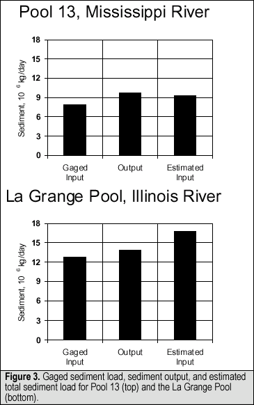 The
Illinois River above the La Grange Pool only accounted for 22% of
this load whereas its contribution to drainage area and discharge
were 55% and 58%, respectively. Gaged tributaries accounted for
71% of the total load. This is much more than would have been expected
given their contribution to the drainage area (34%) and discharge
(31%).
The
Illinois River above the La Grange Pool only accounted for 22% of
this load whereas its contribution to drainage area and discharge
were 55% and 58%, respectively. Gaged tributaries accounted for
71% of the total load. This is much more than would have been expected
given their contribution to the drainage area (34%) and discharge
(31%).Page Last Modified: April 17, 2018