
|
PSR 97-09 August 1997 Bathymetry Data for the Upper Mississippi Riverby James T. Rogala |
|||
|
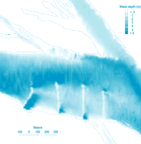
Water depth is an important feature of aquatic systems. On the Upper Mississippi River System (UMRS), water depth data is important for describing the physical template of the system and monitoring changes in this template caused by sedimentation. Although limited point or transect sampling of water depth can provide valuable information on habitat character in the UMRS as a whole, the generation of bathymetric maps is critical for conducting spatial inventories of the aquatic habitat. The maps are also useful for detecting bed elevation changes in a spatial manner as opposed to the more common method of measuring changes along transects. We have collected bathymetric data for map generation since 1989 as part of the Long Term Resource Monitoring Program (LTRMP). Geographical positions and digitized depth soundings are collected simultaneously from an automated survey boat. Recently, we acquired a survey system that uses a Global Positioning System receiver to collect position data. As the boat traverses a survey area, data are recorded about every second at spatial intervals small enough to represent the morphometry of the area. An on-board computer records the data, which are returned to the office for editing. For Pool 8, over 500,000 data points were obtained by these surveys. These point data are supplemented by contours drawn from transect data and by shoreline data obtained from photo interpretation. All of these data, along with additional data to aid interpolation between actual data points, are entered into a Geographical Information System (GIS) and a continuous surface is developed by interpolation. Data are stored as GIS Grid coverages in Arc/Info. The data can be converted to other formats such as data along transect lines or at various cell sizes to reduce the density of data. The data can also be converted to an ASCII file of x and y coordinates and water depth. Arc/Info computer programs have been written to perform a variety of these conversions. In addition, a program has been written to convert the coverages stored as water depths at a low water surface elevation to water depths at various discharge conditions. However, water depths in normally terrestrial areas can not be estimated due to the lack of terrestrial elevation data. Maps from these data can be plotted in a variety of ways. The figure is one example. |
|||
|
|||
|
Pool-wide coverage exists for Pools 4, 8, 13, and 26 of the Mississippi River and the LaGrange Pool on the Illinois River. Data for some additional areas also exists. In addition to the bathymetry coverage, a GIS coverage of the location of actual data points is generated to provide the user with a means to assess the interpolated coverage. The bathymetric data have been widely used for activities such as studies of water level management alternatives, modeling of navigation impacts, modeling hydraulic conditions, conducting an adaptive environmental assessment, and a variety of studies ranging from paddlefish movements to vegetation distribution patterns. In addition to the interpolated coverages in the selected reaches, we have also completed transect surveys of the main channel at one mile intervals for most of the UMRS. The transect data were entered into a GIS for use by the U.S. Army Corps of Engineers in their Navigation Feasibility studies. For the LTRMP, we plan to collect bathymetric data more aggressively than in recent years, initially concentrating in large backwater lakes throughout the UMRS. We will then extend our surveys into remaining backwaters, secondary and tertiary channels, and main channel borders. The U.S. Army Corps of Engineers districts collect main navigation channel bathymetric data. In addition to bathymetric mapping , we at the LTRMP are conducting more precise surveys of elevations along short transects in backwaters to measure short-term changes in bed elevation. We have also begun to establish a set of transects in the larger impounded areas of pools for change detection over longer periods. With the wide range of spatial and temporal resolution of these data, the LTRMP database will not only be able to provide bathymetric data for habitat inventories, but provide valuable information on sedimentation rates for the UMRS. |
|||
|
This report is a product of the Long Term Resource Monitoring Program for the Upper Mississippi River System. For further information, contact James T. Rogala Project Status Reports (PSRs) are preliminary documents whose purpose is to provide information on scientific activities. Because PSRs are only subject to internal peer review, they may not be cited. Use of trade names does not imply U.S. Government endorsement of commercial products. All Project Status Reports are accessible through the Upper Midwest Environmental Sciences Center’s website at http://umesc.usgs.gov/reports_publications/psrs/umesc_psr.html |
Page Last Modified: April 17, 2018