
|
PSR 97-08 July 1997 Estimating Fetch for Navigation Pools in the Upper Mississippi River Using a Geographic Information Systemby James T. Rogala |
||
|
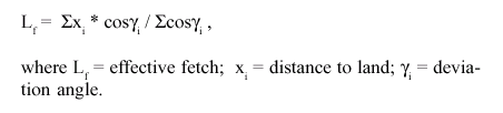
Fetch is the length of water surface exposed to wind during the generation of waves. Fetch is an important characteristic of open water because longer fetch can result in larger wind-generated waves. The larger waves, in turn, can increase shoreline erosion and sediment resuspension. Although this process is more pronounced in waters with little flow, the Upper Mississippi River (UMR) has experienced island loss and high turbidity associated with long fetches. Therefore, fetch data is needed to better assess areas at risk in the UMR because of long fetches. Prior to the development of powerful computer applications such as a Geographic Information System (GIS), calculating fetch was a slow and laborious process. The process required taking manual measurements from paper maps and then inserting those measurements into one of several formulas depending on the type of fetch being estimated. Estimating fetch across an entire pool was impractical given the demands of manually calculating fetches for the many points required for a pool estimate. I wrote two GIS programs to automate the process of calculating effective fetch that can be modified to calculate fetch based on other methods. Effective fetch is calculated by taking fetch shape into account. This is done by measuring distances to land for the selected wind direction and each of seven angles spaced 6 degrees apart on both sides of the wind direction. Each of the fifteen measurements are weighted by the cosine of the angle of deviation. Effective fetch is then calculated by dividing the sum of the cosine weighted distances by the sum of the cosine weights as shown in the following equation:
The programs I developed use two methods to calculate effective fetch in the GIS Arc/Info. The first method uses the raster based GRID module to calculate fetch for all water “cells” in a pool. This method can not replicate the accuracy obtained in the actual polygon data of a vector GIS coverage. A cell size of 50 meters on a side yielded mean errors of around 20 percent. I was able to acheive a lower mean error of 5 percent with 20 meter cells, which was found to be more accurate than hand calculations at a scale of 1:32,500. Smaller cells would yield lower errors, but processing time dramatically increases with smaller cell sizes. The 20 meter cell calculations take over 5 hours to complete for a fetch coverage of a single wind direction for some pools. The second method calculates effective fetch by using polygon data rather than a grid of the data. This method results in no error, but it is so computationally intensive that it can only be used for a limited number of points and pool-wide calculations are not practical. |
||
|
||
|
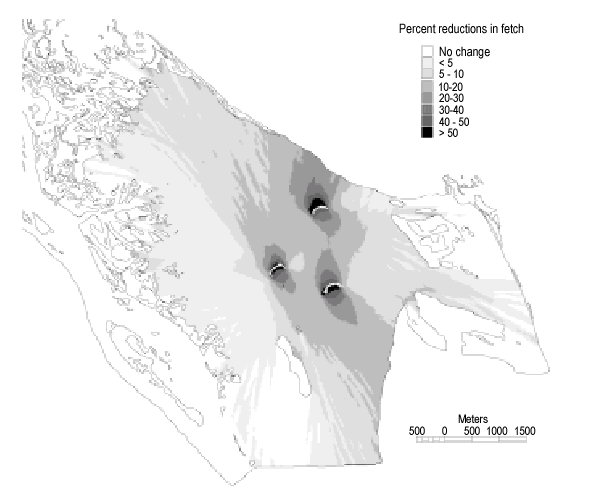
I have calculated effective fetch pool-wide using the grid method for each 45 degree wind direction (eight fetch coverages) for Pools 4, 7, 8, 13, and 26. The fetch coverages for each wind direction can be combined in the GIS in a variety of ways such as: weighting each direction on the basis of occurance during historical periods using weather station records, averaging the eight fetch values, or determining the maximum of the eight fetch values. The programs can be a valuable tool for planning purposes in that alternatives for island construction or projected island loss can be incorporated into the GIS land water coverage and therefore determine differences in fetch. Figure 1 illustrates the reduction in fetch for Lake Onalaska, Pool 7 due to island construction. The program can be used in a similar manner for any pool in the UMR for which a GIS land and water coverage exists. Although I have made only rudimentary attempts at predicting resuspension
based on fetch coverages and historical wind data,
|
||
|
This report is a product of the Long Term Resource Monitoring Program for the Upper Mississippi River System. For further information, contact James T. Rogala Project Status Reports (PSRs) are preliminary documents whose purpose is to provide information on scientific activities. Because PSRs are only subject to internal peer review, they may not be cited. Use of trade names does not imply U.S. Government endorsement of commercial products. All Project Status Reports are accessible through the Upper Midwest Environmental Sciences Center’s website at http://umesc.usgs.gov/reports_publications/psrs/umesc_psr.html |
 the
LTRMP has used the fetch coverages to begin to understand wind-generated
wave effects in some cases. One example is the use of the data in
an empirical model developed by Dr. Robert Gaugush of EMTC to map
zones of sediment dynamics in Lake Onalaska. In another example,
I combined the fetch data to create mean and maximum fetch coverages
to be included as a morphometric measure in a comparative summary
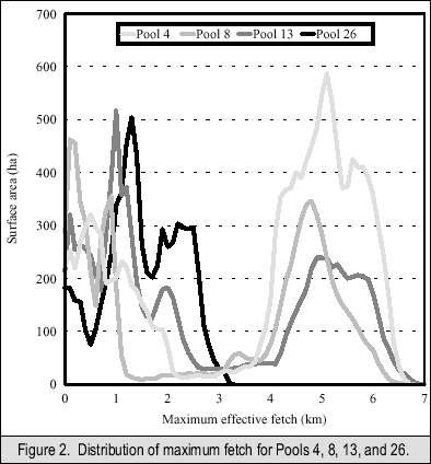
of Pools 4, 8, 13, and 26. Figure 2 illustrates the differences
in distribution of maximum fetch for the four pools. In both these
examples, the use of the effective fetch method rather than other
fetch methods is not as critical as it would be if we were to use
fetch measurements to calculate wave characteristics. Other methods
of fetch calculation, and verification with actual data, would be
needed to go beyond our current use of fetch data.
the
LTRMP has used the fetch coverages to begin to understand wind-generated
wave effects in some cases. One example is the use of the data in
an empirical model developed by Dr. Robert Gaugush of EMTC to map
zones of sediment dynamics in Lake Onalaska. In another example,
I combined the fetch data to create mean and maximum fetch coverages
to be included as a morphometric measure in a comparative summary
of Pools 4, 8, 13, and 26. Figure 2 illustrates the differences
in distribution of maximum fetch for the four pools. In both these
examples, the use of the effective fetch method rather than other
fetch methods is not as critical as it would be if we were to use
fetch measurements to calculate wave characteristics. Other methods
of fetch calculation, and verification with actual data, would be
needed to go beyond our current use of fetch data.Page Last Modified: April 17, 2018