
|
PSR 97-06 June 1997 Using Historical Data to Evaluate the Ecological Integrity of the Upper Mississippi River Systemby John C. Nelson,1 Larry Robinson,2 Lynne DeHaan,2 and Mel Bower2 |
||
|
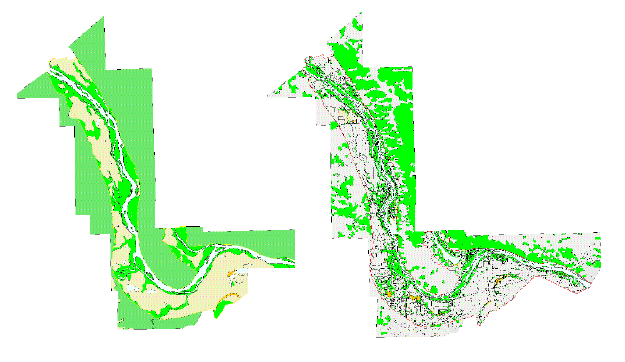
Almost 200 years of modern human activity has dramatically changed the floodplain ecosystem of the Upper Mississippi River System (UMRS). We have no actual picture of what the UMRS and its floodplain looked like before major settlement of the region, but history and science can create a reasonably accurate picture for us. Combining pre-steamboat era records of the U.S. General Land Office (GLO) surveys with the technology of geographic information systems (GIS), researchers of the Long Term Resource Monitoring Program have produced pictures of what selected reaches of the floodplain looked like 200 or more years ago. The pictures help us understand the landscape and plant community characteristics that made the UMRS so biologically rich and help determine how much change has taken place. Historical data are critical for understanding which aspects of the river ecosystem have been most affected by human activity. Some landscapes have been so altered that it is difficult to even imagine their presettlement characteristics. On the other hand, some areas along the UMRS likely possess many presettlement characteristics. Before the ecological integrity of the UMRS can be assessed, it is first necessary to understand what the UMRS looked like and to identify those processes that shaped it before modern human intervention. The 19th century plat maps created by the GLO surveys contain landcover information such as land-water boundaries, timber, prairies, marshes, barrens, and swamps. The EMTC has successfully transferred some plat map data using modern USGS quadrangle maps and a Zoom Transfer Scope (ZTS). The ZTS allows a cartographer to superimpose and align two map images, greatly reducing any distortion inherent to a particular plat map. To our knowledge, this is a new analysis technique and represents the most accurate method for quantifying presettlement land covers. The final step in creating a presettlement map is digitization and data storage in a GIS. Field notes that accompany each plat map list the types of trees used to witness surveyed corner posts. The witness tree data are used to reconstruct the composition and structure of presettlement plant communities. Unlike most historical descriptions, the methods employed by the GLO provide quantifiable data that can be used as a baseline from which we can accurately estimate change. |
||
|
||
|
According to GLO surveys performed in 1816, prairie communities dominated the floodplain along Mississippi River Reaches 25 and 26 (see figure). This finding contradicts many other small-scale presettlement maps that indicate forest as the dominant vegetation type along most rivers within the prairie peninsula. While the GLO surveyors did not identify any of the prairie plants they encountered, they did apply the terms “wet” and “dry” to their descriptions of the prairies. Some groves of timber were also recorded in field notes within the predominantly open floodplain prairies. The distances measured to witness trees indicate these groves had the appearance of savanna and woodland communities. Ecologists studying presettlement vegetation patterns in the uplands of the midwest have long attributed the development and maintenance of prairies, oak savannas, and oak woodlands to disturbance by fire. On the floodplain in 1816 , pin oak was the dominant tree species, followed by elm, cottonwood, hackberry, silver maple, white oak, and hickory. The dominance of prairie and the high importance of oak and hickory during the presettlement may indicate that fires swept down from the uplands and onto and across the floodplain. In contrast, dense forest communities dominated the islands and other low-lying areas where flooding was presumably the primary disturbance mechanism. Today’s landscape is quite different from the presettlement. Floodplain prairies are the most severely impacted plant communities. Due to their conversion to agriculture, only 6% of today’s river-floodplain has grass/ forb cover compared to 47% in 1816. Timberlands have been less impacted than the prairies. Today, timber still covers 19% of the river-floodplain, approximately half of its presettlement coverage (35%). While timberlands are still substantial along river reaches 25 and 26, they are often fragmented and contain fewer early successional species such as cottonwood and oak. Silver maple has become the dominant species in many floodplain forests—a change similar to many upland forests of the midwest that are being successionally replaced by silver maple’s cousin, the sugar maple. Some people might regard the changes over the past 200 years as another reminder of the harmful ways we have altered the environment. They should take some comfort in knowing that many areas with high quality habitats remain intact along the UMRS. Some of these areas have been preserved within private hunting clubs, while others reside in state and federal wildlife management areas. Opportunities do exist to restore some of the prairies, savannas, and woodlands that have been lost due to the plow, logging, and river impoundment. The use of historical GLO survey data to reconstruct a picture of the past is an example of the LTRMP’s commitment to developing a better understanding of the ecology of the UMRS and its resource problems. Current annual work plan goals of the LTRMP include creating presettlement GIS land cover maps for Mississippi River Reaches 4, 8, 13, 17, 25, 26, and the Open River, as well as the LaGrange Reach of the Illinois River. Concurrent with map preparation at the EMTC, witness tree data are being collected, compiled and analyzed at the LTRMP Alton Field Station of the Illinois Natural History Survey. |
||
|
1Illinois Natural History Survey, LTRMP
Alton Field Station |
||
|
This report is a product of the Long Term Resource Monitoring Program for the Upper Mississippi River System. For further information, contact 2U.S. Geological Survey Project Status Reports (PSRs) are preliminary documents whose purpose is to provide information on scientific activities. Because PSRs are only subject to internal peer review, they may not be cited. Use of trade names does not imply U.S. Government endorsement of commercial products. All Project Status Reports are accessible through the Upper Midwest Environmental Sciences Center’s website at http://umesc.usgs.gov/reports_publications/psrs/umesc_psr.html |
Page Last Modified: April 17, 2018