
|
PSR 97-05 May 1997 Evaluation Of The Hydice Sensor For Mapping Floodplain Vegetation In Navigation Pool 13, Upper Mississippi River Systemby Dr. Prasanna H. Gowda |
|
Efficient inventories of natural systems such as forest, wetland, and floodplain ecosystems are required to ensure sustainability. Current remote sensing technologies allow the monitoring of several aspects of natural systems on the surface of the earth at various levels of detail. Desire for more frequent updates of such inventories and the need for evaluating their accuracy have demanded high resolution remote sensing data. In recent years, ecologists have started using Geographic Information Systems (GIS) as a tool for understanding spatial and temporal distribution of ecosystem processes. However, their use of GIS is confined by the lack of suitable spatial data bases. Satellite remote sensing has provided required spatial data to some extent, however, only at regional and subcontinental scales. It lacks the spatial, spectral and radiometric resolutions needed for discriminating finer scale ecological processes. In addition, the users of remotely sensed data demand timely data availability, better quality assurance, and reliable data standards. In response, many airborne hyperspectral sensors with very high spatial, spectral, and radiometric resolutions have been developed by both public and private enterprises as an alternative to satellite data. Hyperspectral imagery refers to an image acquired over a large number of discrete, contiguous spectral bands such that a complete reflectance spectrum can be obtained for the region being imaged. The objective of this research was to evaluate the Hyperspectral Digital Imagery Collection Experiment (HYDICE) sensor for mapping flood-plain vegetation. The HYDICE sensor is a second generation, “state-of-the-art,” nadir-viewing, push broom, high resolution airborne imaging spectroradiometer. This sensor system was developed by the Hughes Danbury Optical Systems in coordination with the Naval Research Laboratory and funded by the U.S. Government.
|
|
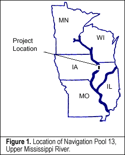
A 16-bit hyperspectral image with 4-meter spatial resolution acquired on June 19, 1995 was used for evaluating the HYDICE sensor. Ground truth data were collected for understanding the spectral behavior of floodplain features at a given spectral resolution. Reflection spectra for floodplain features at known locations were extracted from the HYDICE data for spectral analysis as well as for developing a reference spectral database that can be used with advanced feature identification techniques. Based on the visual comparison of derived reflection spectra, a set of bands was selected to eliminate redundant bands and thus reduce the computer processing time required for landcover classification. Both unsupervised and supervised classification techniques were used for developing landcover maps. For unsupervised classification, a set of 100 spectral classes was identified and then, informational classes were assigned to each of the spectral classes for obtaining a final landcover classification system. A spectral database consisting of reflection spectra for various
floodplain features were extracted from the HYDICE data. A set of
7 bands out of 210 bands was selected based on an individual bands’
ability to discriminate floodplain features. Two land cover maps
were developed for the Potter’s Marsh area using unsupervised
and supervised classification techniques and were then evaluated.
|
|
This report is a product of the Long Term Resource Monitoring Program for the Upper Mississippi River System. For further information, contact Dr. Prasanna H. Gowda U.S. Geological Survey Project Status Reports (PSRs) are preliminary documents whose purpose is to provide information on scientific activities. Because PSRs are only subject to internal peer review, they may not be cited. Use of trade names does not imply U.S. Government endorsement of commercial products. All Project Status Reports are accessible through the Upper Midwest Environmental Sciences Center’s website at http://umesc.usgs.gov/reports_publications/psrs/umesc_psr.html |
 The
HYDICE sensor is mounted on a CV-580 aircraft. Hyperspectral data
are collected and distributed by the Hyperspectral Program Office
of the Naval Research Laboratory. The sensor was intended for various
purposes such as evaluations of vegetation, water quality, bathymetry,
and minerals. The spatial resolution varies from 1 to 4 meters depending
on the aircraft’s altitude above ground level, and the spectral
resolution includes 210 contiguous bandwidths from the visible to
shortwave infrared (400-2500 nm).
The
HYDICE sensor is mounted on a CV-580 aircraft. Hyperspectral data
are collected and distributed by the Hyperspectral Program Office
of the Naval Research Laboratory. The sensor was intended for various
purposes such as evaluations of vegetation, water quality, bathymetry,
and minerals. The spatial resolution varies from 1 to 4 meters depending
on the aircraft’s altitude above ground level, and the spectral
resolution includes 210 contiguous bandwidths from the visible to
shortwave infrared (400-2500 nm).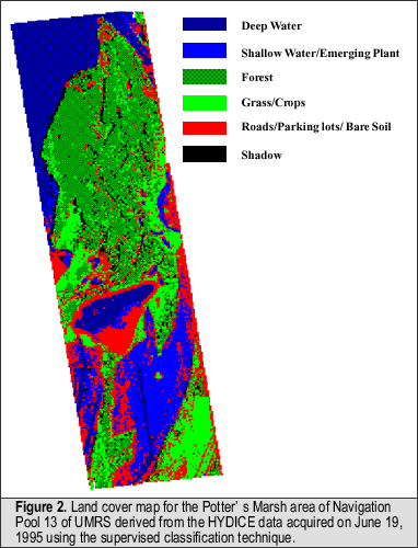 The
landcover map derived using the unsupervised classification technique
was unable to clearly discriminate shadows from shallow water.
The
landcover map derived using the unsupervised classification technique
was unable to clearly discriminate shadows from shallow water.Page Last Modified: April 17, 2018