|
At the request of the Fish and Wildlife Interagency Committee,
the Rock Island District
of the U.S. Army Corps of Engineers (Corps) 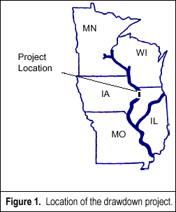 and
the Environmental Management Technical Center are collaborating
to estimate acreages that would be affected by a water-level drawdown
in Mississippi
River Pool 13 (see Figure 1). The potential drawdown is intended
to increase moist soil plant production, sediment oxidation and
compaction, and to expand the photic zone for submersed vegetation.
Acreage estimates of dewatered areas are needed to help define benefits
before the current operating plan for Pool 13 can be modified. The
drawdown may occur as early as the summer of 1998 if hydrologic
conditions are appropriate. and
the Environmental Management Technical Center are collaborating
to estimate acreages that would be affected by a water-level drawdown
in Mississippi
River Pool 13 (see Figure 1). The potential drawdown is intended
to increase moist soil plant production, sediment oxidation and
compaction, and to expand the photic zone for submersed vegetation.
Acreage estimates of dewatered areas are needed to help define benefits
before the current operating plan for Pool 13 can be modified. The
drawdown may occur as early as the summer of 1998 if hydrologic
conditions are appropriate.
Because the river is used for multiple purposes, several constraints
limit the maximum drawdown depth. Our study assumes the following:
channel dimensions of 400 ft wide and 10.5 ft deep must be available
for the entire pool at all discharges; the drawdown should not significantly
affect commercial navigation or recreational craft; and no additional
dredging should be required. These constraints limit the effective
zone of influence and the chance of a successful drawdown. By investigating
channel geometry, channel depths at a range of discharges throughout
the pool, and discharge records, the Corps found that a 1 ft drawdown
at the dam would be possible at discharges between 50,000 cfs and
110,000 cfs. 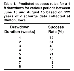 At
discharges below 50,000 cfs, a 1 ft draw-down would violate the
depth constraint without additional dredging. A draw-down at flows
greater than 110,000 cfs would not be possible since open river
conditions would prevail. The predicted success rate for discharges
in this range is related to the length of the drawdown period and
can be calculated from historical records. Based on an evaluation
of historical flow records, success rates for a 1 ft drawdown, occurring
between June 15 and August 15, are given in Table 1. At
discharges below 50,000 cfs, a 1 ft draw-down would violate the
depth constraint without additional dredging. A draw-down at flows
greater than 110,000 cfs would not be possible since open river
conditions would prevail. The predicted success rate for discharges
in this range is related to the length of the drawdown period and
can be calculated from historical records. Based on an evaluation
of historical flow records, success rates for a 1 ft drawdown, occurring
between June 15 and August 15, are given in Table 1.
A one-dimensional flow model (UNET) was used to predict water surface
profiles and water velocities under steady flow conditions. The
model pre dicted that the effect of a 1ft drawdown at the dam decreases
upriver and also decreases with an increase in discharge. The drawdown
would be less than 0.3 ft at discharges between 50,000 cfs and 110,000
cfs at all points which are more than 11 mi upriver (river mile
534) of the dam. Eight miles upriver of the dam the drawdown would
be about 0.6 ft at a discharge of 50,000 cfs and about 0.3 ft at
a discharge of 110,000 cfs. Predicted increases in water velocities
were under 0.2 ft/s except for the area within 3 mi of the dam.
Near the dam water velocities would increase as much as 0.4 ft/s.
|
|
Water surfaces predicted by the UNET model at 50,000 cfs were then
transformed into a map using a template with sections approximately
1 mi long. 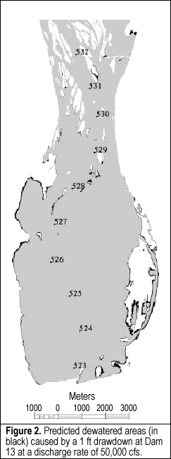 Because
the Spring Lake area in lower Pool 13 is protected by a levee, the
model assumed that water levels there would be controlled by water
levels at river mile 532. The water surface template was then overlaid
with a bathymetric map. Data for the bathymetric map were collected
between 1989 and 1993, and include only areas that are considered
aquatic. The Rock Island District’s Channel Maintenance Section
is planning to conduct a complete channel survey in 1997 to update
older bathymetric data. Once these data become available, critical
channel locations limiting the maximum depth of drawdown will be
recomputed. Because
the Spring Lake area in lower Pool 13 is protected by a levee, the
model assumed that water levels there would be controlled by water
levels at river mile 532. The water surface template was then overlaid
with a bathymetric map. Data for the bathymetric map were collected
between 1989 and 1993, and include only areas that are considered
aquatic. The Rock Island District’s Channel Maintenance Section
is planning to conduct a complete channel survey in 1997 to update
older bathymetric data. Once these data become available, critical
channel locations limiting the maximum depth of drawdown will be
recomputed.
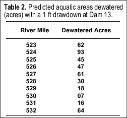
A geographic information system was used to predict areas dewatered
by a 1 ft drawdown. The only aquatic areas predicted to be dewatered
occur between river miles 523 and 532 because the river is severely
constricted at mile 533, limiting the effect of drawdowns upriver
of this point. The total aquatic area dewatered with a 1 ft drawdown,
443 acres, are presented in Table 2 and shown in Figure 2. We also
estimated that 1070 acres of aquatic areas would be dewatered if
a 2 ft drawdown could be achieved. Dewatered acreage estimates for
areas that are not considered aquatic could not be obtained because
accurate elevation data for terrestrial areas are not available.
Thus the total area affected by a 1 ft drawdown at the dam will
be greater than 443 acres.
|
|
This report is a product of the Long Term
Resource Monitoring Program for the Upper Mississippi River
System.
For further information, contact
Joseph
H. Wlosinski or James T. Rogala
1U.S. Geological Survey
Upper Midwest Environmental Sciences Center
575 Lester Avenue
Onalaska, Wisconsin 54650
Phone: 608/783-7550, ext. 56
E-Mail: Joe_Wlosinski@usgs.gov
E-Mail: Jim_Rogala@usgs.gov
Project Status Reports (PSRs) are preliminary documents whose purpose
is to provide information on scientific activities. Because PSRs
are only subject to internal peer review, they may not be cited.
Use of trade names does not imply U.S. Government endorsement of
commercial products.
All Project Status Reports are accessible through the Upper Midwest
Environmental Sciences Center’s website at http://umesc.usgs.gov/reports_publications/psrs/umesc_psr.html
|
