
|
PSR 96-03 October 1996 Predicting the Effects of Water Level Management Optionsby Joseph H. Wlosinski and James T. Rogala |
|
Twenty-seven dams and hundreds of miles of levees affect floodplain habitat in the Upper Mississippi River floodplain. Predicting areas of the floodplain that may be wetted or dried has been difficult because water levels at the dams are managed as a function of discharge. This causes the slope of the water surface in the navigation pools to routinely vary over the year from less than a foot to over 8 feet. Environmental Management Technical Center staff have integrated hydraulic, statistical, and spatial models to predict the effects of management alternatives for Pool 25 on the Upper Mississippi River. Pool 25 has been the focus of an interagency committee on natural resources for the past 3 years. The model framework, which includes options dealing with levee placement and water level management at the dams, can be easily applied to other areas on the system as data become available. For example, the spatial model is currently being used by the St. Paul District to predict the effects of management options on habitat in Pool 8. A report on that project is scheduled for this year. The models 1) estimate how often a particular water level management plan may be practical based on the historical water surface elevation record and discharge estimates, 2) predict types and amounts of habitat affected by various water level and levee management alternatives, 3) estimate changes to the aquatic terrestrial transition zone (ATTZ) caused by dam operation and levee placement, and 4) estimate flood easement or ownership rights needed for various options. |
|
Since 1939, discharge estimates for Pool 25 were used to compute
exceedence frequencies on a weekly, monthly, and yearly basis. Water
level measurements at five stations were used to calculate the percentage
of time water levels were above specific elevations for the same
three time scales. These data were also used to calibrate a one-dimensional
hydrologic model (HEC-2), assuring that predicted water surfaces
were within 0.3 feet of measured values. Bathymetric surveys in
1993 and 1994 provided transect data for the model at 1/2 mile intervals.
|
|
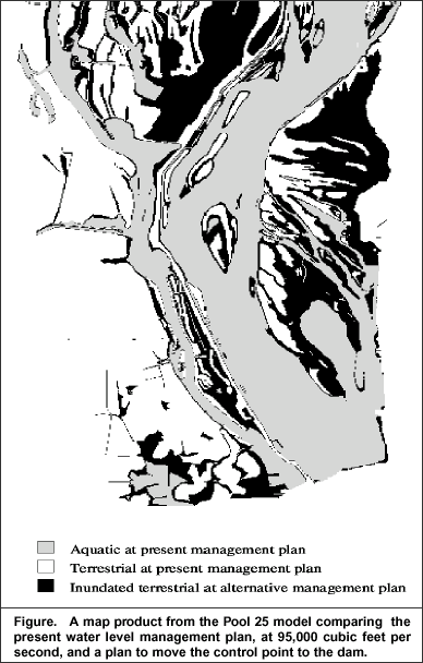
The ATTZ, defined here as the amount of land area flooded between yearly average minimum and maximum water surface elevations, has been studied using the model. The ATTZ has changed considerably as a function of human activities on the floodplain. The areal extent of the ATTZ, both as it is now and as it would be if the dams and levees were not present, was calculated for three 2-mile wide bands representing the lower, middle, and upper reaches of the reservoir. In the lower reach of reservoir, the ATTZ is now only about 2/3 of its original size. In the other two reaches, the ATTZ is now only about 1/3 of its original size. The model was also used to estimate the discharge representing ordinary high water and to predict additional lands that would be flooded as a result of alternative plans. One of the water level management options from the above study is presently being further investigated by the St. Louis District. It involves allowing a flexible control point (a specific location in the reservoir where a water level target is maintained). The major negative impact from this option would be the need for the St. Louis District to purchase additional land or flood easements. The model predicted that no lands would need to be purchased under any discharge for 13 miles immediately upriver of the dam. The maximum amount of land needed would be approximately 740 acres when water levels are maintained at their highest level at the discharge creating ordinary high water. This new plan would not have a detrimental effect on the 9-foot navigation channel and it would provide the management option of allowing for up to 4.3 feet of water level fluctuation for improvement of habitat for some organisms. To quantify the benefits that might be obtained from alternate water management strategies will require appropriate investigations. |
|
|
|
This report is a product of the Long Term Resource Monitoring Program for the Upper Mississippi River System. For further information, contact Joseph H. Wlosinski or James
T. Rogala
Project Status Reports (PSRs) are preliminary documents whose purpose is to provide information on scientific activities. Because PSRs are only subject to internal peer review, they may not be cited. Use of trade names does not imply U.S. Government endorsement of commercial products. All Project Status Reports are accessible through the Upper Midwest Environmental Sciences Center’s website at http://umesc.usgs.gov/reports_publications/psrs/umesc_psr.html |
 The
hydrologic model was used to predict water surfaces for four different
discharge regimes, each for five water level management options.
The present water level management plan was included as one option,
with two options having higher water levels and two lower water
levels than at present.
The
hydrologic model was used to predict water surfaces for four different
discharge regimes, each for five water level management options.
The present water level management plan was included as one option,
with two options having higher water levels and two lower water
levels than at present.Page Last Modified: April 17, 2018