|
Why it is needed
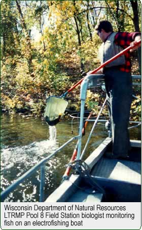 Long Term Resource Monitoring Program (LTRMP)
staff collect fisheries, water quality, vegetation, invertebrate,and
other biological and physical long-term resource trend data on the
Upper Mississippi River System (UMRS). These data are then stored
in a database management system. Spatial data such as land cover/use,
bathymetry, water control infrastructure, ecologically sensitive
areas, human use facilities and areas, water elevations, and other
information are also collected and maintained. The need for scientists
and river managers to view and analyze resource trend data in conjunction
with other spatial data has resulted in the development of a geographic
information system (GIS) application that integrates these data
and provides the capability to spatially subset resource trend data.
Long Term Resource Monitoring Program (LTRMP)
staff collect fisheries, water quality, vegetation, invertebrate,and
other biological and physical long-term resource trend data on the
Upper Mississippi River System (UMRS). These data are then stored
in a database management system. Spatial data such as land cover/use,
bathymetry, water control infrastructure, ecologically sensitive
areas, human use facilities and areas, water elevations, and other
information are also collected and maintained. The need for scientists
and river managers to view and analyze resource trend data in conjunction
with other spatial data has resulted in the development of a geographic
information system (GIS) application that integrates these data
and provides the capability to spatially subset resource trend data.
Vegetation, land use, hydrology, and geomorphic characteristics
vary significantly over the UMRS study area. When integrated with
monitoring data, spatial databases will assist scientists in determining
ecological status and trends and help explain causal relationships.
Because of the sheer magnitude of this effort, automated tools are
required to support such analyses.
|
|
What it is
Using GIS tools, an easy-to-use graphical application has
been developed to spatially query the Long Term Resource Monitoring
Program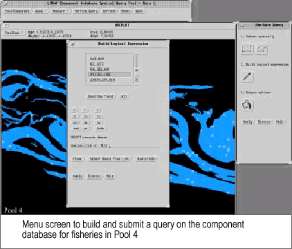 biological database and to display the selected data in conjunction
with other spatial data for viewing, plotting, and analysis. One
of the important features of the Spatial Query Tool is the ability
to define an area spatially, then extract the existing LTRMP data
for that area. Selected information can be exported in a format
compatible with a statistical analysis program such as SAS.
biological database and to display the selected data in conjunction
with other spatial data for viewing, plotting, and analysis. One
of the important features of the Spatial Query Tool is the ability
to define an area spatially, then extract the existing LTRMP data
for that area. Selected information can be exported in a format
compatible with a statistical analysis program such as SAS.
The Spatial Query Tool features a graphical user interface and requires
only basic knowledge of GIS concepts. Proper use of the component
database requires familiarity with the contents and field definitions.
|
|
The application allows the user to select a study pool, a base
map, and resource component, zoom to the area of interest, then
create a spatial subset of sampling sites by graphically defining
a bounding box or polygon. Base maps of land cover, aquatic areas,
or control structures can be displayed. 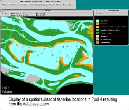 The
user can query the database from selected fields of interest and
apply this query to the spatial subset of the sampling sites. The
selected sampling sites displayed over the selected base data can
be plotted or the information from the database can be used in other
computer programs. The
user can query the database from selected fields of interest and
apply this query to the spatial subset of the sampling sites. The
selected sampling sites displayed over the selected base data can
be plotted or the information from the database can be used in other
computer programs.
Current applications
A user-friendly interactive application to link resource component
trend data with spatial data did not exist prior to this initiative.
The Spatial Query Tool was developed on a UNIX computer platform
to take advantage of the advanced GIS functionality and tools available
in that environment. The application is currently being used by
EMTC and field station component specialists.
What’s next
Once the UNIX version has been fully tested, the Spatial Query Tool
will be adapted to run on a personal computer. This local access
capability will allow expanded use of the application by resource
managers at the field office level.
|
|
This report is a product of the Long Term
Resource Monitoring Program for the Upper Mississippi River
System.
For further information, contact
U.S. Geological Survey
Upper Midwest Environmental Sciences Center
575 Lester Avenue
Onalaska, Wisconsin 54650
Phone: 608/783-7550
Project Status Reports (PSRs) are preliminary documents whose purpose
is to provide information on scientific activities. Because PSRs
are only subject to internal peer review, they may not be cited.
Use of trade names does not imply U.S. Government endorsement of
commercial products.
All Project Status Reports are accessible through the Upper Midwest
Environmental Sciences Center’s website at http://umesc.usgs.gov/reports_publications/psrs/umesc_psr.html
|
