

Upper Midwest Environmental Sciences Center
U.S. Fish & Wildlife Service Partnerships
The USFWS and USGS have had a long and productive combining their expertise to monitor and classify critical wildlife habitat. Below are several projects currently in progress.
Automated Waterfowl Counts:
|
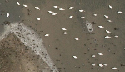
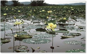
The Upper Mississippi River System (UMRS) is an important stopover for migrating waterfowl in the early-spring and late-fall. Aerial surveys are performed weekly during these visitations to determine the waterfowl species and approximate numbers as well as their preferred feeding habitat. Since 2003, digital aerial photography has been used to supplement these counts and provide precise numbers for selected areas and the vegetation make-up of feeding locations. Once aerial photos are georeferenced, they are converted to 1–bit images comprised of white dots (waterfowl) on a black background (water). Feature Analyst, an object-based feature extraction extension for ArcMap, is used to identify and count the white dots, or pixels, and generate a layer consisting of single points at the center of those pixels. This point layer can then be combined with similarly referenced vegetation and bathymetry layers to help determine resource usage patterns by vegetation types and water depths. For more information, please see the Waterfowl Counts web page. |
Invasive Species:
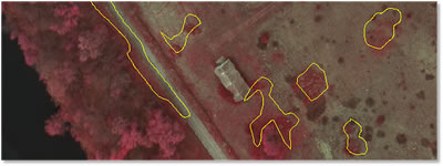
The U.S. Fish & Wildlife Service’s mission is to conserve the nation’s fish, wildlife, and plants. Native ecosystems are constantly evolving as they are being negatively impacted by a multitude of non-native invasive species and become less diverse. The ability to rapidly detect, map, and control or eliminate non-native invasive plants has become a high priority for many NWRs. The USFWS Region 3 and UMESC have collaborated on several invasive species mapping projects of late to determine the best methods for detection and mapping using digital aerial photography at a variety of resolutions. For more information, please see the Invasive Species web page.
|
Comprehensive Conservation Plans:
The Fish and Wildlife Service (USFWS) has been entrusted to manage our nation’s critical wetland resources. Due to conversion in industrial, residential, and agricultural uses, these wetlands have been disappearing at an alarming rate over the last one-hundred years. In order to better care for these resources, all of the refuges are developing long-term Comprehensive Conservation Plans (CCP). An important component of these plans is a detailed baseline of vegetation growing on these refuges. UMESC works closely with both refuge staff and Region Office biologists to develop vegetation classification systems and GIS products that assist in the design and implementation of long-term refuge plans. For more information, please see the Comprehensive Conservation Plans web page.
Impact of UMESC ScienceImplementing new technologies, when cost effective, allows UMESC to continue to increase both the production efficiency and spatial accuracy of its GIS data sets. Points of Contact: Jennifer Dieck and Larry Robinson Mention of trade names or commercial products does not constitute endorsement or recommendation for use by the U.S. Department of Interior, U.S. Geological Survey. |

Page Contact Information: Contacting the Upper Midwest Environmental Sciences Center
Page Last Modified: March 1, 2011