
Application of Wind Fetch and Wave Models for Habitat Rehabilitation and Enhancement ProjectsBy Jason Rohweder, James T. Rogala, Barry L. Johnson, Dennis Anderson, Steve Clark, Ferris Chamberlin, and Kip Runyon
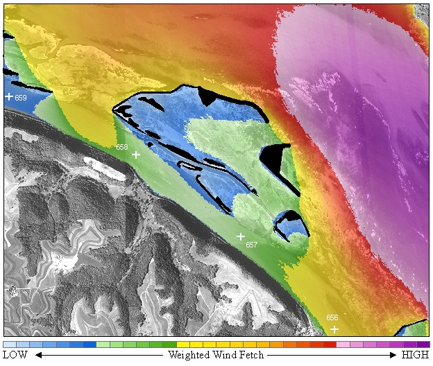
AbstractModels based upon coastal engineering equations have been developed to quantify wind fetch length and several physical wave characteristics including significant height, length, peak period, maximum orbital velocity, and shear stress. These models, developed using Environmental Systems Research Institute’s ArcGIS 9.2 Geographic Information System platform, were used to quantify differences in proposed island construction designs for three Habitat Rehabilitation and Enhancement Projects in the U.S. Army Corps of Engineers St. Paul District (Capoli Slough and Harpers Slough) and St. Louis District (Swan Lake). Weighted wind fetch was calculated using land cover data supplied by the Long Term Resource Monitoring (LTRM) for each island design scenario for all three HREPs. Figures and graphs were created to depict the results of this analysis. The difference in weighted wind fetch from existing conditions to each potential future island design was calculated for Capoli and Harpers Slough HREPs. A simplistic method for calculating sediment suspension probability was also applied to the HREPs in the St. Paul District. This analysis involved determining the percentage of days that maximum orbital wave velocity calculated over the growing seasons of 2002-2007 exceeded a threshold value taken from the literature where fine unconsolidated sediments may become suspended. This analysis also evaluated the difference in sediment suspension probability from existing conditions to the potential island designs. Bathymetric data used in the analysis were collected from the LTRM and wind direction and magnitude data were collected from the National Oceanic and Atmospheric Administration, National Climatic Data Center. IntroductionThe St. Paul District and the St. Louis District of the U.S. Army Corps of Engineers (USACE) tasked the Upper Midwest Environmental Sciences Center (UMESC) of the U.S. Geological Survey (USGS) with the development of geospatial models based on wind and water depths to assist in the planning for Habitat Rehabilitation and Enhancement Projects (HREP), under the Environmental Management Program. This work is part of a project to better utilize Long Term Resource Monitoring (LTRM) data and scientific expertise at UMESC for HREP activities. Wind Fetch ModelWind fetch is defined as the unobstructed distance that wind can travel over water in a constant direction. Fetch is an important characteristic of open water because longer fetch can result in larger wind-generated waves. The larger waves, in turn, can increase shoreline erosion and sediment resuspension. Wind fetches in this model were calculated using scripts designed by David Finlayson, U. S. Geological Survey, Pacific Science Center, while he was a Ph.D. student at the University of Washington (Finlayson 2005). This method calculates effective fetch using the recommended procedure of the Shore Protection Manual (USACE 1984). The wind fetch scripts that the model operates from were developed by Finlayson using the Python scripting language and were originally designed to run on the ArcGIS 9.0 (Environmental Systems Research Institute ([ESRI] Redlands, California) Geographic Information System (GIS) platform. However, these scripts needed to be updated in order to operate using the most current ArcGIS revision, 9.2. The model was also modified to calculate wind fetch for multiple wind directions based upon a text file listing individual compass directions. Also, another wind fetch calculation method “SPM-Restricted” was added to the existing model. This more restricted method for calculating effective fetch may be more appropriate when the habitat project of interest has long and narrow fetches (Smith 1991). Wave ModelA model was constructed within ArcGIS 9.2 to create several useful wave outputs. Significant wave height, wave length, spectral peak wave period, shear stress, and maximum orbital wave velocity can all be calculated using this model according to equations taken from the USACE Shore Protection Manual (USACE 1984) and the USACE Coastal Engineering Manual (USACE 2002). This model uses wind fetch, wind direction, wind speed, and bathymetric data as inputs to calculate these wave outputs. Download Wind Fetch and Wave Models
To use the wind fetch and wave models, there are some preliminary steps that need to be followed for them to function correctly on the computer. First are a few software requirements that need to be met:
Pywin32 (Python for Windows extension) References CitedFinlayson, D. 2005, david.p.finlayson - Puget Sound Fetch. School of Oceanography, University of Washington, Seattle, WA. Smith, J.M., 1991, Wind-wave generation on restricted fetches. U.S. Army Engineer Waterways Experiment Station, Misc. Paper CERC-91-2, 25pp. U.S. Army Corps of Engineers (USACE), 1977, Shore Protection Manual, Third Edition. Coastal Engineering Research Center, Fort Belvoir, Virginia. USACE, 1984. Shore Protection Manual, Coastal Engineering Research Center, Fort Belvoir, Virginia. USACE, 2002, Coastal Engineering Manual, Engineer Manual 1110-2-1100, U.S. Army Corps of Engineers, Washington, D.C. (in 6 volumes). Impact of UMESC ScienceThe ability to quantify the physical impact of wind, and subsequently, wave energy has become an important tool for analyzing aquatic habitats. The refinement and application of these tools gives researchers and resource managers the capability to better design habitat rehabilitation structures and predict their effect.This project was completed in 2008. Please direct problems downloading files to Jason Rohweder. |
|||||||||
Page Last Modified: April 17, 2018