

Upper Midwest Environmental Sciences Center
Scope of Work
![]()
Introduction
This Scope of work identifies the organizational structure and principle operating guidelines that will be utilized throughout the process of preparing a Habitat Needs Assessment (HNA) for the Upper Mississippi River System (UMRS). This guidance focuses on addressing the overall direction of this effort and is prescriptive in nature. This work will be managed using the United States Army Corps of Engineers, Program and Project Management Business Process, this includes the development of a Project Management Plan (PMP). The PMP is a dynamic document that will be updated biannually (February & August).
Objective
The objective of this effort (HNA) is to evaluate past conditions in order to understand habitat forming processes likely to determine future habitat conditions, existing habitat conditions throughout the UMRS, prepare a forecast of future habitat conditions, and quantification of desired future habitat conditions. This effort will address habitat needs at the system-wide, river reach, and pool scales. This HNA will be principally used, to guide in the selection, design, and evaluation of habitat restoration and protection projects under a reauthorized EMP. It will begin to identify long-term habitat requirements and serve to refine the focus of future system monitoring and research activities under the LTRM element of a reauthorized EMP.
Geographic Scope and Scales
The Water Resources Development Act of 1986, defined the UMRS to include 1) the Mississippi River from Cairo, IL (rm. 0) to Minneapolis, MN (rm. 853), 2) the Illinois River and Waterway (rm. 0-218), and 3) portions of four tributaries: the Minnesota River, MN (rm. 0-26); Black River, WI (rm. 0- 1.4); St. Croix River, MN (rm. 0-25); and Kaskaskia River, IL (rm. 0-35). The HNA will address system-wide habitat needs in the two mainstem river corridors and four tributaries, totaling 1,158 river miles. All aquatic and floodplain terrestrial habitats, including channels, impounded areas, backwaters and floodplains (bluff to bluff) will be addressed were data is available in a readily assessable format. The HNA will provide a system-wide, river reach, and pool scale framework for selection of future habitat restoration and protection projects.
Procedure
Habitat needs will be identified through comparison of past, current (or existing), forecast future and desired future conditions. Existing spatial data from the Long Term Resource Monitoring Program (LTRMP) for the Upper Mississippi River System and Corps of Engineers GIS databases will be extensively used in the HNA. Organism/habitat information will be organized by species guilds or groups of species with similar life requisites. Information on habitat types will be organized using an expanded Long-Term Resource Monitoring Program (LTRMP) habitat classification, including hydrologic determinates of habitat, relying on existing GIS data. GIS databases for the HNA will be developed collaboratively by the Corps, U.S. Geological Survey Biological Resources (USGS), U.S. Fish and Wildlife Service (USFWS), and the UMRS states, with files served through an interactive Internet site. A survey of public expectations for desired future condition of UMRS habitats will be conducted, as well as innn n tegrating public involvement efforts from the Great River SIMM and UMRCC O&M Report to the extent possible.
Budget and Schedule
The estimated initial first cost of the HNA should not exceed $1,000,000 (This cost does not include in-kind services provided by HNA participating agencies or organizations, or the cost of periodic updates to keep the HNA current). The HNA is scheduled to be completed by September 2000.
The preliminary milestones are:
-
30 November 1998 - Complete Scope of Work
30 November 1998 - Organizational Structure & Committee Membership Established
16 February 1999 - Draft Work Plans completed (from each committee)
1 March 1999 - Review of Draft Work Plans and Revision of PMP (Comments back to Committee)
30 March 1999 - Final Work Plans completed from each committee
20 April 1999 - Preparation of Final PMP
15 May 1999 - Approval of PMP
30 November 1999 - 50% Review of HNA
30 June 2000 - Complete draft report by HNA team
30 July 2000 - Complete Review of Draft Report by HNA Partners
30 August 2000 - Final report of St. Louis District Commander
30 September 2000 - Approval of report by Commander, Mississippi Valley Division
Organizational Structure
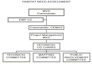
The HNA will be accomplished through committees led by a project manager (PM) assigned to the St. Louis District Commander. The PM will be responsible to the team and St. Louis District commander to ensure a high quality product is delivered on time and within budget (Reference Figure 1). The U.S. Fish and Wildlife Service will assist the Corps in conducting the study by providing a technical co-chair from its Rock Island Field Office who will work closely with a Corps co-chair from the St. Paul District.
Three working committees will be utilized in preparing the HNA. A Technical Committee will have the task of identifying the physical and biological habitat needs. A Mapping Committee will gather cartographic and statistical information and provide mapping and data. (note: The Technical and Mapping Committees were later combined.) There will be a Public Involvement Committee to ensure broad-based public understanding and involvement in this effort. A breakdown of Points of Contact and Committee Chairpersons is presented in Appendix A of this SOW.
A variety of information transfer techniques will be employed to provide information to the public and interested agencies and organizations. An Internet HNA home page will be established, which will provide study description, updates, visualization products, and will serve GIS files. Progress on the HNA will be reported through the EMP-CC. A completion report will be published, and will be served on the Internet HNA home page.
The HNA Project Manager, Co-Chairs and committees are responsible for preparing a draft report. Official coordination of that report with the EMP-CC, various agencies, states, NGO's, and general public will be accomplished by the St. Louis District Commander. The final report of the District Commander will be forwarded to the Commander, Mississippi Valley Division for approval.
Products of the Habitat Needs Assessment
The HNA products will be primarily digital in format. A GIS atlas of existing habitat conditions will be produced. Databases will be developed for forecasted future conditions, desired future conditions, and habitat restoration and protection needs organized by species guild, habitat type, navigation pool, and river reach, with totals for the entire EMP- UMRS boundaries. These digital products will be served via the Internet through the EMP home page, with established links to other EMP partner agency Internet home pages.
The HNA products will include a narrative report that describes:
- Methods of conducting the HNA
- Present, future, and desired future habitat conditions
- Habitat needs specified by habitat type, aerial extent, spatial structure, temporal occurrence, at the pool, river reach, and system scales
Interim products for use in developing the HNA will include various maps and visualization tools.
Appendix A
- HABITAT NEEDS ASSESSMENT ORGANIZATION
PROJECT MANAGER: Mike Thompson, St. Louis District Corps of Engineers
TECHNICAL CO-CHAIRS: Bob Clevenstine, Rock Island Fish and Wildlife Service
Daniel B. Wilcox, St. Paul District, U.S. Army Corps of Engineers
1. Point of Contacts:Organization/State POC IDNR - lllinois Bill Bertrand IaDNR - Iowa Mike Griffin MnDNR - Minnesota Mike Davis MoDOC - Missouri Gordon Farabee WiDNR - Wisconsin Jeff Janvrin EPA Bob Cvengros FWS Dick Steinbach USGS Carl Korschgen NRCS Dave Carvey CEMVD Tom Pullen CEMVS Daniel Wilcox FWS Bob Clevenstine CEMVS Mike Thompson 2. Technical Committee: Chairman: Gordon Farabee MODOC
3. Mapping Committee: Chairman: Paul Clouse MVS
4. Public Involvement Committee: Chairman: Bruce Carlson
