
File naming convention used with data sets clipped to the boundaries of a USGS quadrangles |
|
The Upper Midwest Environmental Sciences Center (UMESC) digital orthophoto quadrangles are stored using a file naming convention that is similar to the one used for digital raster graphics and other data files clipped to the boundaries of USGS quadrangles. In fact, eventually all files clipped to the boundaries of USGS quadrangles will be stored using the new file naming convention.
The file naming convention used by the UMESC is a combination of the naming convention utilized by the USGS to distribute 1:100,000-scale hydrology and transportation data, and the naming convention utilized to distribute digital raster graphic (DRG) data.
AABCCDD_EEEE
AA = Two-character identification code for a 1:250,000-scale (250K) quadrangle.
B = Locational code for a 1:100,000-scale (100K) quadrangle. The numbers correspond to 250K quadrangle quadrants.
1=NW 2=NE
3=SW 4=SECC = Grid coordinates of a 1:24,000-scale (24K) quadrangle. Each grid cooresponds to a 1x1 degree half (east or west) of a 250K quadrangle.
DD = The quadrant location of a quarter quadrangle (nw, sw, ne, or se).
EEEE = The theme identification codes
c1 = Landsat color composite images, bands 4, 5, 3
doq = digital orthophoto quadrangle (black and white)
drg = digital raster graphic (scanned image of a USGS quadrangle)
drg2 = digital raster graphic modified to create overlapping graphics
drg3 = black and white scanned image of a USGS quadrangle
hl = USGS hydrology, linear features
hp = USGS hydrology, polygon features
mt = USGS miscellaneous transportation
rd = USGS roads
rl = USGS railroads
Examples: Remember, charactors located to the left of the underbar identify the size and location of a file that has been tiled to the boundaries of a USGS quadrangle. Charactors located to the right of an underbar identify a theme type.
100K Quadrangle - Roads and trails data clipped to the boundaries of the Saint Louis, MO 100K quadrangle would be named st2_rd.
st = Identifies the image is located within the Saint Louis 250K quadrangle
2 = Identifies the data set as clipped to the boundaries of the Saint Louis 100K quadrangle.
rd = Identifies the data set as containing roads and trails information.
24K Quadrangle - An overlapping digital raster graphics (DRG) image for the Grafton, IL 24K quadrangle (confluence of the Illinois and Mississippi Rivers) would be named st2h4_drg2.
st = Identifies the image is located within the Saint Louis 250K quadrangle
2 = Identifies the image is located within the Saint Louis 100K quadrangle. The Saint Louis 100K quadrangle is the northeast quadrant of the 250K quadrangle
h4 = Grid location of the 24K quadrangle within the eastern half of the Saint Louis 250K quadrangle
drg2 = Identifies the file as being a DRG file that has been processed to have its collar information removed.
24K Quarter Quadrangle - A digital orthophoto quadrangle for the northwest quadrant of the Grafton, IL 24K quadrangle (confluence of the Illinois and Mississippi Rivers) would be named st2h4nw_doq.
st = Identifies the image is located within the Saint Louis 250K quadrangle
2 = Identifies the image is located within the Saint Louis 100K quadrangle. The Saint Louis 100K quadrangle is the northeast quadrant of the 250K quadrangle
h4 = Grid location of the 24K quadrangle within the eastern half of the Saint Louis 250K quadrangle
nw = Identifies the file as a 24K quarter quadrangle, the northwest corner of a 24K quadrangle
doq = Identifies the file as being a digital orthophoto quadrangle
Digital Raster Graphics
Digital raster graphics (DRG) files which have not been processed by the UMESC are stored and distributed using the file naming convention established by the EROS data center. These files utilize the following naming convention
ABBCCCDD
A = Indicates the scale of the DRG.
c = 1:250,000-scale data
f = 1:100,000-scale data
o = 1:24,000-scale data
l -or- p = 1:24,000-scale "odd sized" topographic
k = 7.5 x 15-minute topographicBB = Latitude value (Y-coordinate), corresponds to the lower right-hand corner of the 1 x 1 degree block in which the DRG file is located.
CCC = Longitude value (X-coordinate) corresponds to the lower right-hand corner of the 1 x 1 degree block in which the DRG file is located.
DD = Location of an individual quadrangle within the 1 x 1 degree file block.
Example:
The the following graphic was created from the Upper Midwest Data Library's reference graphic.
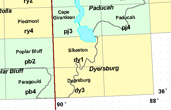
The yellow and green blocks are used to denote the boundaries of 1:250,000-scale (250K) quadrangles, and the individual rectangles mark the boundaries of 1:100,000-scale (100K) quadrangles. The names of the individual 250K quadrangles are written in a bold italic font, the 100K quadrangles are written in a smaller bold font. The 3 character code contained within each 100K quadrangle is the code used to identify files which are clipped to or contained within the boundaries of the quadrangle.
The 1 x 1 degree blocks used to name DRG files correspond to one half of a 250K quadrangle (east or west). Since the number codes used to identify DRG files are associated with 1 x 1 degree blocks, the Sikeston and Dyersburg 100K quadrangles are coded 36089 and the Poplar Bluff and Paragould quads are coded 36090 (lower right-hand corner coordinates).
Page Last Modified: April 17, 2018