Upper Midwest Environmental Sciences Center
FISHERIES LIABILITY DISCLAIMER AND FORMAT DESCRIPTION
Disclaimer
These data have been generated by State agencies under contract with the
Department of the Interior and the Upper Midwest Environmental Sciences Center
(UMESC). Although these data have been processed successfully on a computer
system at the UMESC, no warranty, expressed or implied, is made regarding the
accuracy or utility of the data on any other system or for general or
scientific purposes, nor shall the act of distribution constitute any such
warranty. Error correction is a continuing process, and UMESC corrects data
data errors routinely when a correct value can be determined. UMESC does not
delete questionable data when the correct value cannot be determined, but
attempts to mark such data with an appropriate flag. Users are strongly
cautioned to check the accuracy of any data obtained and to report suspected
values to UMESC. Methods, purposes, and conditions can vary dramatically
among data-collecting efforts and these data should not be combined with other
datasets from the UMESC or other sources unless the user fully understands the
procedures and purposes used to create each set of data and can verify that
data are comparable across sources.
-------------------------------------------------------------------------------
Crediting Language
These data are a product of the U.S. Army Corps of Engineer's Upper Mississippi
River Restoration Program (UMRR) Long Term Resource Monitoring (LTRM) element
implemented by the U.S. Geological Survey in collaboration with the five
Upper Mississippi River System (UMRS) states of Illinois, Iowa, Minnesota,
Missouri, and Wisconsin. The U.S. Army Corps of Engineers (Corps)
provides guidance and has overall program responsibility.
-------------------------------------------------------------------------------
FISH TREND ANALYSIS DATA
Annual fish monitoring on the Upper Mississippi River System (UMRS)
was implemented in 1990 under the Long Term Resource Monitoring Program
(LTRMP). Some preliminary sampling was conducted during 1989 to test
sampling methods in Pools 8, 13 and 26; however, these data are best
viewed as developmental data that are less useful for routine trend
analysis.
From 1990 through 1992, all fish sampling was conducted at subjectively
chosen permanently fixed sampling sites within each aquatic area.
Each site consisted of a pair of sampling locations separated by about
50 meters (occasionally separated by as much as 200 meters). In the
original LTRMP fish sampling design, these pairs of sampling locations
within fixed sites were considered replicates for the site and for the
aquatic area.
A statistical review of the sampling program was planned and conducted
during 1992, critically examining the original LTRMP fish monitoring
design and considering design alternatives. The final report from this
review (Gutreuter 1993) is available by request from the UMESC.
A second statistical review of the sampling program was planned and
conducted during 2001, critically examining whether sampling efficiencies
could be gained. The final report from this review
(Ickes and Burkhardt 2002) is available by request from the
Upper Midwest Environmental Sciences Center.
As a result of the 1992 statistical review of the LTRMP fish monitoring
program, major procedural changes were implemented in 1993.
The LTRMP Fisheries Component adopted a stratified random sampling design,
with aquatic areas serving as strata. Spatially randomized sites, with
proper independent replication within strata, are currently sampled.
Subjectively chosen permanently fixed sites have been retained in
tailwaters (which are too small to permit meaningful replicated random
sampling) and at a few sites of special interest (having historical
occurrences of endangered species, associated with
habitat restoration projects, etc.).
The 2001 statistical review resulted in minor procedural changes that
were implemented in 2002. Specifically, four gears were removed from the
sampling design (night electrofishing, seining, tandem fyke nets, and
tandem mini fyke nets). Thus, beginning in 2002, data associated with
these four gear types are neither available from nor collected by
the program. Please review Ickes and Burkhardt (2002) for details
regarding this change in procedure.
-------------------------------------------------------------------------------
FOREWARD
Use of LTRMP Trend Data for Fish Monitoring
The sampling design for fishes is sufficiently complex that all potential
users of these data are strongly encouraged to read and understand the Fish
Monitoring section of the LTRMP Procedures Manual (Gutreuter et al. 1995),
which describes both historical and current procedures, before undertaking
any analysis or interpretation of data. This document is accessible
by request from:
LTRM Fisheries Coordinator
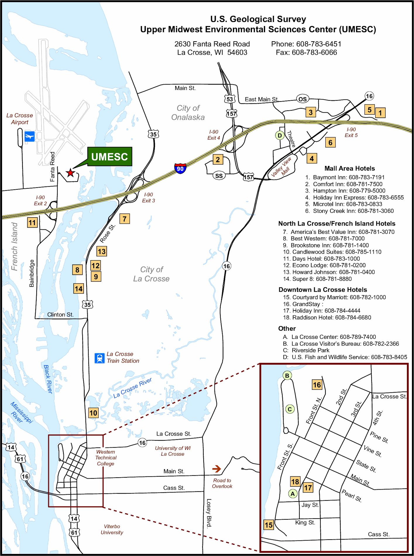
Upper Midwest Environmental Sciences Center
U.S. Geological Survey
2630 Fanta Reed Road
La Crosse, WI 54603
USA
Tel: (608) 783-7550, ext. 69
Fax: (608) 783-8058
-------------------------------------------------------------------------------
SUMMARY
LTRMP Fish Sampling Design
The LTRMP conducts annual monitoring of fishes in six study reaches of the
Upper Mississippi River System: Navigation Pools 4, 8, 13 and 26, and an
unimpounded reach near Cape Girardeau, Missouri, on the Mississippi River; and
La Grange Pool on the Illinois River. The LTRMP will continue to expand fish
monitoring beyond these six study reaches, and welcomes participation by other
agencies and groups that could sample other areas using the LTRMP sampling
protocol.
The LTRMP conducts highly standardized fish sampling in main channel border,
tailwater, side channel, contiguous (to the main channel or side channels)
backwater, and impounded aquatic areas in each study reach. Sampling is
conducted using electrofishing, hoop netting, fyke (trap) netting, seining,
and trawling.
Fish sampling is conducted from June 15 through July 31, August 1 through
September 14, and September 15 through October 31. Prior to 1993, each fixed
site was sampled once (two "replicates" per site) during each time period.
Beginning in 1993, independently distributed sampling sites have been sampled
within a combination of stratum and time period.
Gears and use of gear are highly standardized within the LTRMP. See the Fish
Monitoring section of the LTRMP Procedures Manual (Gutreuter et al. 1995) for
details.
Data Composition
Principal fish data collected are species composition, relative abundance
(catch-per-unit-effort) and length distribution of catches. Subsamples from
a few species (particularly freshwater drum) are collected for age
determination, growth analysis, and examination of food use. The LTRMP also
collects considerable site-specific data on environmental conditions and
quality assurance measures. LTRMP data and their interpretation are described
in Gutreuter et al. 1994.
-------------------------------------------------------------------------------
REFERENCES
Gutreuter, S. 1993. A statistical review of sampling of fishes in the Long
Term Resource Monitoring Program. National Biological Survey, Environmental
Management Technical Center, Onalaska, Wisconsin, December 1993. EMTC
93-T004. 15 pp.
Gutreuter, S., R. Burkhardt, and K. Lubinski. 1995. Long Term Resource
Monitoring Program Procedures: Fish Monitoring. National Biological Service,
Environmental Management Technical Center, Onalaska, Wisconsin, July 1995.
LTRMP 95-P002-1. 42 pp. + Appendixes A-J
Ieckes, B. S., and R. W. Burkhardt. 2002. Evaluation and proposed refinement
of the sampling design for the Long Term Resource Monitoring Programs fish
component. U.S. Geological Survey,
Upper Midwest Environmental Sciences Center, La Crosse, Wisconsin,
October 2002. LTRMP 2002-T001. 17 pp. + Appendixes A-E. CD-ROM included.
-------------------------------------------------------------------------------FISHERIES FIXED FORMAT FILE DOWNLOAD FILE
The fixed format file has all the data aligned to a specific column within the dataset.
Every field will start and end exactly in the same location. No field names are specified
in this format.
-------------------------------------------------------------------------------
THE "FORMAT" COLUMN CONTAINS THE FOLLOWING FORMAT SPECIFIERS:
"a": alpha character (always UPPER case);
"b": a blank space;
"blank": a missing value;
"c": alpha character/symbol/digit;
"c(xx)": character string where xx represents
the maximum number of characters allowed;
"9": any digit, 0 - 9;
"MM/DD/YYYY": date format;
-------------------------------------------------------------------------------
Field Name Short Name Format Value Range/Default Value Historical Info
--------------------------------------------------------------------------------
SITE ALIAS site a(12) 1995 TO PRESENT
BARCODE barcode 99999999 1 - 99999999 1993 TO PRESENT
FIELD STATION NUMBER fstation 9 0,1,2,3,4,5,6 1989 TO PRESENT
SITE TYPE sitetype 9 0,1,2 1993 TO PRESENT
STRATUM CLASS stratum aaa-a (See Appendix) 1989 TO PRESENT
START DATE sdate MM/DD/YYYY 05/01/1992 - To Present 1989 TO PRESENT
START TIME stime HH:MI 00:00 - 23:59 1989 TO PRESENT
FINISH DATE fdate MM/DD/YYYY 05/01/1992 - To Present 1989 TO PRESENT
FINISH TIME ftime HH:MI 00:00 - 23:59 1989 TO PRESENT
POOL/REACH pool aa (See Appendix) 1992 TO PRESENT
LOCATION CODE lcode aa999.9aaaa 1989 TO PRESENT
GEAR CODE gear aa 1989 TO PRESENT
TIME PERIOD period 9 1,2,3 1992 TO PRESENT
REPLICATE rep 99 Gear Code = "T": 1 - 99; For Gea1989 TO 1992
SUMMARY CODE summary 9.9 1,2,3 1989 TO PRESENT
PROJECT CODE project a-999 1992 TO PRESENT
EFFORT (DISTANCE) effdist 999 1 - 999 1990 TO PRESENT
EFFORT (HOURS) effhr HH 00 - 23 1989 TO PRESENT
EFFORT (MINUTES) effmin MI 00 - 59 1989 TO PRESENT
POWER GOAL pwrgoal 9999 1 - 9999 1989 TO PRESENT
POWER USED pwrused 9999 1 - 9999 1989 TO PRESENT
VOLTS volts 999 1 - 999 1989 TO PRESENT
VOLTS QF v_qf c blank,0,1,2,3,5,9 1992 TO PRESENT
AMPS amps 999.99 .01 - 999.99 1989 TO PRESENT
AMPS QF a_qf c blank,0,1,2,3,5,9 1992 TO PRESENT
PULSE RATE(HZ) pulses 999 1 - 999 1989 TO PRESENT
PULSE RATE QF p_qf c blank,0,1,2,3,5,9 1992 TO PRESENT
DUTY CYCLE dutycyc 999 1 - 999 1989 TO PRESENT
DUTY CYCLE QF dc_qf c blank,0,1,2,3,5,9 1992 TO PRESENT
UTM ZONE utmzone 99 15,16 1992 TO PRESENT
UTM EASTING utm_e 9999999 0 - 9999999 1992 TO PRESENT
UTM NORTHING utm_n 9999999 0 - 9999999 1992 TO PRESENT
GIS GRID CODE gisgrid 99999.99999 (SEE FIELD DESCRIPTIONS) 1992 TO PRESENT
ZONE 15 EASTING zone15e 9999999 0 - 9999999 1992 TO PRESENT
ZONE 15 NORTHING zone15n 9999999 0 - 9999999 1992 TO PRESENT
METHOD gpsmeth 9 1,2,3,4 1993 TO PRESENT
ACCURACY gpsacc 99.9 0 - 99.9 1992 TO PRESENT
SECCHI DISK secchi 999 -9, 0 - 999 1990 TO PRESENT
SECCHI DISK QF s_qf c blank,0,1,2,3,5,9 1992 TO PRESENT
WATER TEMP temp 99.9 0 - 99.9 1989 TO PRESENT
WATER TEMP QF t_qf c blank,0,1,2,3,5,9 1992 TO PRESENT
WATER DEPTH depth 99.9 0 - 99.9 1989 TO PRESENT
WATER DEPTH QF d_qf c blank,0,1,2,3,5,9 1992 TO PRESENT
CONDUCTIVITY cond 9999 0 - 9999 1989 TO PRESENT
CONDUCTIVITY QF c_qf c blank,0,1,2,3,5,9 1992 TO PRESENT
WATER VELOCITY current 9.99 0 - 9.99 1989 TO PRESENT
WATER VELOCITY QF cv_qf c blank,0,1,2,3,5,9 1992 TO PRESENT
DISSOLVED OXYGEN do 99.9 0 - 99.9 1995 TO PRESENT
DISSOLVED OXYGEN QF do_qf c blank,0,1,2,3,5,9 1995 TO PRESENT
STAGE HEIGHT stageht 999.9 0 - 999.9 1995 TO PRESENT
STAGE HEIGHT QF sh_qf c blank,0,1,2,3,5,9 1995 TO PRESENT
SUBMERSED AQUATIC VEGETATION (92 onsveg92 9 0,1,2,3 1992 TO 1992
DENSITY vegd 9 1,2 1992 TO PRESENT
EMERGENT AQUATIC VEGETATION (92 onleveg92 9 0,1,2,3 1992 TO 1992
EMERGENT SUB AQUATIC VEG esveg92 9 0,1,2,3 1989 TO PRESENT
PREDOMINANT SUBSTRATE substrt 9 0,1,2,3,4 1989 TO PRESENT
WOODY DEBRIS/SNAG snag 9 0,1 1992 TO PRESENT
WINGDAM/DYKE wingdyke 9 0,1 1992 TO PRESENT
TRIBUTARY MOUTH trib 9 0,1 1992 TO PRESENT
REVETMENT riprap 9 0,1 1992 TO PRESENT
INLET/OUTLET CHANNEL inout 9 0,1 1992 TO PRESENT
LOW-HEAD DAM CLOSING STRUCTURE WEIRclosing 9 0,1 1992 TO PRESENT
FLOODED TERRESTRIAL flooded 9 0,1 1992 TO PRESENT
OTHER othrstrc 9 0,1 1992 TO PRESENT
COMMENTS comment c(80) 1989 TO PRESENT
FISH LAB ID. INDICATOR labind c Y,N 1989 TO PRESENT
NO. OF CONTAINERS contanrs 99 0 - 99 1995 TO PRESENT
NO. OF FISH MEASUREMENT DATA SHEETSshtcnt 99 0 - 99 1992 TO 2002
TOTAL NUMBER FISH COLLECTED totfishc 99999 0 - 99999 1992 TO 2004
CREW LEADER CODE leader cccc 1989 TO PRESENT
PAGE NUMBER pageno 99 1 - 99 1989 TO PRESENT
RECORDING SITE rec_site 9 1,2 1992 TO PRESENT
ROW SEQUENCE NUMBER rownum 999 1 - 999 1989 TO PRESENT
SPECIES CODE fishcode accc 1989 TO PRESENT
LENGTH GRP. MIN. length 999999 1 - 999999 1989 TO PRESENT
T F S tfs a T,F,S 1990 TO PRESENT
GRP WIDTH grp_wdth 9 1,2 1989 TO PRESENT
FISH COUNT catch 999999 1 - 999999 1989 TO PRESENT
IND/AGG. WEIGHT weight 999999.99 1 - 999999.99 1989 TO PRESENT
PATHOLOGY CODE pathcode c 1989 TO PRESENT
SUBPROJECT CODE subproj cc 1989 TO PRESENT
USER DEFINED FIELDS userdef c(12) 1992 TO PRESENT
RECORDER CODE recorder cccc 1989 TO 2003
NUMBER FISH ON SHEET nfsh_cnt 99999 1993 TO 2002
ORPHAN FLAG orphflag 9 0,1 1989 TO 1992
BATCH NUMBER batchno cccc 1989 TO PRESENT
--------------------------------------------------------------------------------
Field Positions
Field Name Position
-----------------------------------------------------------------------------
SITE_ALIAS 1:12
BARCODE 13:20
FIELD_STATION_NUMBER 21:21
SITE_TYPE 22:22
HABITAT_CLASS 23:27
START_DATE_TIME 28:37
START_TIME 38:42
FINISH_DATE_TIME 43:52
FINISH_TIME 53:57
POOL_REACH 58:59
LOCATION_CODE 60:70
GEAR_CODE 71:72
SAMPLING_TIME_PERIOD 73:73
REPLICATE 74:75
SUMMARY_CODE 76:78
PROJECT_CODE 79:83
EFFORT_DISTANCE 84:86
EFFORT_HOURS 87:88
EFFORT_MINUTES 89:90
POWER_GOAL 91:94
POWER_USED 95:98
VOLTS 99:102
VOLTS_QF 103:103
AMPS 104:110
AMPS_QF 111:111
PULSE_RATE 112:117
PULSE_RATE_QF 118:118
DUTY_CYCLE 119:121
DUTY_CYCLE_QF 122:122
UTM_ZONE 123:124
COORDINATE_EAST_WEST 125:131
COORDINATE_NORTH_SOUTH 132:138
GIS_GRID_CODE 139:149
ZONE15_EAST_WEST 150:156
ZONE15_NORTH_SOUTH 157:163
METHOD 164:164
ACCURACY 165:169
SECCHI_DISK 170:172
SECCHI_DISK_QF 173:173
WATER_TEMP 174:177
WATER_TEMP_QF 178:178
WATER_DEPTH 179:183
WATER_DEPTH_QF 184:184
SPECIFIC_CONDUCTIVITY 185:188
SPECIFIC_CONDUCTIVITY_QF 189:189
WATER_VEL 190:193
WATER_VEL_QF 194:194
DISSOLVED_OXYGEN 195:198
DISSOLVED_OXYGEN_QF 199:199
STAGE_HEIGHT 200:204
STAGE_HEIGHT_QF 205:205
SUBMERSED_AQUATIC_VEG_92 206:206
DENSITY_EMERGENT_SUBMERSED_VEG 207:207
EMERGENT_AQUATIC_VEG_92 208:208
EMERGENT_SUBMERSED_AQUATIC_VEG 209:209
SUBSTRATE_CODE 210:210
SUBSTRING(STRUCTURES,1,1) 211:211
SUBSTRING(STRUCTURES,2,1) 212:212
SUBSTRING(STRUCTURES,3,1) 213:213
SUBSTRING(STRUCTURES,4,1) 214:214
SUBSTRING(STRUCTURES,5,1) 215:215
SUBSTRING(STRUCTURES,6,1) 216:216
SUBSTRING(STRUCTURES,7,1) 217:217
SUBSTRING(STRUCTURES,8,1) 218:218
SITE_COMMENT 219:298
LAB_ID_FISH 299:299
NO_CONTAINERS 300:301
FISH_MEASURE_SHEET_COUNT 302:303
TOTAL_FISH_COLLECTED 304:309
CREW_LEADER_CODE 310:313
PAGE_NUMBER 314:315
RECORDING_SITE 316:316
ROW_SEQUENCE_NUMBER 317:319
SPECIES_CODE 320:323
LENGTH_GROUP_MIN 324:329
TOTAL_FORK_STANDARD_LENGTH 330:330
GROUP_WIDTH 331:331
FISH_COUNT 332:337
INDIV_AGGREG_WEIGHT 338:348
SUBSTRING(USER_DEFINED_FIELDS,1,1) 349:349
SUBSTRING(USER_DEFINED_FIELDS,2,2) 350:351
SUBSTRING(USER_DEFINED_FIELDS,4,12)352:363
RECORDER_CODE 364:367
NUMBER_FISH_ON_SHEET 368:372
'0' 373:373
SBATCH 374:377
--------------------------------------------------------------------------------
Field Descriptions
SITE ALIAS
Used to record an optional site alias for field station use.
BARCODE
Identifying barcode for fish data sheets
FIELD STATION NUMBER
Numeric code identifying the field station number. Listed below are the
valid codes and their corresponding field station.
1 = Lake City, MN 4 = Brighton, IL
2 = Onalaska, WI 5 = Jackson, MO
3 = Bellevue, IA 6 = Havana, IL
SITE TYPE
Numeric code identifying the type of sampling site, as follows:
0 = Primary randomly selected sampling site
1 = Alternate randomly selected sampling site
2 = Subjectively chosen permanently fixed site
STRATUM CLASS
Alphabetic code identifying sampling stratum class, as follows:
BWC-O = Backwater, offshore
BWC-S = Backwater, shoreline
MCB-U = Main channel border, unstructured
MCB-W = Main channel border, wing dam
IMP-O = Impounded, offshore
IMP-S = Impounded, shoreline
SCB = Side channel border
TWZ = Tailwater zone (permanently fixed sampling sites)
CTR = Main channel trough (optional sampling only)
UXO = Unexploded Ordinance Area - Pool 13
START DATE
Date on which a gear collection was initiated (e.g., the date on which
a net was set).
Ten-digit numeric mm/dd/yyyy format, example April 1, 1995, is represented as
04/01/1995.
START TIME
2400-h (military) Central Standard Time (CST) at which a gear sample begins
(e.g., the time a net was set or an electrofishing run was begun).
FINISH DATE
Date on which a gear collection was completed (e.g., the date on which a
net was pulled up).
Ten-digit numeric mm/dd/yyyy format, example April 1, 1995, is represented as
04/01/1995.
FINISH TIME
2400-h (military) Central Standard Time (CST) at which a gear sample ends
(e.g., the time a net was pulled or an electrofishing run was stopped).
POOL/REACH
Alphanumeric code for the LTRMP study reach or pool number:
04 = Pool 4, UMR 26 = Pool 26, UMR
08 = Pool 8, UMR LG = La Grange Pool, Illinois River
13 = Pool 13, UMR OR = Open Mississippi River
LOCATION CODE
Alphanumeric code for LTRMP Location Code having the format nnnnn.nnnnn. For
randomly selected sites enter nnnn.RS, where nnnn is the site number from the
sampling map or site list. For permanently fixed sites record rmmm.ma, where
r designates the river (M = Mississippi and I = Illinois), mmm.m is the river
mile (recorded to the nearest 0.1 mile), and a is an alphabetic code for the
relative lateral position across the floodplain.
GEAR CODE
Alphabetic gear code (collection method) summarized below:
D = Day (1 h after sunrise to 1 h before sunset) electrofishing
F = Fyke netting
GR = Gill netting, perpendicular (to shore) set
GL = Gill netting, parallel (to shore) set
HS = Hoop netting, small LTRMP net
HL = Hoop netting, large LTRMP net
M = Mini fyke netting
N = Night (1 h after sunset to 1 h before sunrise) electrofishing
S = Seining
T = Trawling
TP = Plankton trawling
X = Tandem fyke netting
Y = Tandem mini fyke netting
TA = Trammel netting, anchored set
TD = Trammel netting, floating and drifting
TIME PERIOD
Numeric LTRMP Sampling Time Period code. Example: The first sampling time
period is coded as 1.
REPLICATE
Code for pseudo-replicated gear deployments at fixed collection sites.
SUMMARY CODE
Numeric code documenting the overall quality of a sample collection as
described below:
1 = Gear failure; site may be re-sampled within time period
2 = Site cannot be sampled (i.e., site is dry or inaccessible)
2.9 = Electrofishing site sampled with single dip net due to reduced crew size
3 = Sample collected under unusual environmental conditions
4 = Weighing equipment may be in error due to wind and waves
5 = Normally completed sample; all LTRMP procedures followed
6 = Non-critical gear modification (e.g., fyke net lead shortened)
7 = Pseudo-shoreline used for shoreline gear
8 = Minor gear damage or noncritical gear failure
PROJECT CODE
Alphanumeric LTRMP project code. Format is A-nnn, where A is a letter
describing project type and nnn is a special project number. Project types
are as follows:
M = RTA standardized resource monitoring
B = HREP biological response monitoring
E = Ad hoc exploratory sampling
R = Special research project
EFFORT (DISTANCE)
Numeric field for recording the length (in meters) of an electrofishing run or
trawl haul. Completion of this field is required only for electrofishing,
trawling, and trammel net drifting
EFFORT HOURS
Used to document actual elapsed time in hours required to capture a
sample of fish (actual duration of gear deployment).
This field should be blank for seine samples.
EFFORT MINUTES
Used to document actual elapsed time in minutes required to capture a
sample of fish (actual duration of gear deployment).
This field should be blank for seine samples.
POWER GOAL
Field to record the predetermined electrofishing power goal (in watts).
Note: For electrofishing only.
POWER USED
Field to record the actual average electrofishing power (in watts) consumption.
VOLTS
Field to record DC volts.
VOLTS QF
The Quality Factor (QF) is a one-digit
numeric field as follows:
Blank = Normal operation/acceptable measurement
0 = Voltage meter inoperative
1 = Unstable voltage readings (varies by >70 V); equipment questionable
AMPS
Numeric field to record DC current (in amperes).
AMPS QF
The Quality Factor (QF) is
a one-digit numeric field as follows:
Blank = Normal operation/acceptable current determination
0 = Ammeter inoperative
1 = Unstable current readings (varies by >10 amps)
PULSE (Hz)
Numeric field to record pulse frequency (Hertz [=cycles/sec]).
PULSE QF
Quality Factor for PULSE.
DUTY CYCLE
Numeric field to record electrofishing duty cycle (percentage of
time current is flowing).
DUTY CYCLE QF
Quality Factor for DUTY CYCLE.
UTM ZONE
Numeric field to record Global Positioning System (GPS) zone. LTRMP data
resides in either zone 15 or 16.
UTM EASTING
Easting coordinate Universal Transverse Mercator (UTM) for a water quality
sampling site (in meters). Proper interpretation of this coordinate requires
reference to the appropriate UTM zone (15 or 16 for LTRMP). This is the
initially assigned and registered UTM easting for an LTRMP sampling site.
UTM NORTHING
Northing coordinate Universal Transverse Mercator (UTM) for a water quality
sampling site (in meters). Proper interpretation of this coordinate requires
reference to the appropriate UTM zone (15 or 16 for LTRMP). This is the
initially assigned and registered UTM northing for an LTRMP sampling site.
GIS GRID CODE
Modified and concatenated utm coordinate pair used to generalize site
locations within a 50 square meter area.
ZONE 15 EASTING
Zone 15 easting coordinate Universal Transverse Mercator (UTM) for a water
quality sampling site (in meters) referenced to a single UTM zone (15).
This value is calculated from UTM Easting and is particularly useful for
LTRMP areas that include both UTM zone 15 and UTM zone 16.
ZONE 15 NORTHING
Zone 15 northing coordinate Universal Transverse Mercator (UTM) for a water
quality sampling site (in meters) referenced to a single UTM zone (15).
This value is calculated from UTM Northing and is particularly useful for
LTRMP areas that include both UTM zone 15 and UTM zone 16.
METHOD
Numeric code specifying the method used to locate the collection site,
as follows:
1 = UTMs recorded from cross-reference between base map and site features
2 = UTMs recorded from GPS device (Magellan)
3 = Latitude (N/S coordinates; degrees, minutes, seconds) and
longitude (E/W coordinates; degrees, minutes,
seconds) recorded from GPS (Loran)
4 = Latitude and longitude recorded from cross-reference between base map
and site features
ACCURACY
Numeric field to record a measure of positioning accuracy. Record Percent
Dilution of Precision (PDOP) from GPS devices and the following codes for base
map cross-reference and revisits to marked fixed sites:000.1 = Almost certain accuracy within 100 m because of immediate proximity to
uniquely identifiable features (undisturbed marker, wing dam, day mark,
etc.).
000.2 = High confidence of accuracy within 100 m because of agreement between
general site appearance and identifiable features on a base map.
000.3 = Other than above.
SECCHI DISK
Numeric field for recording measurement of water transparency (in centimeters)
using a Secchi disk.
SECCHI DISK QF
Quality Factor (QF) codes are as follows:
Blank = Normal measurement/no problems
0 = Equipment inoperative
1 = Equipment in question (i.e., paint discolored)
4 = Used proximate measurement - no measurement at this site
3 = Reading off scale (high)
5 = No sample taken
9 = Non-standard method used
WATER TEMP
Numeric field to record water temperature measurement to the nearest 0.1
Centigrade degree.
WATER TEMP QF
Quality Factor (QF) codes are as follows:
Blank = Normal measurement/no problems
0 = Equipment inoperative
1 = Equipment in question
4 = Used proximate measurement - no measurement at this site
5 = No reading taken
9 = Non-standard method used
WATER DEPTH
Numeric field to record water depth to the nearest 0.1 meter.
WATER DEPTH QF
Quality Factor (QF) codes are as follows:
Blank = Normal measurement/no problems
0 = Equipment inoperative
1 = Equipment in question
5 = No sample taken
9 = Non-standard method used
CONDUCTIVITY
Numeric field to record conductivity to the nearest 1 S/cm.
CONDUCTIVITY QF
Quality Factor (QF) codes are as follows:
Blank = Normal measurement/no problems
0 = Equipment inoperative
1 = Equipment in question
3 = Reading off scale (high)
4 = Used proximate measurement - no measurement at this site
5 = No sample taken
9 = Non-standard method used
WATER VELOCITY
Numeric field to record water velocity to the nearest 0.1 meter/second.
WATER VELOCITY QF
Quality Factor (QF) codes are as follows:
Blank = Normal measurement/no problems
0 = Equipment inoperative
1 = Equipment in question
3 = Reading off scale (high)
5 = No sample taken
9 = Non-standard method used
DISSOLVED OXYGEN
Numeric field to record dissolved oxygen concentration to the nearest 0.1 mg/l.
DISSOLVED OXYGEN QF
Quality Factor (QF) codes are as follows:
Blank = Normal measurement/no problems
0 = Equipment inoperative
1 = Equipment in question
3 = Reading off scale (high)
4 = Used proximate measurement - no measurement at this site
5 = No sample taken
9 = Non-standard method used
STAGE HEIGHT
Water elevation measurement obtained from local stage height gauge.
STAGE HEIGHT QF
Quality Factor codes are as follows:
1 = Feet relative (local) measure
2 = Feet above mean sea level (AMSL)
3 = Meters relative (local) measure
4 = Meters above mean sea level (AMSL)
SUBMERSED AQUATIC VEGETATION (1992 Only)
Numeric field to record qualitative estimate of percent of area within a
100 meter radius in which there is submersed aquatic vegetation, based
on visual observation. Values are as follows:
0 = 0% (no submersed aquatic vegetation apparent)
1 = 1%-19% coverage
2 = 20%-49% coverage
3 = 50% and over coverage
DENSITY
Numeric field to record qualitative estimate of density of both emergent and
submersed aquatic vegetation within a 100-m radius, based on visual observation.
Values are as follows:
1 = Prevailing vegetation is sparse (probably less than 10 stems per square
meter) and does not create an "edge" at its perimeter.
2 = Prevailing vegetation is dense (probably greater than or equal to 10 stems
per square meter) and creates a distinct "edge" at its perimeter.
EMERGENT AQUATIC VEGETATION (1992 Only)
Numeric field to record qualitative estimate of percent of area within a
100 meter radius in which there is emergent aquatic vegetation, based on visual
observation.
Values are as follows:
0 = 0% (no emergent aquatic vegetation apparent)
1 = 1%-19% coverage
2 = 20%-49% coverage
3 = 50% and over coverage
EMERGENT SUB AQUATIC VEG
Numeric field to record qualitative estimate of percent of area within a
100 meter radius in which there is emergent and/or submersed aquatic vegetation,
based on visual observation.
Values are as follows:
0 = 0% (no emergent/submersed aquatic vegetation apparent)
1 = 1%-19% coverage
2 = 20%-49% coverage
3 = 50% and over coverage
PREDOMINANT SUBSTRATE
Numeric field to record qualitative observation of sediments based on
visual and tactile observation. Values are as follows:
1 = Silt (very fine and very soft sediments that may contain highly hydrated
[very soft] clay; sand lacking)
2 = Silt/Clay/Little Sand (fine and soft sediments dominated by silt but
usually containing little fine sand, with perhaps dehydrated [firm] clay
pellets or moderately hydrated clay with little fine sand)
3 = Sand/Mostly Sand (firm to very firm, fine to coarse sediments with sand
dominant, or entirely sand)
4 = Gravel/Rock/Hard Clay (hard substrate consisting of dehydrated [firm]
clay, gravel, rock, bedrock, or concrete)
WOODY DEBRIS/SNAG
An indicator to record the presence of other habitat structure within a 100
meter radius.
WINGDAM/DYKE
An indicator to record the presence of other habitat structure within a 100
meter radius.
TRIBUTARY MOUTH
An indicator to record the presence of other habitat structure within a 100
meter radius.
REVETMENT
An indicator to record the presence of other habitat structure within a 100
meter radius.
INLET/OUTLET CHANNEL
An indicator to record the presence of other habitat structure within a 100
meter radius.
LOW-HEAD DAM CLOSING STRUCTURE WEIR
An indicator to record the presence of other habitat structure within a 100
meter radius.
FLOODED TERRESTRIAL
An indicator to record the presence of other habitat structure within a 100
meter radius.
OTHER
An indicator to record the presence of other habitat structure within a 100
meter radius.
COMMENTS
Eighty-character field to record miscellaneous comments and observations.
FISH LAB ID. INDICATOR
An indicator if some fish were taken back to lab for identification
rather than in the field.
# OF CONTAINERS
Numeric field to record the number of individual containers (whirl-pacs,
vials, etc.) containing specimens that were returned to the field
station or lab for identification or measurement.
# OF FISH MEASUREMENT DATA SHEETS
Numeric field to record the total number of Fish Measurement Sheets
(recorded in the field and lab) completed for the sample collection.
TOTAL NUMBER FISH COLLECTED
Numeric field to record the total number of fish (of all species, whether
enumerated in the field or lab) captured in the sample collection.
This number is obtained from a manual tally of fish counts on the
corresponding Fish Measurement Sheets.
CREW LEADER CODE
Alphanumeric field to identify the LTRMP Crew Leader responsible for
recording of this collection sheet data. These codes are permanently
assigned to LTRMP staff at each station.
PAGE NUMBER
Numeric field to record the page number of the Fish Measurement Sheet.
RECORDING SITE
Numeric field to record the site at which fish on a
particular Fish Measurement Sheet were identified, enumerated,
and measured. Valid codes are as follows:
1 = Fish Measurement Sheets completed in the field.
2 = Fish Measurement Sheets completed in the lab or office.
ROW SEQUENCE NUMBER
Numeric field to identify, isolate, and sort individual fish detail records.
SPECIES CODE
Alphabetic field to identify the fish species for a particular record of data.
Following are the valid codes and the common species name for which they
represent:
ABLP = American brook lamprey
AMEL = American eel
BCWC = Black crappie x white crappie hybrid
BDDR = Banded darter
BDSN = Bleeding shiner
BECB = Bigeye chub
BESN = Bigeye shiner
BGLE = Bluegill x longear sunfish hybrid
BGOS = Bluegill x orangespotted sunfish hybrid
BGRS = Bluegill x redear sunfish hybrid
BGWM = Bluegill x warmouth hybrid
BHCP = Bighead carp
BHMW = Bullhead minnow
BKBF = Black buffalo
BKBH = Black bullhead
BKCP = Black crappie
BKSB = Brook stickleback
BKSS = Brook silverside
BLCF = Blue catfish
BLGL = Bluegill
BMBF = Bigmouth buffalo
BMSN = Bigmouth shiner
BNBH = Brown bullhead
BNDC = Blacknose dace
BNDR = Bluntnose darter
BNMW = Bluntnose minnow
BNTT = Brown trout
BPTM = Blackspotted topminnow
BRBT = Burbot
BSDR = Blackside darter
BSMW = Brassy minnow
BTSN = Blacktail shiner
BTTM = Blackstripe topminnow
BUSK = Blue sucker
BWFN = Bowfin
CARP = Common carp
CCGF = Carp x goldfish hybrid
CKCB = Creek chub
CKCS = Creek chubsucker
CLDR = Crystal darter
CLSR = Central stoneroller
CMMW = Central mudminnow
CMSN = Common shiner
CNCF = Channel catfish
CNLP = Chestnut lamprey
CNSN = Channel shiner
DYDR = Dusky darter
ERSN = Emerald shiner
FHCF = Flathead catfish
FHMW = Fathead minnow
FKMT = Freckled madtom
FLER = Flier
FTDR = Fantail darter
FWDM = Freshwater drum
GDEY = Goldeye
GDFH = Goldfish
GDRH = Golden redhorse
GDSN = Golden shiner
GNSF = Green sunfish
GSBG = Green sunfish x bluegill hybrid
GSCP = Grass carp
GSDR = Greenside darter
GSOS = Green sunfish x orangespotted sunfish hybrid
GSPK = Grass pickerel
GSPS = Green sunfish x pumpkinseed hybrid
GSRS = Green sunfish x redear hybrid
GSWM = Green sunfish x warmouth hybrid
GTSN = Ghost shiner
GZSD = Gizzard shad
HFCS = Highfin carpsucker
HHCB = Hornyhead chub
IDSS = Inland silverside
IODR = Iowa darter
JYDR = Johnny darter
LBLP = Least brook lamprey
LESF = Longear sunfish
LGPH = Logperch
LKSG = Lake sturgeon
LMBS = Largemouth bass
LNGR = Longnose gar
LNST = Longnose gar x spotted gar hybrid
LSSR = Largescale stoneroller
MDDR = Mud darter
MGNP = Tiger muskellunge
MMSN = Mimic shiner
MNEY = Mooneye
MQTF = Western mosquitofish
MSKG = Muskellunge
NFSH = No fish caught
NHSK = Northern hog sucker
NTPK = Northern pike
NTSF = Northern studfish
OSLE = Orangespotted sunfish x longear hybrid
OSSF = Orangespotted sunfish
OTDR = Orangethroat darter
OZMW = Ozark minnow
PDFH = Paddlefish
PDSN = Pallid shiner
PGMW = Pugnose minnow
PNMW = Plains minnow
PNSD = Pumpkinseed
PRPH = Pirate perch
PSBG = Pumpkinseed x bluegill hybrid
PSOS = Pumpkinseed x orangespotted sunfish hybrid
PSWM = Pumpkinseed x warmouth hybrid
QLBK = Quillback
RBST = Rainbow smelt
RDSN = Red shiner
RESF = Redear sunfish
RKBS = Rock bass
RRDR = River darter
RSSF = Redspotted sunfish
RUDD = Rudd
RVCB = River chub
RVCS = River carpsucker
RVRH = River redhorse
RVSN = River shiner
SBSN = Silverband shiner
SBWB = Striped bass x white bass hybrid
SCBS = Silver Carp Big Head Carp Hybrid
SDBS = Striped bass
SFCB = Sicklefin chub
SFSN = Spotfin shiner
SGCB = Sturgeon chub
SGER = Sauger
SGWE = Sauger x walleye hybrid
SHDR = Slenderhead darter
SHRH = Shorthead redhorse
SHTM = Starhead topminnow
SJHR = Skipjack herring
SKCB = Speckled chub
SLDR = Slough darter
SMBF = Smallmouth buffalo
SMBS = Smallmouth bass
SMMW = Suckermouth minnow
SNGR = Shortnose gar
SNPD = Shovelnose sturgeon x pallid sturgeon hybrid
SNSG = Shovelnose sturgeon
SNSN = Sand shiner
SPMT = Striped mullet
SPSK = Spotted sucker
SPSN = Striped shiner
SRBD = Southern redbelly dace
STBS = Spotted bass
STCT = Stonecat
STGR = Spotted gar
STSN = Spottail shiner
SVCB = Silver chub
SVCP = Silver carp
SVLP = Silver lamprey
SVMW = Mississippi silvery minnow
SVRH = Silver redhorse
TFSD = Threadfin shad
TPMT = Tadpole madtom
TTPH = Trout perch
U-CL = Unidentified Clupeidae (shads)
U-CN = Unidentified Centrarchidae (sunfishes)
U-CT = Unidentified Catostomidae (suckers)
U-CY = Unidentified Cyprinidae (minnows)
U-HI = Unidentified Hiodontidae (mooneyes)
U-IL = Unidentified catfish (catfishes)
U-LY = Unidentified Petromyzontidae (lampreys)
UNID = Unidentified
U-PC = Unidentified Percidae (perches)
U-SG = Unidentified Acipenseridae (sturgeons)
WDSN = Weed shiner
WLYE = Walleye
WPYB = White perch x yellow bass hybrid
WRMH = Warmouth
WSDR = Western sand darter
WSMW = Western silvery minnow
WSSN = Wedgespot shiner
WTBS = White bass
WTCP = White crappie
WTPH = White perch
WTSK = White sucker
YLBH = Yellow bullhead
YOYF = Age-0 fish
YWBS = Yellow bass
YWPH = Yellow perch
LENGTH
Numeric field to identify the lower bound of the length group to which a fish
record belongs (measured in millimeters). A length group is defined as all
fish of a particular species for a collection which fall within the GRP WIDTH
(group width) range. See the GRP WIDTH description.
T F S
Alphabetic code to identify system used for length measurement:
Following are valid codes:
T or Blank = Maximum total length measurement; distance from anterior-most
extreme of head (jaw closed) to most distant lobe of caudal fin (lobes
compressed to achieve maximum length)
F = Fork length; distance from anterior-most extreme of head (jaw closed) to
fork of caudal fin (tip of median fin rays)
S = Standard length; distance from anterior-most extreme of head (jaw
closed) to caudal peduncle (posterior margin of hypural bone)
GROUP WIDTH
Numeric field to record the range in centimeters of a
a length group from within which fish were enumerated or bulk-
weighed. For example, if LENGTH is 40 and GRP WIDTH is 1, then
the range of lengths for the fish representing this fish record would be
from 40 through 49 millimeters.
This field should be blank for fish that are unmeasured or individually
measured to the nearest 1 millimeter.
FISH COUNT
Numeric field to record counts of fish represented by
the row of data. Fish Count is 1 for all individually measured
lengths and weights and ÷1 for bulk counts. For example, if a
particular fish was measured to the nearest 1 millimeter, then Fish
Count is 1. If just one fish of a particular length group is
encountered during length group enumeration, then Fish Count is
also 1 for that length group. However, if 10 fish of a length
group are encountered during group enumeration, then Fish
Count is 10.
IND/AGG. WEIGHT
Numeric field to record individual or aggregate weights
(in grams). Aggregate weights are distinguished by the presence
of a Group Width value. Weights are measured only for special purposes.
PATHOLOGY CODE
Special information not routinely collected during standardized
monitoring activities.
Represents LTRMP fish health/pathogen codes as follows:
0 or blank = No visible abnormality
1 = Parasite
2 = Skeletal abnormality
3 = Tumors
4 = Injury
5 = Skin/fin/eye
6 = Other
SUBPROJECT CODE
Two byte length alphanumeric field containing special information
not routinely collected during standardized monitoring activities.
Represents data needed to interpret data in the USER DEFINED FIELDS
as follows:
Following is a description of what these two bytes represent.
Byte 1:
1 = Aging structures (otoliths, scales, etc.) collected, specimen bar code
2 = Stomach contents collected
3 = Both aging structures and stomach contents collected
0 = Continued from previous line
Note: When the above codes are used, the specimen bar
code number should be recorded in the USER DEFINED FIELDS.
Byte 2:
0 = Tag implanted, number follows in bytes 4-14, fish released
1 = Tag recovered, number follows in bytes 4-14, fish released
2 = Tag recovered, number follows in bytes 4-14, fish not released
3 = Tag scar visible, fish released
4 = Tag scar visible, fish not released
5 = Fin clipped, fin position follows in byte 14
6 = Fin clip recovered, position follows byte 14, released
7 = Fin clip recovered, position follows in byte 14, not released
USER DEFINED FIELDS
Twelve byte length alphanumeric field containing special information
not routinely collected during standardized monitoring activities.
Following is a description of what these twelve bytes represent.
Bytes 1-10: Specimen number (aging structure and/or stomach contents).
Byte 11: Fin clipping position.
-- or --
Bytes 1-11: Tag number.
Byte 12: Gill net mesh size code as follows:
1 = 4"
2 = 6"
3 = 8"
4 = 10"
-- or --
Byte 12: Number of seines or trawls
RECORDER CODE
Alphanumeric field to identify the LTRMP recorder responsible for recording of
this measurement sheet data. These codes are permanently assigned to LTRMP
staff at each station.
NUMBER OF FISH ON SHEET
Numeric field to record the total number of fish (sum of Fish Counts) recorded
on this Fish Measurement Sheet.
ORPHAN FLAG
Administrative field used to track orphan fish records.
Orphan records should no longer occur due to barcode usage.
BATCH NUMBER
Administrative field used to track keyed data batches.

![]() U.S. Department of the Interior |
U.S. Geological Survey
U.S. Department of the Interior |
U.S. Geological Survey
Page Contact Information: Contacting the Upper Midwest Environmental Sciences Center
