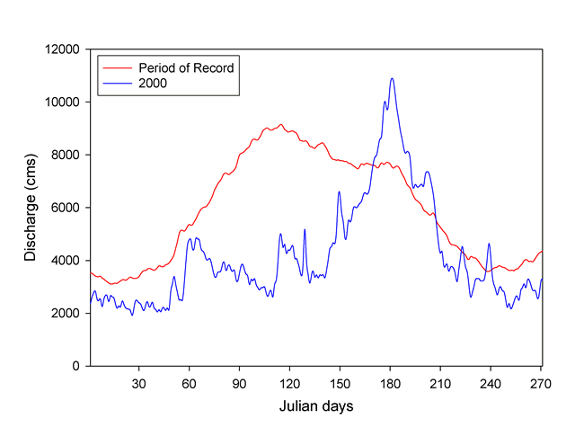
USGS - science for a changing world

Upper Midwest Environmental Sciences Center

Home/ Overview/ Science Programs/ Data Library/ Products and Publications/States/ Rivers/Teachers and Students/ Links/ Contact/ Search
folder.gifSummary of Monitoring Findings for Fiscal Year 2000
  Figures

Figure 2. Average daily discharge of the Mississippi River at St. Louis for the period of record (68 years, red line) and for the first 9 months of 2000 (blue line). Similar patterns were evident at St. Paul, Minnesota; Keokuk, Iowa; and on the Illinois River at Kingston Mines, Illinois.
Mean discharge (m3/sec x 1,000) at the St. Louis gaging station, Upper Mississippi River System, 2002.

Accessibility FOIA Privacy Policies and Notices

Take Pride in America logo USA.gov logo U.S. Department of the Interior | U.S. Geological Survey
URL: http://www.umesc.usgs.gov/reports_publications/ltrmp/2000/summary_findings/figure02.html
Page Contact Information: Contacting the Upper Midwest Environmental Sciences Center
Page Last Modified: October 2, 2007