Upper Midwest Environmental Sciences Center
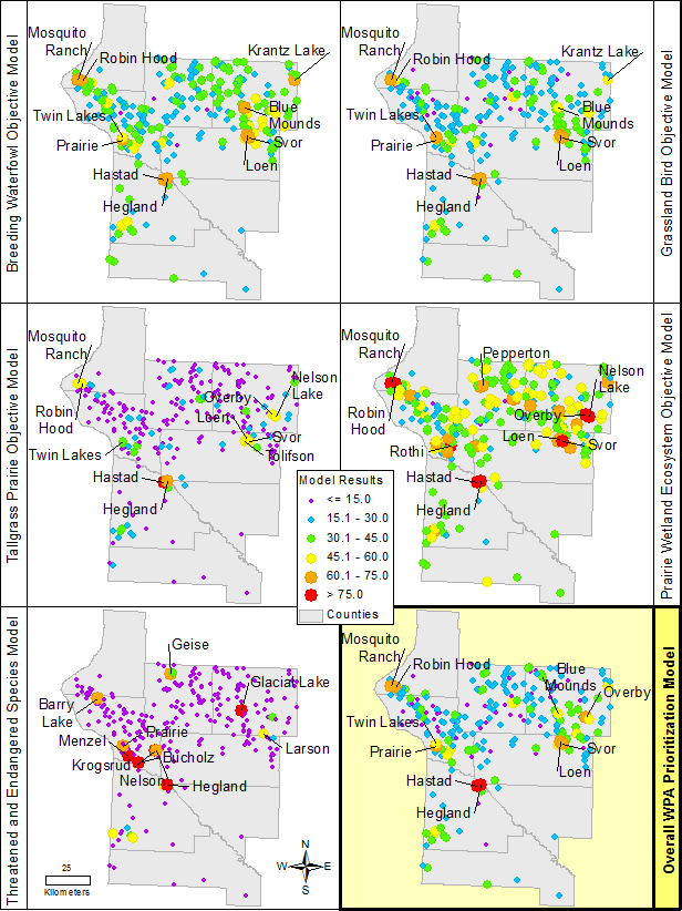
A Tool for Prioritizing Management Units at Morris Wetland Management DistrictJason Rohweder1, Sara Vacek2 and Dr. Wayne E. Thogmartin1 IntroductionWhere are most important places to direct conservation effort? Such a simple question is not answered simply. There are a myriad of priorities, constraints, and capacities, both scientific and socio-economic, which in combination guide the allocation of management effort. An honest accounting of these priorities, constraints, and capacities is essential for efficient, effective action. Morris Wetland Management District (WMD), a land management office of the United States Fish and Wildlife Service, was established in 1964 to preserve and protect habitat critical to waterfowl and other prairie wildlife. Morris WMD manages 245 separate parcels of federally owned land called Waterfowl Production Areas (WPA) within an eight county district (Big Stone, Lac Qui Parle, Pope, Stevens, Swift, Traverse, Yellow Medicine and Chippewa). Together, the 245 WPAs encompass over 50,000 acres of land dedicated to wildlife and wildlife dependent public recreation. Morris WMD also oversees over 26,000 acres of privately owned wetlands and grasslands that, while remaining privately owned, are protected by permanent conservation easements. Morris WMD will soon complete its Habitat Management Plan (HMP), which clearly identifies priority resources for the district. The HMP guides management by describing habitat objectives and management strategies that will best support those priority resources. However, while Morris WMD is charged with managing a myriad of natural resources over a large geographic area, it does not possess sufficient resources to manage every unit to its full potential. The issue of where to manage given limited resources is the biggest concern Morris WMD faces in implementing the HMP. We have developed a decision support tool that will help Morris WMD make thoughtful and strategic choices about where to spend its limited management resources. It incorporates landscape and management unit features to identify which WPAs have the greatest biological potential with respect to priority resources and habitats. The district can use this information to prioritize and target management, which will help with development of annual habitat plans. MethodsGIS data layers were assembled, reclassified, and used as input layers within models developed to rank WPAs for each of five station objectives (breeding waterfowl, grassland birds, tallgrass prairie, prairie wetlands, and threatened and endangered species). A single overall prioritization model was also built, which combined the results of the five input models. The criteria and associated weights for each model were identified at the December 2009 workshop and in subsequent discussions with Morris WMD staff. The models were built using a system of weighted overlays. The input data layers (i.e., prioritization criteria) were overlaid and the scores for a particular location were averaged using designated model influence percentages (weights) as a modifier. Higher weights were given to those data layers that were considered higher priority. ResultsMaps depicting the relative scores of each waterfowl production area (WPA) for each objective model and also the overall WPA prioritization model. The top ten highest ranked WPAs are labeled in each panel.
Expanded tabular results of the analyses are available in a sortable format. Download Morris WMD Prioritization Products
Science ImpactThe development of this decision support tool gives USFWS resource managers the ability to make thoughtful and strategic choices about where to spend its limited management resources. This tool makes the processes used to prioritize these management units more transparent, improving the defensibility of management decisions.This project was completed in 2011. Please direct problems downloading files to Jason Rohweder. |
|||||||||
Page Contact Information: Contacting the Upper Midwest Environmental Sciences Center
Page Last Modified: May 21, 2014


