

Upper Midwest Environmental Sciences Center
Maps, Models, and Tools for Bird Conservation Planning LINK: ArcGIS Tools for Conservation Planning
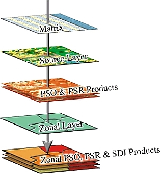
LINK’s main purpose is to make comparisons of conservation potential between management units and the surrounding landscape. LINK does this by summarizing potential species richness, habitat diversity, and habitat composition. There are three main data sources needed to run a LINK Query. These data sources include matrices, source layers, and zonal layers (Figure 1). LINK relates values contained in a matrix to a raster data layer, called a source layer, to generate indices of potential habitat. The program summarizes indices of potential
The source layer is a raster spatial data layer that contains landscape information for the species listed in the matrix. The source layer must be an integer ESRI Grid (e.g. National Land Cover Dataset). A zonal layer is an ESRI Shapefile used to divide the landscape into units of comparison. Counties within a state or management units within a refuge are examples of zonal layers.
Download LINK (371 MB, February 23, 2010) LINK is currently available for ArcGIS 9.3. Download LINK- PowerPoint (25 MB) Impact of UMESC ScienceLINK allows for regional analysis of habitat suitability, habitat diversity, and species abundance. This is an explorative tool to be utilized by land managers to strategize conservation effort. For additional information, contact Tim Fox |
 LINK is a set of Environmental Systems Research Institute (ESRI) ArcGIS tools designed to analyze habitat patterns across a landscape. LINK is the latest product from a series of
 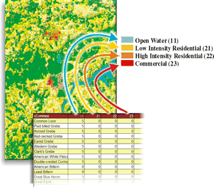 The matrix related to the source layer has habitat suitability scores ranging from 0 (little to no value as habitat) to 100(prime habitat). For each cover type within the source layer there is a corresponding column within the matrix (Figure 2). The Relationship Manager allows the user to create an association between matrices and source layers, and between source layers and zonal layers.
Page Contact Information: Contacting the Upper Midwest Environmental Sciences Center
Page Last Modified: July 10, 2014