Acadia National Park Landscape Scale Conservation and Easement Planning
Acadia National Park (ANP) consists of a widely dispersed set of parcels
in and adjacent to the Gulf of Maine. Park lands are found on Mt. Desert
Island, the Schoodic Peninsula, and offshore islands in Knox and Hancock
County, Maine and are interspersed by private and other public lands.
Because of the interspersion of private landholdings with Park property
and the potential for increased development, the Park faces major challenges
in the preservation and protection of its biological and ecological resources.
Development on lands adjacent to the Park continues to intensify and an
offshore aquaculture industry and water quality issues have raised concerns
about the impacts on the Park's natural resources. Many of these adjacent
non-Park parcels and islands are critically important to the integrity
of wildlife populations, ecosystem health, and other natural resources
within Park boundaries.
The Park has a legislatively authorized conservation easement program
that has been used to provide additional protection to critically important
private lands (Section 102 (h) of PL 99-420). The 1986 Acadia Park Boundary
legislation outlined Acadia NP authority, responsibilities, and guidelines
for developing conservation easements. However, the Park has only used
broad and general criteria for evaluating conservation easements on adjacent
land. These criteria included: the benefit for resource protection and
proximity of the easement to the Boundary of the Park and other easements.
Increasingly, the Park has recognized that it needs to use a more scientifically
based set of criteria that recognizes the broader landscape setting to
evaluate potential additions to the easement program. We propose to develop
and provide a more scientifically based landscape scale assessment of
adjacent non-Park parcels and Park properties that will identify critically
important candidates for the Park to consider in their conservation easement
program. Emerging new technologies, such as GIS, provide an unprecedented opportunity
to collect and gather existing databases from the public and private sector
to be used in management planning. GIS technology allows the assembly,
storage, manipulation, display, and output of geographical and tabular
data. A GIS can use different types of data and information from different
sources and in different forms in one comprehensive and easy-to-use application.
Various GIS tools are being used by Federal Agencies to support management
and planning decisions.
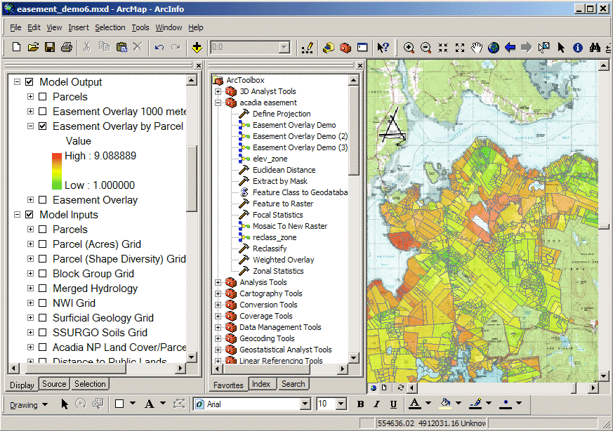
The chosen platform for this project is Environmental Systems Research Institute, Inc (ESRI), ArcMap 9.1 (Figure 1) along with Spatial Analyst 9.0. ArcMap 9.0 provides an easy-to-use interface and access to powerful analytical tools via it's ArcToolbox. Spatial Analyst was used in conjunction with ArcMap 9.0 to give the ability to use raster-based GIS data layers. This increases the applications abiltiy to process large data layers quickly and do powerful overlay analyses.
GIS themes have been collected for the project. The area of interest
has been identified as Mount Desert Island, which is the main component
of Acadia National Park. This was decided since there was complete coverage
of this area with all of the GIS themes that will be used in the study.
These themes include: Roads, Streams, Ponds, Rivers, Land Cover, Wetlands,
Surficial and Bedrock Geology, Soils, Demographic data, Tax Parcels, Negative
Sites (landfills and Industrial Facilites Discharge Sites), Critical Species
Locations, Elevation, Slope, and Flow Accumulation. In addition landscape
level effects of variations in patch quality, boundary effects, patch
context, and connectivity with respect to biological, hydrologic, and
geologic resources will be considered. |
|
|
Impact of UMESC Science
This decision support system was developed to give Park resource management staff a method with which to rank parcels according to several important ecological, anthropogenic, and landscape scale attributes. Park officials can use this decision support system to prioritize parcels for potential inclusion in the Park conservation easement program based uponsound scientific principles in a format powerful, yet easy to use.
This project was completed in 2008. |
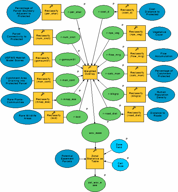
ESRI also offers it's ModelBuilder 9.1 as part of it's ArcMap program. This complimentary application allows the user to construct GIS models in a flowchart format (Figure 2). GIS data themes and ArcMap tools, scripts, and models can be dragged from the ArcToolbox onto the ModelBuilder design window. The project development participants will construct the models and alter their compositions as deemed appropriate by Park officials.
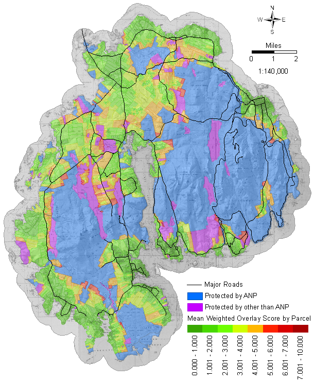
Upon completion of this project parcels were ranked for possible inclusion
in the Park's conservation easement program (Figure 3). Specific products included
a written report to Acadia National Park summarizing the criteria development
and a digital map and database of potential sites for the conservation
easement program. An integrated series of natural resource databases in
a GIS were also made available. The protocol used as the basis for
the evaluation of conservation easement properties will allow Park resource
managers to be pro-active in the protection and management of their lands.
The entire GIS was to the Park so that future changes in the
selection criteria or additional information gathered from the NPS Vital
Signs Program can be incorporated into the GIS.
|
Jason J. Rohweder1, Glenn R. Guntenspergen2, and Martha G. Nielsen3
1U.S. Geological Survey
Upper Midwest Environmental Sciences Center
2630 Fanta Reed Road
2U.S. Geological Survey
Patuxent Wildlife Research Center
3U.S. Geological Survey
Water Resources Division
196 Whitten Road
Principal Investigator: Jason Rohweder
|