
Development of a Spatial Decision Support System in Support of the Contaminant Assessment Process at Acadia National Park
The Contaminant Assessment Process (CAP) was developed by the Biomonitoring of Environmental Status and Trends (BEST) Program that now resides in the Biological Resources Division of the U.S. Geological Survey (USGS). The CAP is a standardized and comprehensive approach for assessing threats posed by environmental contaminants to refuges, national parks, and other lands managed by the Department of the Interior. The CAP provides information to land managers to support the development of management options for preventing or alleviating contaminant effects.
The CAP was first evaluated by the National Park Service (NPS) at the Congaree Swamp National Monument in central South Carolina. In 1998, a second project was initiated to further evaluate the CAP at Acadia National Park. Acadia National Park was selected because it presented a different geographical location and different ecological and contaminant transport pathways than those at Congaree Swamp National Monument.
Information for CAP has been managed using an Internet-accessible system developed through joint funding by the U.S. Fish and Wildlife Service and the BEST Program. Alternatives to this approach were evaluated. One alternative was a PC-based Decision Support System (DSS) using Environmental Systems Research Institute's ArcView® platform. To provide a realistic evaluation of the DSS as it applies to CAP, the BEST Program elected to fund the development of a prototype geographic information system (GIS)/DSS to support the contaminant assessment planned for Acadia National Park. The USGS Upper Midwest Environmental Sciences Center (UMESC) was selected to design this prototype and was subsequently funded to do so.
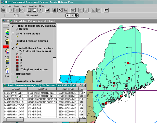
Three areas of influence (AOI) were identified for the project: Proximal air AOI (160 km radius), extended air AOI (320 km radius), and surface water, groundwater and tidal AOI (Maine Coastal Watershed). Data sets to be incorporated into the DSS were identified at a project coordination meeting at UMESC in La Crosse, Wisconsin. The list of data sets was refined through review and additional input by NPS staff . These final data sets formed the core of the DSS. The biologists and geospatial technologists at UMESC acquired, compiled, organized, and packaged the spatial and ancillary data into the DSS. Staff of the BEST Program provided some data sets, metadata descriptions of data sets provided, and guidance about CAP.
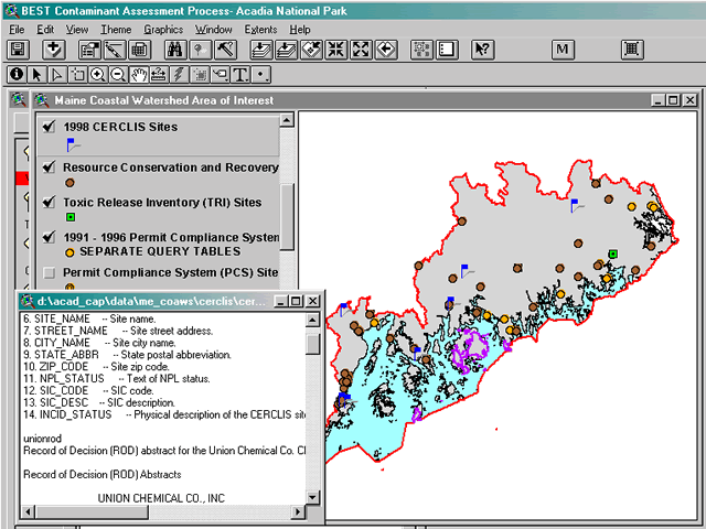
Using GIS as a platform for the DSS provided options for constructing interpretative tools that explore the spatial associations between contaminant data and the physical and biological landscape of the unit. Additionally, the GIS platform allowed the investigator to analyze, manipulate, and create new data sets that address individual agency or management concerns.
The UMESC staff delivered the final DSS to BEST Program and Acadia National Park and participated in the CAP workshop at Acadia National Park.
Plan of Study
Specific tasks of this project were as follows:
- Produce boundary coverage for air and water area of interest (AOI)
defined in CAP.
- Air AOI
- Proximal: 160 km radius from the centroid of Acadia National Park.
- Extended: 320 km radius from the centroid of Acadia National Park.
- Surface water, groundwater, and tidal AOI. These have the same AOI boundary that is the Maine Coastal Watershed (HUC # 01050002).
- Air AOI
- Develop metadata information for any newly produced data layers developed
by UMESC that includes the following information:
- Title
- Brief description (abstract)
- Production date
- Type (spatial, textual)
- Format (shape file, DBF, ASCII)
- For spatial layers, also provide list and description of table attributes
- Provide a template for metadata information for the investigators to document any new spatial layers they develop (e.g., potentially contaminated areas).
- Develop a comprehensive list of all files associated with the DSS package for CAP including spatial data (shape files) and ancillary data (lookup tables, water quality tables, species lists, bibliographies, photos, etc.).
- Develop necessary hot links for textual data, photos, etc.
- Develop templates and forms for user-supplied information required for the CAP. These templates/forms should be incorporated into the DSS. The BEST Program will provide titles and fields.
- Ensure that all spatial data layers have the same or appropriate projection parameters for a given scale.
- Convert point source data from U.S. Environmental Protection Agency (EPA) into thematic shapefiles. The BEST Program will be providing point source data.
- Modify EPA tables as necessary to accommodate specific attribute fields required as part of CAP. The BEST Program will provide a list of tables that will need to be modified and attribute fields.
- Provide complete DSS data package for CAP to the principal investigators in an appropriate format.
- Provide technical support for data sets and applications used in the DSS.
- Provide technical support and technology for demonstrations of the ArcView project at technical workshops.
- Maintain and archive digital products created for the DSS at the UMESC.
Principal Investigator: Jason Rohweder
Page Last Modified: April 17, 2018