Upper Midwest Environmental Sciences Center
|
|
| Overview/ Science Programs/ Data Library/ Products and Publications/States/ Rivers/Teach ers and Students/ Links/ Contact/ Search |
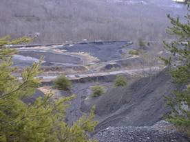
Ohio Valley Abandoned Mine LandsSpatial data
for use in the study and reclamation of abandoned mine lands (AMLs) in the Ohio
River Basin are generally available; however, Geographic Information System
(GIS) data bases are often disjointed due to political boundaries and (or) are
incomplete for the intended use. A central repository for regional GIS spatial
data is needed to facilitate efficient study and effectively allocate personnel
and resources during remediation of AML sites.
|
DescriptionTeamDataLinks |
|
Description
Team
- Midwest Area
- Charlie Peters
- Mark Ayers
- Kentucky
- Pete Cinotto
- Hugh Nelson
- Indiana
- Paul Buszka
- Kathleen Fowler
- Ohio
- Raplh Haefner
- Laura Simonson
- Upper Midwest Environmental Sciences Center
- Jason Rohweder
- John C. Nelson
Data
BASIC DATA |
|
Physiography and Ecoregions |
Political Boundaries |
Interstates, US Highways, State Highways, Railroads, and so forth |
Kentucky Area Development Districts (and other State Equivalents) |
USGS Digital Raster Graphic (DRG) Maps |
Digital Elevation Models (DEM) |
National Land Cover Data (NLCD) |
Natural Features (prairie, basin, cliff, and so forth) |
USDA National Agriculture Imagery Program (NAIP) Data |
|
HYDROLOGY |
|
USGS Streamflow-Gaging Station Information (NWIS) |
USGS Ground-Water Monitoring Information (GWSI) |
Selected USGS Water-Quality Monitoring Data (QWDATA) |
Climatic-Data Station information (NOAA and USGS) |
National Hydrography Dataset (NHD) Streams |
USDA Soils (STATSGO and SSURGO) |
Floodplains |
Aquifers |
Springs |
Selected Streamflow Statistics |
Watershed Boundaries (12-digit HUC) |
Groundwater Sensitivity Regions |
Karst Dye-Trace Data |
Wells |
Wetland Classification (LANDSAT) |
Water-Use Data |
Percent Slope |
|
BIOLOGY |
|
Bivalve Distributions and Data Collection Information |
Crayfish Distributions and Data Collection Information |
Fish Distributions and Data Collection Information |
Human Population by County (US Census Data) |
|
GEOLOGY |
|
DOE National Uranium Resource Evaluation (NURE) and other Geochemical Data |
USGS National Geochronological Data Base (NGDB) |
Bedrock Geology |
Seismic and Gravity Data |
Karst and Sinkhole Distribution |
Coal Seams / Coal Fields |
Geologic Structures |
Active Industrial Minerals |
Value of Mineral Production and other Economic Data |
USGS National Coal Resource Data System (NCRDS) |
USGS Mineral Resource Data System (MRDS) |
|
MINING AND AML-SPECIFIC DATA |
|
Active Mineral Operations |
Coal Exploration Holes and Well Borings |
Coal Availability |
Coal Availability Depth |
Coal Availability Thickness |
Coal Elevation |
Coal Mine Entries |
Coal Mine Seams |
Coal Mine Extent (Surface and Underground) |
Sand and Gravel Resources |
Abandoned Sand and Gravel Pits |
Quarries (Active and Abandoned) |
Probable Abandoned Underground Mines |
Abandoned Underground Mines and Mined Out Areas |
Petroleum Fields and Wells |
Industrial Mineral Points |
Location of Current AML Sites |
Links
Abandoned Mine Land Inventory system (amlis)
http://www.osmre.gov/aml/AMLIS/AMLIS.shtm
Ohio Department of Natural Resources: Division of Geological Survey
http://www.ohiodnr.com/Home/Home/tabid/7105/Default.aspx
Indiana Department of Natural Resources: Division of Reclamation
http://www.state.in.us/dnr/reclamation/index.htm
Illinois Department of Natural Resources: Office of Mines and Minerals
http://www.dnr.state.il.us/mines/
Kentucky Office of Mine Safety and Licensing
http://www.omsl.ky.gov/
USGS Mineral Resources
http://mrdata.usgs.gov/
Ohio River Ecosystem Team
http://www.fws.gov/orve/